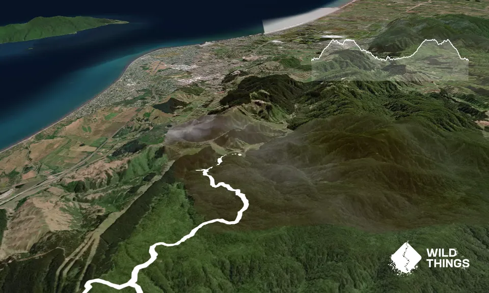
Orange Hut via PerhamsIntermediate
Submitted by Richele McKenzie
Front country - easily accessible
Loop
Undulating, small hills only
Native bushPlantation/exotic forest
Intermediate
4:00 (Slow)
2:50 (Moderate)
2:10 (Fast)
-6.4%
+6.5%
Occasionally access may be limited due to forestry works.
Fastest Known Times (FKTs)
Please set your gender to see your position on the FKT leaderboards.
The more , the harder the FKT will be to beat. Learn about Fastest Known Times.
Description
From the map/noticeboard follow Perhams Road until the signpost where it becomes Titi Road (approx 5.7k). Keep right. Approx 300m along you come to the Whakatikei Road turnoff (6kms from the start). This is the start of your loop. Turn left here and run along Whakatikei Road until the Norm's Crossing sign (approx 10.6k from start).
Turn right and continue for approx 2km until you come to Orange Hut (tucked up a track to the left and signposted). After checking out the hut head back to the turnoff and follow Hydro Valley Road (sign says to Kapiti) back to Perhams. This includes staying right at approx 14.8k and right again at the open area of felled forestry (approx 16.4k). At Perhams Road it's 6km back to the start.
Trail Community
Features of interest
Covering 15,000 hectares of wilderness area between Upper Hutt and the Kapiti Coast, Akatarawa Forest is a rugged blend of native and exotic forest. One way of exploring the Akatarawa Forest with your dog (as dogs are prohibited on nearby Campbells Mill Road and Whareroa Farm). Refer to note re 1080 drop timings. Orange Hut is popular with 4WD clubs and trail bikers as a refreshment stop.
Make Up of Run
Farm Road / 4WD Track: 100%
Route Data
Reviews:
Overlapping Runs
The following trails overlap with this run to some degree. You may wish to combine them but please note that to qualify for FKTs on these runs you should record a separate Strava activity for each
Photos:
Your Trail Wishlist
All the runs that are on your To Do list (no limit).
Add to wishlist view wishlistWild Explorers
I did it!-
Access
Maungakotukutuku Road entrance to the Akatarawa Forest. Access via either the Paekakariki side (Waterfall Road) or from Valley Road, Paraparaumu. There is a picnic table and a map at the beginning.
Plenty of parking at the entrance or along the road.
12 km
17 minutes
Yes
No
-
Staying Safe
Moderate.
Print out a copy of the Akatarawa Forest map or take one of the very handy brochures available. Also be wary, in areas of forestry signs can be knocked over and put back the wrong way.
Non-existent.
Short-sleeved thermal top, Seam-sealed waterproof jacket, Personal Locator Beacon (PLB), Whistle, First aid kit, Extra food for emergencies, Cellphone, Map.
There are plenty of water sources but the quality is unknown.
The closest toilet is at Whareroa Farm.Check the weather forecast before you set out as the route involves several river crossings and these may become dangerous when it has been raining heavily.
Aerial baiting of 1080 occurred on Friday 2 July. Following this, extra care should be taken in the area until further notice.
Hunting is not permitted, and visitors with dogs are advised to stay clear of the area until baits have become non-toxic and any possum carcasses have decomposed. This is expected to take three-four months. (https://www.gw.govt.nz/akatarawa).
The route is used by 4WD vehicles and trail bikes so listen carefully for vehicles and be wary on blind corners.
There is very limited cellphone coverage so take a PLB (if possible) and a friend when running in the Akatarawa Forest. -
Post run indulgence
Tuatara Brewery
7 Sheffield Street, Paraparaumu
tuatarabrewing.co.nz
Post-run beer and nachos.Beach Road Deli
5 Beach Road, Paekākāriki
http://www.beach-road-deli.com/
Great coffee and baking. Not open on Mondays. - Blog Posts and Articles
-
Sponsor this trail