Last Updated: 10th Apr 2026
Neill Winchcombe loop
A classic Tararua circuit with plenty of vert
Last Updated: 10th Apr 2026
Open
Grunt Factor: 97 ?
Gnarl Factor: 91 ?
36.8km
3075m
3080m


Last Updated: 10th Apr 2026
Last Updated: 10th Apr 2026
Open
Grunt Factor: 97 ?
Gnarl Factor: 91 ?
36.8km
3075m
3080m
Front country - easily accessible
Loop
Mountainous
Native bush
Open tussock/grasslands
Open ridges/tops
Technical Single Track
Untracked / Route only
Average Uphill Gradient: +16.70%
Average Downhill Gradient: -16.70%
VIP Feature: Send this route to your Garmin account so you can follow the course on your Garmin device.
Become a VIP Member to see the trailhead information.
14:00
Slow
11:00
Moderate
8
Fast
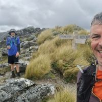
The Neill Winchcombe Circuit links the iconic Southern Crossing with the lesser-travelled Neill Winchcombe ridge. It's a serious sufferfest that rewards with goblin forest, exposed alpine tops, and a genuine sense of adventure. The route start and finishes at the Waiohine road end, firstly heading up to Cone, then west along Neill Ridge to Winchcombe and Mt Hector, south down the Southern Crossing to Alpha, and back via Bull Mound.
Cross the suspension bridge over the Waiohine River gorge and follow the well-marked track up the ridge toward Cone Hut. At the Cone Saddle junction, head up to the Cone summit. Just before the top you'll hit a track junction — take the left fork, which drops you toward Neill Saddle and onto the beginning of Neill Ridge proper.
From here the ridge is relentlessly undulating steep up and down steep, with plenty of scrambling in between. Just before the bushline you'll come to Winchcombe Biv. Top up water and start the climb to Winchcombe Peak.
There is no formed route from Winchcombe Biv to Mt Hector. At the Mt Hector summit, you join the Southern Crossing track. The memorial cross at the top was erected in 1950 as a tribute to trampers who lost their lives during World War II. Follow the track south over the Beehives, across Aston and down to Alpha Hut. The track then drops to Hells Gate before you take the signposted left junction at Omega onto the Bull Mound Track. Follow the ridge over Bull Mound then descend steeply into the Tawharenīkau Valley. The track emerges on the true right of the Tawharenīkau River, not far downstream from Cone Hut. Cross the river to the true left and follow the track upstream a short distance to Cone Hut.
From Cone Hut, take the right-hand track that climbs directly to the ridge (not the valley track to Cone Saddle). Follow the ridge south and descend back to the Waiohine suspension bridge and the road end.
This trail includes the peaks Mount Hector, Alpha, Winchcombe Peak and Neill.
Cone, Neill Ridge, Mt Hector, Alpha and Bull Mound. Mt Hector memorial to trampers who lost their lives during World War II.
Toilets are at the road end.
Heaps of parking at the road end and campsite.
15 km
Unknown
No
Moderate.
Patchy.
Thermal leggings, Lightweight fleece top, Seam-sealed waterproof jacket, Windproof jacket, Gloves, Beanie/thermal headwear, Personal Locator Beacon (PLB), Whistle, First aid kit, Extra food for emergencies, Survival blanket, Cellphone, Compass, Map
Water available at Waiohine roadend, huts and streams.
Take stock of the weather when you leave the bush just before Winchcombe. Consider turning back or waiting in the bivvy if the weather is bad or deteriorating.
If it has been raining, the Tauwharenīkau River may be high/flooding and not be passable. Consider this when you leave Alpha Hut and either wait of take alternative route out via Marchant ridge.
Do you have a suggestion on where to go afterwards for the best coffee / cake / breakfast / brunch / beer?
Trail Legend
Login as a VIP to become a Trail Legend. Learn about Trail Legends.
Fastest Known Times (FKTs)
You and Neill Winchcombe loop
As a VIP member you can record private notes for this trail, see all of your times and more.
Already have an account? Login now
These overlap with this trail to some degree. You may wish to combine them but please note that to qualify for FKTs on these runs you should record a separate activity for each.
Send to your phone
Scan the below QR code to open this trail on your phone.

Tip: position the QR code in your phone camera screen.
Plan smarter, stay motivated, track your progress, and unlock the full Wild Things experience — while saving along the way.