Last Updated: 21st Sep 2023

Experienced

Save Trail Save

I've done it Done

Eastern Main Range

Greytown, Wellington

Submitted by Seanoa Isaac

Last Updated: 21st Sep 2023

Experienced

Save Trail Save

I've done it Done

Open

Grunt Factor: 131 ?

Gnarl Factor: 81 ?

43.0km

4350m

4350m

1529m


Login as a VIP to see driving directions, distance and time.

Trail Map

Type of Run

Back country - remote

Combo

Very hilly

Dog Friendly

Native bush

Open ridges/tops

Run Makeup

10%
25%
35%
30%

Easy Single Track

Moderate Single Track

Technical Single Track

Untracked / Route only

Average Uphill Gradient: +18.8%

Average Downhill Gradient: -18.1%

Trailhead

Login as a VIP to see the trailhead information.

Estimated Times to Run

24:00

Slow

17:00

Moderate

12:00

Fast

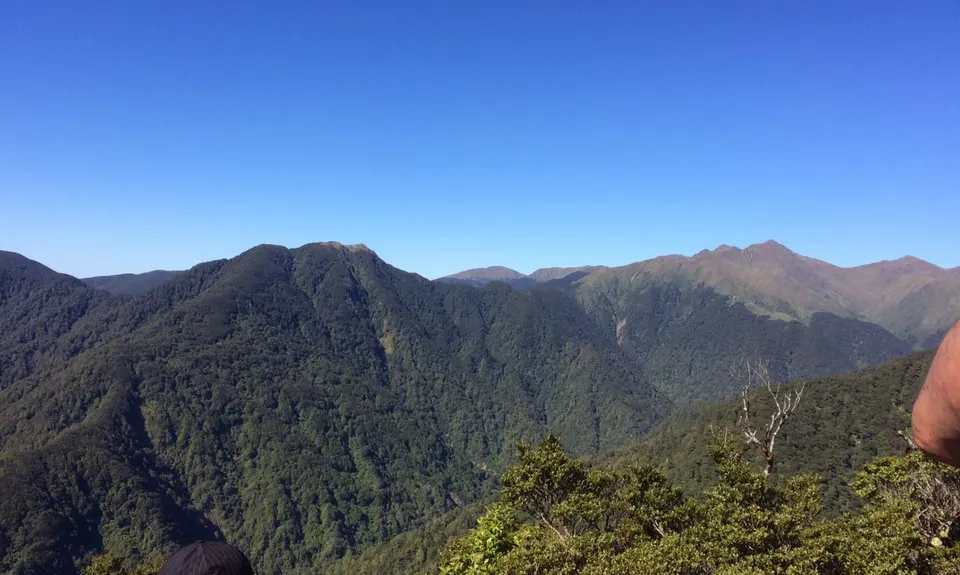
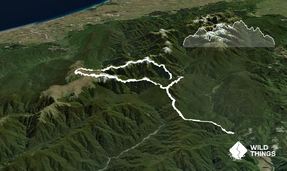
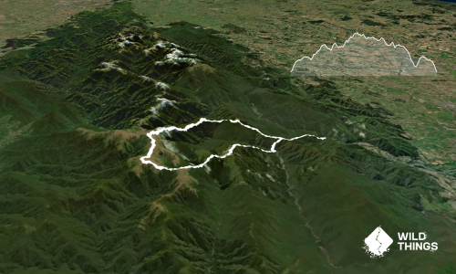
A massive back country run over what would be a 2-3 day tramp. Covering approx. 8km of the Main Range & bags 3 huts (Neill Forks, Maungahuka & Kime) this route offers outstanding views of the South Island, Mt. Taranaki & Ruapehu and everything in between on a clear day.
Route direction given anti clockwise with average splits and approx. distances:
Start Waiohine road end, head over swing bridge, turn left, head 100m, the track veers right sharply and steeply, follow for 3.7km to 1st sign, stay right towards Cone Saddle turn off 900m.
This part can be tricky especially if dark.
Go directly past the Cone Saddle sign (points right) for 30m and there will be another sign putting left to Cone Hut. Just before you reach this sign stop and look up, almost directly ahead you will see a trail blazer taking you up towards Cone Ridge.
Head up 2.5km to next sign at Cone
*2hrs.
Stay right run down Cone Ridge 3km through mossy forest, pay attention as the sign to Neill Forks Hut is in need of repair and may have fallen over and blazers can be hard to spot with morning light behind them.
Head left and steeply down 2 km to hut.
*40min
Over bridge and straight up past Concertina Knob to next sign 4km (1050m vert), turn right to Maungahuka Hut 300m for water.
*1hr 30
Back track to sign and continue past towards Kime Hut 8km (1km to the Steel Ladder).
*2hrs
Head to Mt. Hector 2km, identify Neill Ridge (runs roughly East to West) you are going to follow the ridge (very faint trail generally to South side and almost entirely unmarked until bush line) 3km to bush line. Do not recommend attempting in average to poor weather, take great care. There are some scrambles over and around tricky little knobs.
From the last small table top look for a big blazer into bush line if clear weather otherwise you may have to walk along bush edge to acquire.
*1hr 10
Bush bash & scale a few short sharp vertical knobs and duck under mossy goblin first for 3km to Neill Saddle
*50min
Stay sharp looking for sporadic blazers and trail for 2.2km to Cone junction.
*40min
Head right to Waiohine road end (via Cone Saddle junctions) for glory.
*1hr 30

This is a huge 1 dayer do not under estimate it or the Tararua's. Good luck

Mt. Hector & the Tararua Peaks with the Steel Ladder

Free parking at the campsite. The site is well frequented during Spring to Autumn. There are no public transport options.

22 km

28 minutes

Yes

No

Extreme.

Patchy.

Waterproof leggings, Thermal leggings, Lightweight fleece top, Short-sleeved thermal top, Long-sleeved thermal top, Seam-sealed waterproof jacket, Gloves, Beanie/thermal headwear, Personal Locator Beacon (PLB), Whistle, First aid kit, Extra food for emergencies, Survival bag, Cellphone, Compass, Map, Headtorch and spare batteries, Gaiters.

Water usually available at the huts-can be affected by very cold weather (pipes freezing) or long dry spells. There are a few tarns along the tops treat and/ or filter the water. Almost no streams to be had as you are predominantly on ridges

Be prepared for four seasons in one day, this is a mountain range.

Extreme weather changes quickly. No easy bail out options, be self fully self supported

The White Swan Hotel and Bar
Greytown
Great food & bevvy selection

Jack and Jill's Cafe
Greytown
Fantastic coffee. Also great food

You and Eastern Main Range

As a VIP member you can record private notes for this trail, see all of your times and more.

Register Now

Already have an account? Login now

Trail Reviews

Be the first to submit a review for Eastern Main Range!

Login to submit a review

Trail Running Community

Find people who are interested in or have completed this trail run.

You must register or login to view this feature.

Register Now

Other trails nearby
Mt Reeves Loop

Mt Reeves Loop

Length: 17.2km

Level: Intermediate

Rooty Rocky Waiohine

Rooty Rocky Waiohine

Length: 18.8km

Level: Intermediate - Experienced

Middle of Middle Earth

Middle of Middle Earth

Length: 14.5km

Level: Beginner - Intermediate

Find more trails and peaks nearby