Last Updated: 24th Apr 2025
Grand Tour de Kaimanawa
Submitted by Mal Law
Last Updated: 24th Apr 2025
Grunt Factor: 105 ?
Gnarl Factor: 69 ?
49.5km
2950m
2950m
1660m
Last Updated: 24th Apr 2025
Submitted by Mal Law
Last Updated: 24th Apr 2025
Grunt Factor: 105 ?
Gnarl Factor: 69 ?
49.5km
2950m
2950m
1660m
Back country - remote
Loop
Mountainous
Native bush
Open tussock/grasslands
Open ridges/tops
Gravel Road
Farm Road / 4WD Track
Easy Single Track
Moderate Single Track
Technical Single Track
Untracked / Route only
Average Uphill Gradient: +13.3%
Average Downhill Gradient: -13.4%
VIP Feature: Send this route to your Garmin account so you can follow the course on your Garmin device.
Login as a VIP to see the trailhead information.
13:00
Slow
10:00
Moderate
7:30
Fast
Please note: Permission must be sought from Helisika Taupo to access the private land covering the Junction Top area. This is a hunting block, and permission will not be granted if there are hunting parties booked into this area.
Helisika can be contacted with respect to access: https://www.helisika.co.nz/contact-us/
Click here for a map of East Taup Lands (the area in question is the south-west corner of Kaimanawa 1F&2B)
Click here for further information and a map of the ETL area relative to the conservation estate.
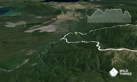
This is a true mountain run. In fact a true mountain mission. It should not be undertaken lightly, or by anyone who is not well experienced with good navigational skills, and definitely not in bad weather or with poor visibility.
From Urchin campsite follow the trail down to Pillars of Hercules (well worth a look) then pick up the gravel road, taking 2nd right, 1st left and first right to get to the start of the Umukarikari Track.
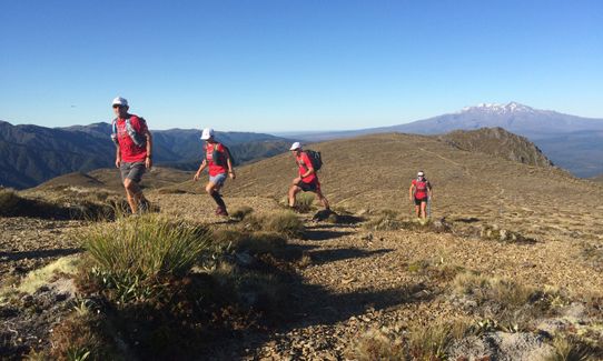
A long, steep uphill slog through the bush is eventually rewarded with stunning views and brilliant open ridge running, leading to Umukarikari (1591m) and eventually dropping steeply to the Waipakihi River. Fill up with plenty of water here as you'll be several hours along the tops before you see any more drinkable water.
Cross the river, call in at the hut to sign the intentions book and carry on following the poled route east and up, up, up to Pt 1573. Here you need to start heading south, following the sign towards Raketuangiangi. Do NOT miss this turn!
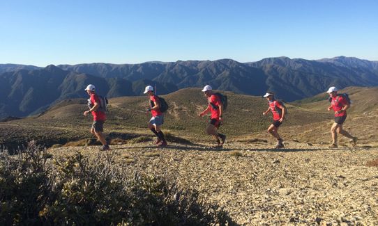
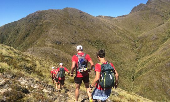
You are now in serious back country following a ridge south, that is sometimes poles and sometimes not. There is sometimes an obvious trail to follow, sometimes not. Keep a close eye on the map to avoid following a wrong spur.
You will travel over Pt1660 and eventually reach Thunderbolt (1633m), where your route starts to head in a more westerly direction again following a sketchy & sometimes unmarked route along the tops to Motutere (1646m)
From here head west over Pt1526 and then pick the right spur to get you to the marked start of the Thunderbolt Track that delivers you through the bush and back to the Waipakihi River.
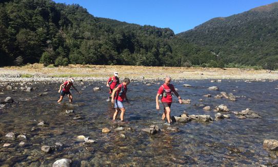
Take on more water, then head downstream initially on the far (true right) side. You will likely have to cross the river once or twice before picking up the marked start of the Urchin Track a couple of kms away. The route in the valley is again poorly marked at best but the going is relatively easy in amongst the tussocks.
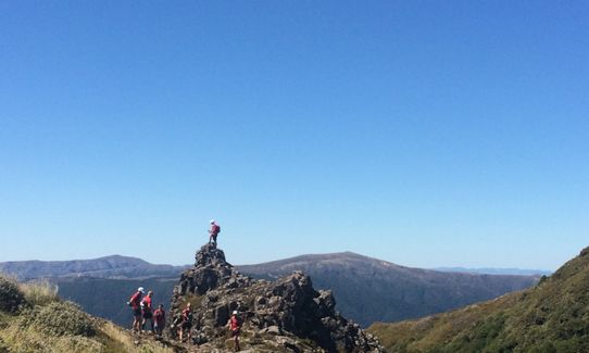
Urchin Track is a lung-busting 450m climb to your last summit of the day. Be sure to turn left (SW) after emerging from the bush, not right (which leads back to Sharp Cone and Umukarikari.)
From the top of Urchin it's a stinking 3-4 km downhill through the bush to arrive at the 4WD track that leads downhill back to Urchin campsite, a little over a km away.
Congratulations, you have just completed one of THE classic circuits in NZ mountain running.
This trail includes the peaks Motutere, Thunderbolt, Te Raketuangiangi, Umukarikari and Urchin.
Great views of Ruapehu/Ngauruhoe on a nice day (the only kind of day you want to be in here!)
Pillars of Hercules - this spectacular ravine can be viewed from a 40 m long suspension bridge very close to the start of the run.
If you know of any public toilets near the trail start or on the route, please login and then let us know so we can update this section.
Plenty of parking and toilets. There have in the past been quite a few security issues with cars in the area so make double sure not to leave any valuables inside.
0 km
0 minutes
Unknown
No
Very hard.
Do NOT attempt this route in anything other than perfect weather and be absolutely sure to take a map and compass (and have the skills within your party to use them!)
Keep a close eye on the map at all times while on the open tops. It's easy to take a wrong spur if you're not vigilant.
Very patchy.
Waterproof leggings, Thermal leggings, Lightweight fleece top, Long-sleeved thermal top, Seam-sealed waterproof jacket, Gloves, Beanie/thermal headwear, Personal Locator Beacon (PLB), Whistle, First aid kit, Extra food for emergencies, Survival bag, Cellphone, Compass, Map, Headtorch and spare batteries, Crampons / microspikes (for winter conditions), Gaiters
There is NO water on the open tops. I'd suggest leaving with at least 2L of water, fully refilling both times you cross the Waipakihi.
Only attempt this route in perfect summer weather.
Much of the route is very exposed. Take heaps of sunblock and be prepared for cold winds and sudden changes in the weather.
Crossing the Waipakihi can be treacherous when high, so do NOT attempt this route after heavy rain and make sure everyone in your party is confident with thigh-deep river crossings.
Fastest Known Times (FKTs)
You and Grand Tour de Kaimanawa
As a VIP member you can record private notes for this trail, see all of your times and more.
Already have an account? Login now
Absolutely outstanding. But heed the navigation advice. Finding your way through back half over the tops can be a bit of a challenge when visibility is limited.
October 11, 2023
Loved this run!! So much beautiful runnable tops travel. We had flurries of horizontal snow and gale force winds, with the odd bit of sunshine thrown in - ran most of it in my down jacket! If you take the Waipakihi Middle Range route from the hut to pt 1475 then pt1660 (missing Junction Top and Te Reketuangiangi) it avoids private land but cuts a few kms off the distance. Great day out.
April 27, 2023
Send to your phone
Scan the below QR code to open this trail on your phone.

Tip: position the QR code in your phone camera screen.


