Last Updated: 3rd Jan 2025
Blue Ducks & Cecil King's Hut
Last Updated: 3rd Jan 2025
Open
Grunt Factor: 39 ?
Gnarl Factor: 39 ?
23.3km
740m
740m
492m
Last Updated: 3rd Jan 2025
Last Updated: 3rd Jan 2025
Open
Grunt Factor: 39 ?
Gnarl Factor: 39 ?
23.3km
740m
740m
492m
Back country - remote
Out and Back
Undulating, small hills only
Native bush
Riverside
Easy Single Track
Moderate Single Track
Technical Single Track
Average Uphill Gradient: +9.5%
Average Downhill Gradient: -9.3%
VIP Feature: Send this route to your Garmin account so you can follow the course on your Garmin device.
Login as a VIP to see the trailhead information.
5:00
Slow
3:15
Moderate
2:15
Fast
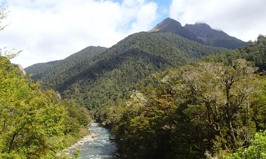
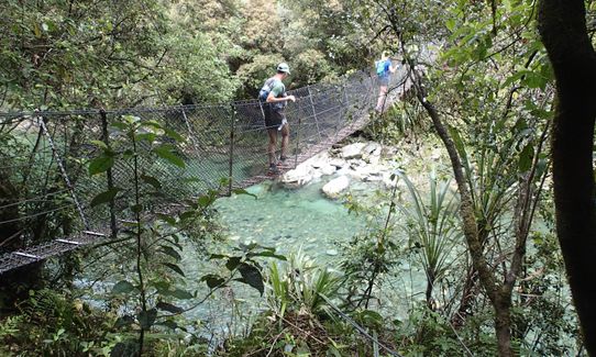
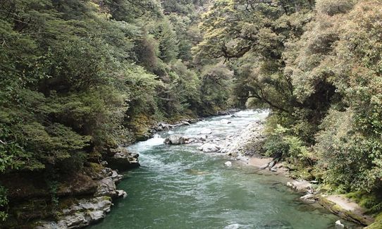
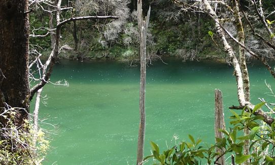
Starting at the Rolling River car park, follow the track, which soon takes you over a swing bridge. Much of the track follows the river edge, or above it, along easily run-able trails through native bush. The river is beautiful, with a mixture of rapids, large boulders and inviting swimming holes. The trail is undulating, nothing too serious in terms of ascent. Keep going until you get to Cecil King's Hut, enjoy the hut, then return the way you came.
The 59km long Wangapeka Track goes all the way to Karamea (not on this particular run though, you turn around before then). The track was built after gold was discovered in the Wangapeka Valley in 1859.
For this particular route, you run along the river valley to the historic and distinctive-looking Cecil King's Hut (details below), and back again.
Keep an eye out for blue ducks as the Wangapeka Track runs through one of eight DOC sites nationwide to secure the survival of this endangered species.
From the DOC brochure:
The 1929 Murchison earthquake caused severe damage to sections of the Wangapeka Track and totally destroyed the Mt Zetland route on the western side of the Little Wanganui Saddle. These sections were rebuilt during the 1930s depression when the government introduced a gold mining subsidy scheme for unemployed men.
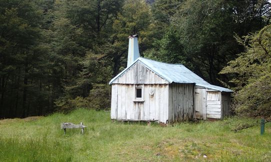
Cecil King's Hut is a relic of this time. King built the wooden slab hut in 1935. He lived in Lower Hutt and after his retirement in the 1960s, spent every summer fossicking there until 1981. He died in 1982 at 78 and his family spread his ashes around the hut. After initial restoration work in 1991 the department continues to maintain the hut to preserve its historic values.
The area contains some of the oldest rocks in the country and a wide variety, including granite, sandstone and limestone.
If you know of any public toilets near the trail start or on the route, please login and then let us know so we can update this section.
Good parking.
30 km
38 minutes
No
No
Moderate.
Less than a few hundred metres you will arrive at Kings Creek Hut, this isn't Cecil Kings Hut (it's far newer), keep going past here, until you reach the distinctive Cecil King's Hut.
Very patchy.
Thermal leggings, Long-sleeved thermal top, Seam-sealed waterproof jacket, Gloves, Beanie/thermal headwear, Personal Locator Beacon (PLB), Whistle, First aid kit, Extra food for emergencies, Survival bag, Cellphone, Map, Headtorch and spare batteries
There is no drinking water on route, take your own.
Avoid if there has been heavy rain, or about to be heavy run further up the river valley - as you may not be able to drive all the way in, or all the way out! The Dart Ford in particular can become impassable after heavy rain.
Mozzies. Take repellent. Plus flooding as above.
Kohatu Flat Rock Cafe
5087 Motueka Valley Highway
https://www.facebook.com/pg/Kohatu-Flat-Rock-Cafe-216845585057095/about/?ref=page_internal
It is the only cafe within the vicinity of Tapawera (5-10 minute drive out of Tapawera on the way back to Nelson).
Trail Legend
Login as a VIP to become a Trail Legend. Learn about Trail Legends.
Fastest Known Times (FKTs)
You and Blue Ducks & Cecil King's Hut
As a VIP member you can record private notes for this trail, see all of your times and more.
Already have an account? Login now
These overlap with this trail to some degree. You may wish to combine them but please note that to qualify for FKTs on these runs you should record a separate activity for each.
Send to your phone
Scan the below QR code to open this trail on your phone.

Tip: position the QR code in your phone camera screen.


