Last Updated: 21st Sep 2023
The Killdevil
Last Updated: 21st Sep 2023
Open
Grunt Factor: 53 ?
Gnarl Factor: 45 ?
27.0km
1415m
1415m
984m
Last Updated: 21st Sep 2023
Last Updated: 21st Sep 2023
Open
Grunt Factor: 53 ?
Gnarl Factor: 45 ?
27.0km
1415m
1415m
984m
Back country - remote
Out and Back
Very hilly
Native bush
Open ridges/tops
Easy Single Track
Moderate Single Track
Technical Single Track
Average Uphill Gradient: +12.7%
Average Downhill Gradient: -12.5%
VIP Feature: Send this route to your Garmin account so you can follow the course on your Garmin device.
Login as a VIP to see the trailhead information.
6:00
Slow
4:30
Moderate
3:00
Fast
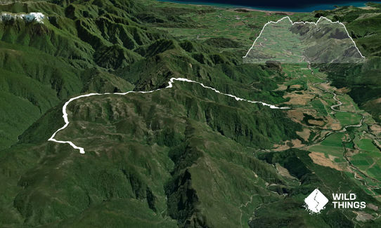
The Killdevil track is the beginning (or end) of the Waingaro Anatoki circuit and the track starts with the climb up the Killdevil - a 900 metre ascent up through regenerating bush. The hill climb has been upgraded by The Nelson Mountain Bike Club and is a never ending series of switchbacks. Mountain Bikers get flown up to the hill top for the epic switchback descent so keep and ear open !! The track is in good condition and the multiple switchbacks ease the grade...a bit !
Once at the top the track sidles along an east facing ridge then crosses over to the North side of the ridge and you are high above the Waingaro river with fantastic views down to the river and into its headwaters and over towards the Cobb. The track descends steeply in parts and is quite rough, but remains on the ridge to the turn off to Rordans hut. There is no sign at the junction, just a hut bollard and arrow pointing left (south) and the hut is 1.5 km along this track. Retrace your steps back to carpark. This is a grunty run. It's awesome and your legs will burn!!
Old 1930's gold miners trail and Roirdans Hut is an old Miners 3-bunk Hut. Hut was recently restored to original condition using locally sourced beech and weather boards. The roof shingles were hand adzed to look as good as the day it was built in 1930s.
If you know of any public toilets near the trail start or on the route, please login and then let us know so we can update this section.
The parking area is small and rough but there is a large DOC sign at the start of the track and parking for about 3 cars. The farm road is rough for 2 wheel drive cars but ok. Carpark is safe.
20 km
19 minutes
Unknown
No
Moderate.
Just be careful on the top ridge if cloud has clagged in as track markers can be hard to see - take a map and compass just in case.
Very patchy.
Thermal leggings, Lightweight fleece top, Long-sleeved thermal top, Seam-sealed waterproof jacket, Gloves, Beanie/thermal headwear, Personal Locator Beacon (PLB), First aid kit, Extra food for emergencies, Survival bag, Cellphone, Compass, Map
Take water with you and plenty of it - you will need it especially if it's a hot day. There is NO water the entire track . If it has been wet before you go there are a couple of spots after the Killdevil hill where water can be found but don't rely on it and if its been a dry summer there is NONE not even at the hut !!
The ridge beyond the Killdevil hill is long and exposed, so be prepared. In winter there is snow along the ridge
Watch out for groups of crazy down hill Mountain Bikers - don't worry this track isn't that popular so your more likely to have it to yourself.
Take plenty of water as this is a "dry" track!!
wholemeal cafe
Takaka
Its Takakas finest
the woolshed
Canaan road on top of Takaka Hill
Primo spot funky cafe
Fastest Known Times (FKTs)
You and The Killdevil
As a VIP member you can record private notes for this trail, see all of your times and more.
Already have an account? Login now
These overlap with this trail to some degree. You may wish to combine them but please note that to qualify for FKTs on these runs you should record a separate activity for each.
Send to your phone
Scan the below QR code to open this trail on your phone.

Tip: position the QR code in your phone camera screen.


