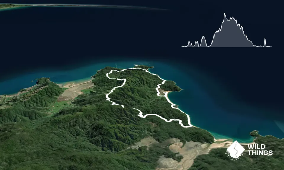
This fantastic loop can be shortened at 2 points to either a 18km or 20 km run at points where the track drops back to Totaranui.
From the visitor centre run down the road (the Avenue under the London flame trees) and turn right to follow the Abel Tasman Coast Great Walk which you will follow north all the way to Wainui Saddle. The running is superb on smooth wide trail, then along stunning Anapai Beach then climb over to Mutton Cove where at the camp the track climbs inland up to a saddle, before dropping down to Whariwharangi Beach and Hut.
Top up your water in the camp from the filtered water tap, then the track climbs out of Whariwharangi up to Wainui saddle.Turn left at the saddle onto the Inland Track and follow it south as it climbs up to Gibbs Hill. The views are amazing with views of Golden and Tasman Bays plus the entire length of Farewell Spit, and on a clear day Mt Taranaki stands proud on the horizon!
Continue south past a turnoff back to Totaranui - the track undulates over open farm land and bush to Pigeon Saddle on the Totaranui Road. Run down the dusty road and at the junction turn right to Awaroa (or left to Totaranui 4 km for a shorter day.) Run towards Awaroa and halfway down the Awaroa Road is the start of the Waiharakeke track - follow this rough track till it meets the Abel Tasman Great Walk and turn left (north). You run across 2 lovely beaches - Waiharakeke and Goat Bay - then a final steep wee climb takes you up and down back into Totaranui and a big swim!
Take water with you and fill up at Whariwharangi where there's filtered water. There are no streams after Whariwharangi till the Totaranui Road and this is a big climb section of 10 kms. Abel Tasman water is clean and pure - I've drunk from all the Park's streams for 25 years and never had an issue.
January - February is high season at Totaranui and the Camp is full. Booking way in advance is crucial to stay and the Coastal track is very busy - please give way to walkers. Sunscreen is a must and a small towel or buff to take many swims at those awesome beaches even in winter. Yes, winter if its sunny !!
The ridge along Gibbs Hill is very exposed take a jacket if windy. Watch out for cars , buses and campervans on the Totaranui Road as it's narrow winding and very dusty - wear a buff !! Watch your footing on the rough Waiharakeke Track as it's gnarly.
Swim
Totaranui beach
Summer you'll stay in for ages and yeah come on even in winter on a sunny Tasman day a quick plunge is worth it.
Totos
on the Totaranui road half way up the hill to Pigeon saddle.
Location Location Location
Do you have another suggestion on where to go afterwards for the best coffee / cake / breakfast / brunch / beer?
This - the longest of the northern AT loops adds on the wet but pretty special Waiharakiki trail plus a bit more beach running-yay! Shame about the fairly boring gravel road coming down from Pigeon saddle to start of the Waiharakiki but a clockwise direction is recommended if you prefer dry feet for the majority of the loop.
These overlap with this trail to some degree. You may wish to combine them but please note that to qualify for FKTs on these runs you should record a separate activity for each.
We don't store or share your location; it's only used for these features. You can continue without it, just without distance sorting and live map features.
Send to your phone
Scan the below QR code to open this page on your phone.
Tip: position the QR code in your phone camera screen.