Last Updated: 18th Oct 2024
Awaroa Beach & Coffee
Last Updated: 18th Oct 2024
Grunt Factor: 22 ?
Gnarl Factor: 15 ?
18.0km
505m
500m
110m
Last Updated: 18th Oct 2024
Last Updated: 18th Oct 2024
Grunt Factor: 22 ?
Gnarl Factor: 15 ?
18.0km
505m
500m
110m
Front country - easily accessible
Out and Back
Undulating, small hills only
Native bush
Beach
Coastal
Easy Single Track
Moderate Single Track
Average Uphill Gradient: +5.8%
Average Downhill Gradient: -5.7%
VIP Feature: Send this route to your Garmin account so you can follow the course on your Garmin device.
Login as a VIP to see the trailhead information.
3:00
Slow
2:00
Moderate
1:40
Fast
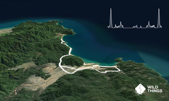
Head south from Totaranui along the Abel Tasman trail for a lovely 5km of combined beach and forest trails until you reach the Awaroa estuary.
This can only be crossed 2 hours on either side of low tide so make sure you do your maths and time your crossings right. It is likely that your shoes will still get wet. It is easier (less deep) just to follow the orange Doc signs across to Awaroa Hut but a diagonal shortcut is usually fine at peak low tide. Some runners may prefer to remove shoes for the muddiest bits.
After the crossing diagonal across to the beach and reaching the open sea, turn right and cruise down the beach towards a prominent cliff boardwalk which is the access to the Awaroa Lodge. After a well-earned coffee & cake follow the signs back via Awaroa Glamping, the airstrip, and then the orange signs that take you to Awaroa Hut before making the return crossing of the estuary. Hopefully, you got the timing right!
Head back to Totaranui along the same Abel Tasman trail for 5km until you arrive back at your car.
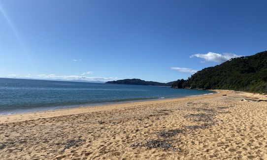
Located within the protected confines of the South Island’s Abel Tasman National Park, Awaroa Beach curves magnificently around the mesmerising shallows of an atoll-like estuary. Meandering its way for 800 metres in length, it has been nicknamed “The People’s Beach” since it was purchased by New Zealanders from a private owner after a crowdfunding campaign that received the support of some 40,000 people.
A journey here is made all the more special by the fact Awaroa is only accessible on foot and by boat, with no road access. Scenic helicopter flights do overfly the beach without being able to land. As well as the almost unbelievable scenery, Awaroa has become a haven for coastal birds, which now nest nearby.
If you know of any public toilets near the trail start or on the route, please login and then let us know so we can update this section.
It is normally possible to park right at the start of the track/end of the road. However, in summer the area will be busy with campers, caravans and children so take care.
31 km
53 minutes
No
No
Easy.
If in doubt follow the Orange DoC signs.
Patchy.
Whistle, First aid kit, Extra food for emergencies, Cellphone, Map
None, be prepared and take what you need.
The Lodge is closed in winter so your coffee stop will be what you bring for lunch!
If you do end up trapped on the wrong side of the high tide crossing then ask the lodge to arrange a water taxi back to Totaranui. Better safe than sorry!
Awaroa Lodge is the name of the game- great coffee and food.
Awaroa, Abel Tasman
https://www.awaroalodge.co.nz
The high light of the run.
Trail Legend
Login as a VIP to become a Trail Legend. Learn about Trail Legends.
Fastest Known Times (FKTs)
You and Awaroa Beach & Coffee
As a VIP member you can record private notes for this trail, see all of your times and more.
Already have an account? Login now
A stunning run with the most beautiful views! 😍 Lots of single track through native bush but also quite a bit of sand/beach/estuary running! The coffee stop is great just need to time the estuary run with the tides which was easy enough. Beach at the end is perfect for a cooling dip after!
February 8, 2023
These overlap with this trail to some degree. You may wish to combine them but please note that to qualify for FKTs on these runs you should record a separate activity for each.
Send to your phone
Scan the below QR code to open this trail on your phone.

Tip: position the QR code in your phone camera screen.


