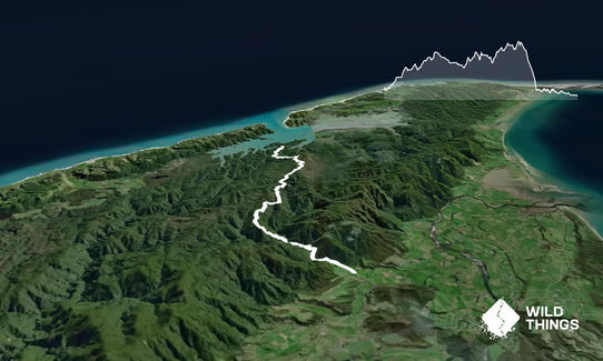
Kaituna Track Wilderness ExperienceIntermediate - Experienced
Submitted by Cheryl Steel
Back country - remote
Point to Point (one way)
Undulating, some big hills
Native bushRiversideOpen ridges/tops
Intermediate - Experienced
5:30 (Slow)
3:45 (Moderate)
2:30 (Fast)
-13.2%
+14.6%
The track was badly damaged by Cyclone Gita, and almost completely rebuilt. NOTE: The track is poorly marked and it's slow going.
Fastest Known Times (FKTs)
Please set your gender to see your position on the FKT leaderboards.
Men
Women
Filter FKTs
The more , the harder the FKT will be to beat. Learn about Fastest Known Times.
Description
NOTE: The track was badly damaged by Cyclone Gita, and almost completely rebuilt. The track is poorly marked, often not very visible, there are felled trees in many places, and it's slow going. Golden Bay SAR report that there are relatively frequently incidents.
The historic Kaituna track provides an interesting crossing from the northern west coast to the Aorere Valley near Collingwood. It passes through some pretty wild and remote country in between (don't be surprised if you think you're being chased by wild pigs!). There is no hut en route.
Head up the 4WD trail towards Knuckle Hill. It is worth taking the side trail up to the summit and back for the views over the unique Whanganui Inlet region. Continue on the Kaituna track which heads through dense native bush and up and along a two undulating bush-clad ridges (crossing a couple of streams along the way) before making a steep sustained descent into the Kaituna River where it forks. From here continue on a fast trail on the true left of this river out to the trail end on Carter Road, which is around 15k from Collingwood.
Trail Community
Make Up of Run
Technical Single Track: 60%
Moderate Single Track: 10%
Farm Road / 4WD Track: 30%
Route Data
Reviews:
Photos:
Your Trail Wishlist
All the runs that are on your To Do list (no limit).
Add to wishlist view wishlistWild Explorers
I did it!-
Access
Driving north from Collingwood towards Farewell Spit, turn left just past Pakawau and head west on a gravel road that leads over a low pass (to the West Coast) and then south through the spectacular Whanganui Inlet area. 2-3km past the Wairoa River bridge the road climbs up a prominent hill and near the top (on the left) is a signed turnoff for Knuckle Hill and the Kaituna Track. If you are being dropped off then you can start running from the start of this signed turnoff.
32 km
41 minutes
No
No
-
Staying Safe
Hard.
Make navigation of this route super-easy by using the Capra app on your phone. View on Capra .
Take a map and compass and keep a keen eye on the trail and markers. The trail is surprisingly remote, and not a good place to get lost.
Patchy.
Long-sleeved thermal top, Seam-sealed waterproof jacket, Personal Locator Beacon (PLB), Whistle, First aid kit, Extra food for emergencies, Survival blanket, Cellphone, Compass, Map.
A few streams along the way.
It's important not to do this trip in/after heavy rain as you need to cross the Kaituna River forks near the end.
Take care with navigation and following the trail; also avoid if the Kaituna River is likely to be high.
-
Post run indulgence
Mussel Inn
Between Collingwood and Takaka
https://www.musselinn.co.nz/
Good food and great atmosphere. - Blog Posts and Articles
-
Sponsor this trail