Ross to HokitikaIntermediate
Submitted by Catriona McWhirter
Front country - easily accessible
Point to Point (one way)
Totally/mostly flat
Native bushCoastal
Intermediate
4:00 (Slow)
3:00 (Moderate)
2:00 (Fast)
-1.4%
+0.9%
Fastest Known Times (FKTs)
Please set your gender to see your position on the FKT leaderboards.
Men
Women
Filter FKTs
The more , the harder the FKT will be to beat. Learn about Fastest Known Times.
Description
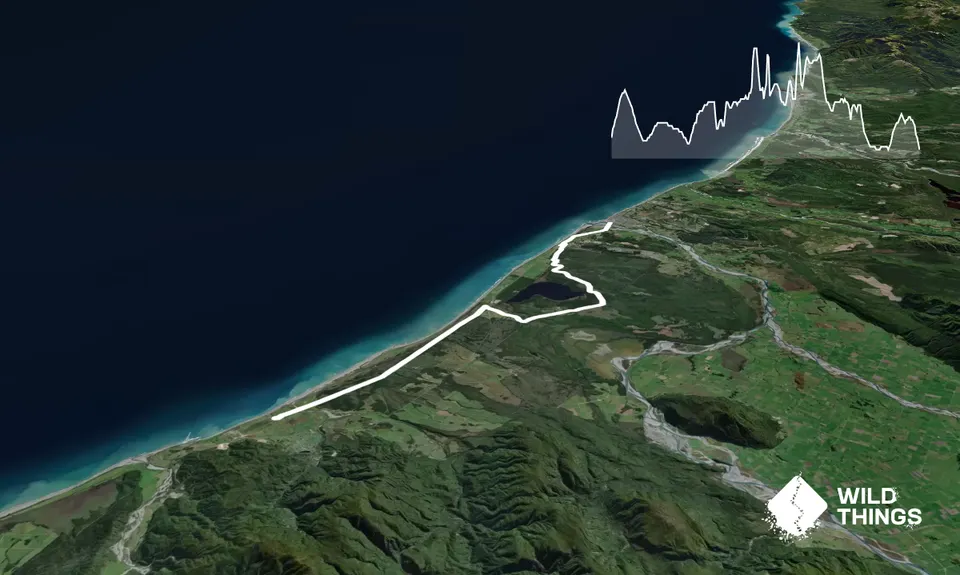
Can be done in either direction, but description is for heading North from Ross to Hokitika. Northbound, you get a slightly monotonous section out of the way first and finish in Hokitika where there are more food/rehydration options than Ross.
Beginning at the start of the historic tramway just along the road from Ross Beach Holiday Park, simply follow the bright orange West Coast Wilderness Trail signs along the tramway heading North. The first 11km of the route is pretty much a straight line along the tramway towards Ruatapu, across farmlands and creeks, with the distant sounds of the wild Tasman see and occasional views of the Alps. There is a good shelter part way along this section and a number of interesting information boards regarding the rich history of the area.
At 12km, you reach SH6 at Ruatapu, turn right and have to run alongside this (on a separate trail) for about 1km before crossing SH6 and taking the minor tarmac road towards the Treetop Walkway. This does involve a few km of tarmac road, but there is very little traffic and the views of the mountains are quite impressive on a clear day. Be sure NOT to turn left for the Treetop Walkway - just keep following the orange West Coast Wilderness Trail markers.
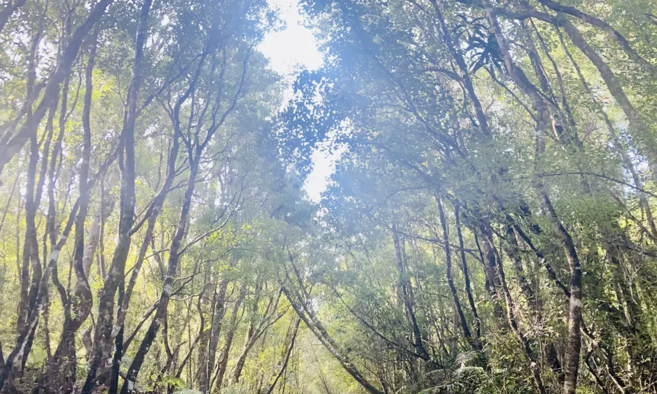
At 18km you reach the start of the Mananui Tramline (AKA Mahinapua Walkway) and will be glad to return to singletrack trail running. For the next 4km you follow a former logging tramway through native bush. The track is well maintained and makes for easy but not boring running.
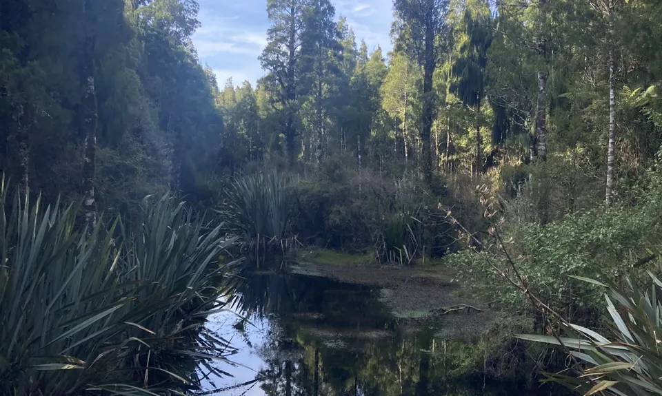
At 22km the fabulous wetland section is reached and the trail takes you across boardwalk through this amazing ecosystem. On a clear day, especially in Winter, the views of the snowcapped mountains in the distance are just sublime. The wetland section continues for a couple of km, then you're back into the bush on another lovely ribbon of singletrack which follows Mahinapua Creek for another few km.
The bush section ends at about the 26km mark, crossing a picturesque historic bridge before crossing SH6 and following the quiet minor road behind the Hokitika Golf Links. Your route follows the road for about 3km before crossing the Hokitika Bridge - a pretty stunning final furlong on a clear day. In Hokitika, there are lots of good places to rehydrate and refuel, plus plenty of good accommodation options. Or you could continue running along the West Coast Wilderness Trail all the way to Greymouth (route guides to subsequent sections coming soon).
Trail Community
Features of interest
Historic tramway, native bush and unspoilt wetlands teeming with birdlife, stunning views of the Southern Alps. Ross historic goldfields and Ross beach both worth checking out.
Make Up of Run
Untracked / Route only: 0%
Technical Single Track: 0%
Moderate Single Track: 0%
Easy Single Track: 75%
Farm Road / 4WD Track: 0%
Gravel Road: 5%
Sealed Road: 20%
Route Data
Reviews:
Overlapping Runs
The following trails overlap with this run to some degree. You may wish to combine them but please note that to qualify for FKTs on these runs you should record a separate Strava activity for each

Mananui Tramline
Length: 18.00km
Photos:
Your Trail Wishlist
All the runs that are on your To Do list (no limit).
Add to wishlist view wishlistWild Explorers
I did it!-
Access
The best place to start is where the historic tramway commences about 100m along the road from Ross Beach Holiday Park. There is parking pace for a few cars here and a West Coast WIlderness Trail sign. Alternatively, you can start in Ross and follow the West Coast Wilderness Trail signs, but this just adds 3km of road.
There is parking space for several cars at the start of the trail and also at the end in Hokitika. Best to shuttle with friends, although there are a few local shuttle options, which are listed on the West Coast Wilderness Trail website. Safety not a big concern re parking at the start/finish, but obviously take standard precautions.
1 km
1 minutes
No
No
-
Staying Safe
Easy.
Just keep following the bright orange West Coast Wilderness Trail markers. A map is also available to download from the West Coast Wilderness Trail website
Patchy.
Thermal leggings, Long-sleeved thermal top, Seam-sealed waterproof jacket, Gloves, Beanie/thermal headwear, Whistle, First aid kit, Extra food for emergencies, Cellphone, Map.
No drinkable water available on the route, so carry plenty.
Great trail for all seasons and all conditions as doesn't get particularly muddy or slippy and max elevation is 48m so you're not too exposed. West Coast climate is mild - very seldom below freezing and seldom above 30 degrees
-
Post run indulgence
Hokitika Sandwich Company
83 Revell Street, Hokitika
https://www.facebook.com/TheHokitikaSandwichCompany
Awarding-winning, tasty food. Staff are lovely. Does veg options.Ramble & Ritual Cafe
51 Sewell Street, Hokitika
https://www.facebook.com/RambleandRitual/
Friendly cafe with good baking, light meals and decent coffeePorky's Takeaways
51 Weld Street, Hokitika
Eating fish and chips at Hokitika's iconic Sunset Point whilst watching the sun sink towards the horizon is a perfect way to end a West Coast run - Blog Posts and Articles
-
Sponsor this trail