Last Updated: 13th Feb 2024

Experienced

Save Trail Save

I've done it Done

Mt Brown Pt 2

Mt Brown Hut

Mt Brown Hut

Kokatahi, West Coast

Submitted by Tony Hart

Last Updated: 13th Feb 2024

Experienced

Save Trail Save

I've done it Done

Open

Grunt Factor: 35 ?

Gnarl Factor: 492 ?

6.5km

1060m

25m


Login as a VIP to see driving directions, distance and time.

Trail Map

Type of Run

Back country - remote

Point to Point (one way)

Mountainous

Native bush

Riverside

Open tussock/grasslands

Open ridges/tops

Other

Run Makeup

10%
90%

Farm Road / 4WD Track

Technical Single Track

Average Uphill Gradient: +837.0%

Average Downhill Gradient: -16.6%

Trailhead

Login as a VIP to see the trailhead information.

Estimated Times to Run

Not suitable

Slow

3:00

Moderate

1:15

Fast

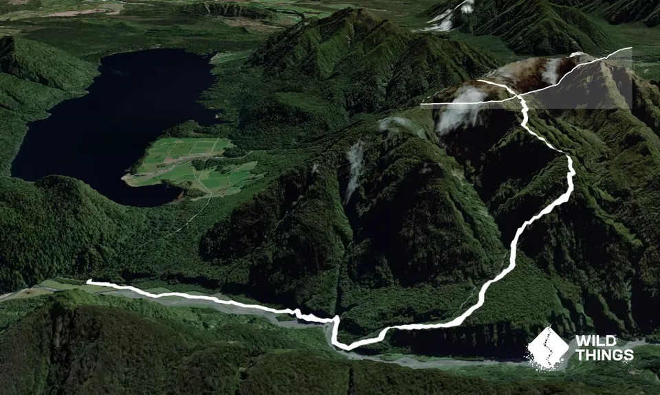
Start from the Styx River carpark. Follow the farm trail, avoiding the mud, for approximately 1.5km to the bluffs. Don't try to navigate the bluffs in high water. After the bluffs is a 100m patch of stinging nettle - take care. Approximately 200m from the bluffs is a creek crossing. Immediately after crossing to the TL of the creek, turn left and look for a white permolat marker on a tree to your right, this marks the start of the track.

The track weaves through windfalls and ferns before hitting an exposed spur. Follow this to the beginning of the climb. Around 850m elevation is a patch of rusted iron which appears to be covering a hole. At 950m elevation drop into a rocky gut and follow for 150m. Veer right (TL) when you see a well worn set of steps to the right. Follow this groove to the scrub and then on to the tussock.

From the tussock edge to the hut is about 10 mins (if fast). Sit down and make a brew, you've earned it :)

Mt Brown Hut. Some cool trees with placards.

If you know of any public toilets near the trail start or on the route, please login and then let us know so we can update this section.

Park at Styx River carpark. Can return same way or combine with descent down front of Mount Brown. If necessary can bike or get a pick up at the other end. Loop segment/track starts from Geologists Creek carpark so the shit bit comes first.

13 km

15 minutes

Unknown

No

Hard.

Take topo map and gpx on phone as track can be quite overgrown and can be multiple windfalls in short distance as well.

Non-existent.

Lightweight fleece top, Long-sleeved thermal top, Seam-sealed waterproof jacket, Gloves, Beanie/thermal headwear, Personal Locator Beacon (PLB), Whistle, First aid kit, Extra food for emergencies, Survival bag, Cellphone, Map, Headtorch and spare batteries

Plenty at the bottom. Boil water at the hut.

Don't run in heavy rain or high water. Could be crappy in winter.

Exposure; mud; technical; weather; navigation;

You and Mt Brown Pt 2

As a VIP member you can record private notes for this trail, see all of your times and more.

Register Now

Already have an account? Login now

Trail Reviews

Be the first to submit a review for Mt Brown Pt 2!

Login to submit a review

Trail Running Community

Find people who are interested in or have completed this trail run.

You must register or login to view this feature.

Register Now

Overlapping Trails

These overlap with this trail to some degree. You may wish to combine them but please note that to qualify for FKTs on these runs you should record a separate activity for each.

Mt Brown Bonanza

Mt Brown Bonanza

Length: 14.1km

Level: Experienced

Other trails nearby
Running Rapidly

Running Rapidly

Length: 14.0km

Level: Beginner - Intermediate

Find more trails and peaks nearby