Last Updated: 5th Jan 2025
Mataketake Tops Loop
Submitted by Eva Dethlefsen
Last Updated: 5th Jan 2025
Open
Grunt Factor: 62 ?
Gnarl Factor: 48 ?
31.0km
1690m
1685m
1269m
Last Updated: 5th Jan 2025
Submitted by Eva Dethlefsen
Last Updated: 5th Jan 2025
Open
Grunt Factor: 62 ?
Gnarl Factor: 48 ?
31.0km
1690m
1685m
1269m
Back country - remote
Loop
Mountainous
Native bush
Open ridges/tops
Easy Single Track
Moderate Single Track
Technical Single Track
Average Uphill Gradient: +10.2%
Average Downhill Gradient: -10.1%
VIP Feature: Send this route to your Garmin account so you can follow the course on your Garmin device.
Login as a VIP to see the trailhead information.
9:00
Slow
6.5:00
Moderate
4.5
Fast
The loop is well marked and signposted.
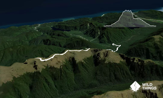
The trail starts from the carpark by the DOC sign. The run starts with a gradual climb of the old Cattle Track which was originally bulldozed along the river and is therefore well benched and very enjoyable to run.
A small two-minute detour is worthwhile to have a look at the signposted Blowfly Hut.
After about 9km turn off the Cattle Track and head up the signposted Mica Mine Tops Route towards the Mataketake Hut. The climb is well benched and zigzags up 23 corners towards the open tops.
Once through the bushline the track becomes rougher along the poled route through tussock and rocks past small tarns. The newly build Mataketake Hut is a great lunch spot.
Past the hut, the track drops steeply on rooty and slippery terrain before regaining the Cattle Tack just before the Maori Saddle Hut.
From here it is a very enjoyable gradual 13km descent back to the carpark.
This loop was only recently made possibly in 2021 with the construction of the Mataketake Hut and track markings over the tops creating one of the most accessible backcountry loops in Westland. Run on parts of the Historic Paringa to Haast Cattle Track and re-opened Mica Mine Track (built during the Second World War). At lower altitudes, the track passes through mature beech, rimu and hardwood forests before climbing to the undulating tussock tops that feature tarns and stunning views northwards along the Southern Alps to Aoraki/Mt Cook.
If you know of any public toilets near the trail start or on the route, please login and then let us know so we can update this section.
There is a small parking area on the side of the road (the sign is labelled Haast - Paringa Cattle Track).
273 km
203 minutes
Unknown
No
Moderate.
This route is a no go in bad weather as one could easily lose sight of the poles along the Mataketake tops even though the track is easy to follow on a clear day. The route is well marked with DOC signs and times to the next hut throughout the track.
Non-existent.
Thermal leggings, Short-sleeved thermal top, Long-sleeved thermal top, Seam-sealed waterproof jacket, Windproof jacket, Gloves, Beanie/thermal headwear, Personal Locator Beacon (PLB), Whistle, First aid kit, Extra food for emergencies, Survival bag, Cellphone, Map
Several creek crossings along the way provides water. There is also an untreated water source at each of the huts.
The tops section can be very exposed to that West Coast weather and can change quickly with rain and high winds. The small unbridged creek crossings along the way could easily rise in heavy rain. You want the glorious views from the tops so pick a fine day.
Be backcountry smart and remember to be self-sufficient and prepared in case of an emergency.
Trail Legend
Login as a VIP to become a Trail Legend. Learn about Trail Legends.
Fastest Known Times (FKTs)
You and Mataketake Tops Loop
As a VIP member you can record private notes for this trail, see all of your times and more.
Already have an account? Login now
I loved this loop! The pack track was very runnable, even in the uphill direction, due to the lovely gentle gradient. When I did it in December 2023 there was quite a bit of windfall on the upper section between the two turn offs to the tops. I had low cloud for the tops section and was a bit nervous about navigation, especially with all the DOC warnings, but it was very easy to follow with very frequent orange poles and a pretty clear ground trail most of the way. Overall a very fun, largely runnable loop (except for the ascent and descent from the tops), and having three huts to bag along the way is pretty cool too.
February 10, 2024
Send to your phone
Scan the below QR code to open this trail on your phone.

Tip: position the QR code in your phone camera screen.


