Last Updated: 2nd Jan 2025
Mt Owen via Granity Pass
Last Updated: 2nd Jan 2025
Open
Grunt Factor: 66 ?
Gnarl Factor: 79 ?
23.0km
1800m
280m
1875m
Last Updated: 2nd Jan 2025
Last Updated: 2nd Jan 2025
Open
Grunt Factor: 66 ?
Gnarl Factor: 79 ?
23.0km
1800m
280m
1875m
Back country - remote
Out and Back
Undulating, some big hills
Native bush
Riverside
Open tussock/grasslands
Open ridges/tops
Other
Moderate Single Track
Technical Single Track
Untracked / Route only
Average Uphill Gradient: +117.4%
Average Downhill Gradient: -18.2%
VIP Feature: Send this route to your Garmin account so you can follow the course on your Garmin device.
Login as a VIP to see the trailhead information.
8:30
Slow
6:00
Moderate
4:30
Fast
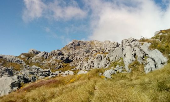
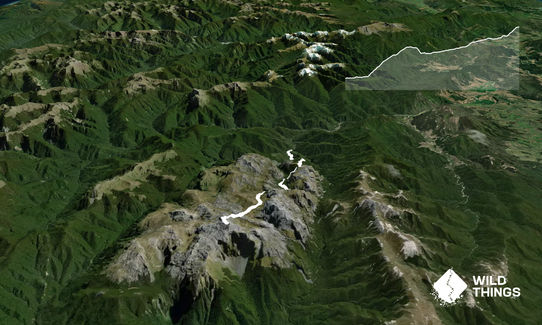
The exit from the 'Mines of Moria' (where Gandalf fell into darkness), and the highest point in Kaharangi National Park, Mt Owen is a spectacular high limestone landscape with sweeping views on a clear day. Most easily approached from Courthouse Flat to the north. A marked track/route the whole way, making for pleasant and varied running.
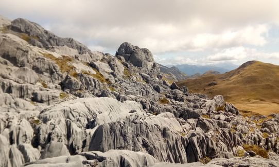
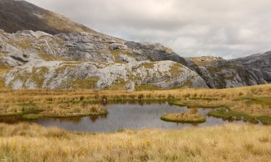
Cross the bridge and head up either the stream or the ridge following a well-marked track. A short steep descent (`the staircase') drops you down into an eerie forest, a dry stream bed and eventually Granity Pass Hut. From here follow ground trails and markers up across a low pass, where you see Mt Owen for the first time straight ahead. A trail leads down past the tarns then up along and up the fissured limestone bluffs to the broad summit. The true summit is east (remains of a trig) and if you look closely you will see a large sleeping dragon curled up below you to the east. Return the same way (with the choice of the two tracks at the end).
This trail includes the peak Mount Owen.
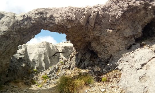
Interesting geography and bush, quite unique. The cast features on Mt Owen are particularly amazing - like walking on a heavily crevassed glacier, but of rock rather than ice.
If you know of any public toilets near the trail start or on the route, please login and then let us know so we can update this section.
Plenty of parking at Courthouse Flat. Seems safe parking, and far from the road.
34 km
44 minutes
No
No
Moderate.
Although it's tracked, make sure you have a topomap and compass. Note where the trail enters and exits the dry streambed in a section below the hut so you are confident of following this on the return. In fine weather, there's no issue navigating the route from Granity Pass to Mt Owen (and there is a trail and cairns) but if cloud comes in take more care with navigating this section.
Non-existent.
Long-sleeved thermal top, Seam-sealed waterproof jacket, Beanie/thermal headwear, Personal Locator Beacon (PLB), Whistle, First aid kit, Extra food for emergencies, Survival blanket, Cellphone, Map
Water at hut and various streams along the way
Will be under snow in winter.
Watch your footing on Mt Owen - the rock is grippy and it's not difficult, but take care not to disappear down a crevasse while you're gazing at the scenery.
Trail Legend
Login as a VIP to become a Trail Legend. Learn about Trail Legends.
Fastest Known Times (FKTs)
You and Mt Owen via Granity Pass
As a VIP member you can record private notes for this trail, see all of your times and more.
Already have an account? Login now
Ridge track is all clear and perfect for winter climbing! An excellent weather window is essential for this one due to the remote location and potentially treacherous access [Dart River ford] Well worth the effort for the uniquely stunning landscape and bonus whio sightings:)
July 4, 2023
Some of the most phenomenal scenery I’ve ever seen. It’s indescribable. You just have to do this trail to fully appreciate it.
April 23, 2022
Brilliant route and views. I would suggest going up the blue creek way as the bottom of the ridge track is extremely overgrown for the first km (Dec 2021). The ridge is also very hot in summer. Stock up on water at the hut as it’s really the only place on the trail where water is available. Also, add 25% to all of the suggested times - as an indication the fastest return time on Strava is 4hrs 45min!
December 24, 2021
Send to your phone
Scan the below QR code to open this trail on your phone.

Tip: position the QR code in your phone camera screen.


