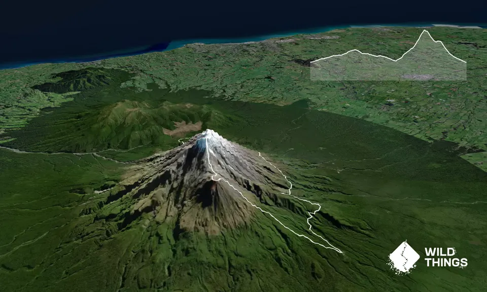
Start running the well-formed around the mountain track to Stratford Plateau from Dawsons falls. This is all runnable.
On arriving at the Plateau turn left and head up the middle of the car park and around a locked gate. The wide gravel track/ road takes you up to Manganui ski field flying fox and then turns into a moderate technical single trail for the next 4-5kms passing the ski field and slowly ascending to the junction with the Taranaki Summit Track.
Just before the summit track, there is a right turn junction to Tahurangi lodge. Go to the lodge and turn left to start up the summit track. After about 30m take a right turn to carry on the around the mountain track heading to Holly Hut.
The next 7 km is still quite runnable but a little more technical and rocky in places. The track takes you down, but around the mountain, across some spectacular slips and a view point at 12km which affords awesome views of Ahukawakawa swamp, Henry peak and New Plymouth, finally descending down to Holly hut. This is a good place to fill up with water from the hut or nearby streams as the next 4 kms is straight up to the summit of Taranaki and is quite challenging.
The route is called the Carrington ridge route. To find the start, walk back about 5 -10m from Holly hut and turn right up a small stream. About 10m up the stream is the entrance to the track and is marked by some pink and blue ribbons on the bush. The first 50m of the track may leave you wondering if you have taken the correct route but the track soon becomes very very obvious as a well formed track up the steep slope through the bush.
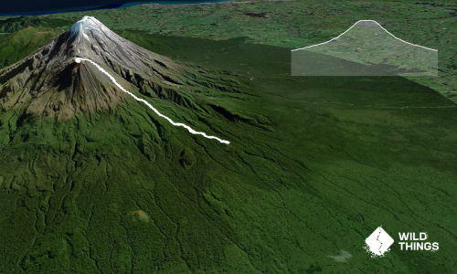
Once you come out of the leatherwood onto the more grassy tussock you will be surprised to find a very obvious route up the mountain which is well marked with large white poles. Follow these up until the track seems to disappear into a rocky face of boulders called the Hammer at about 1829m. It seems slightly steep but is quite easy to climb the 10-20 metres of boulders to get to the next grassy tussock slope on top of the Hammer. The uninitiated may feel a bit of exposure climbing the Hammer. There are no more poles after the base of the Hammer.
The tussock on the top of the Hammer gives way to a rocky ridge. Follow this up to pass just East of a large ridge and peak called the Turtle until you reach the loose rocky Heberley Ridge which you follow (slightly east) to the Summit of Taranaki at 2518m. After taking in the view from the top drop down East onto the snow/glacier in the Crater.
The crater floor has a glacier that is relatively flat and easy to cross as it is soft during normal summer conditions. Head south down the glacier. You will see two poles on the crater rim up ahead. Head to the taller one on the right. When you reach the pole you will be looking down the south slope onto Fanthoms' peak. This is a steep scree slope that is fun to slide down (standing) with caution.
Note: this is only a summer route as in the winter the slope is covered in ice and can only be traversed with crampons and ice axe. However, in the summer it is loads of fun.
Do not descend directly from the Pole as the scree here is very thin. Traverse about 40m West around some bare rock and then descend into the thicker scree. Descend to the bottom of the south slope; there are some tracks and the occasional pole.
At the bottom (the saddle between Fanthoms' peak and Taranaki) there is a very obvious poled route to the left. Ignore this and take a less obvious poled route on the right that leads up onto Fanthoms' peak. As you reach the top of the climb you will have Syme hut to your right and the summit of Fanthoms' peak will be straight ahead. Stop off at Syme hut to refill with water and fill in the log book.
Continue straight ahead and follow the tracks up to the summit of Fanthoms peak. Then take a left and head south down the ridge to get some views of South Taranaki. Turn left down a small scree slope and up the other side to meet a well-marked poled route. Turn right and follow the poles down Fanthoms' peak which is a mix of scree and rock until you meet some steps about 3km from the finish.
The last 3km is moderate single technical track/steps which is runnable all the way back to the car park.