Last Updated: 2nd Oct 2023

Beginner

Save Trail Save

I've done it Done

Southern Oban Trails

Oban, Southland

Submitted by Fiona Stechmann

Last Updated: 2nd Oct 2023

Beginner

Save Trail Save

I've done it Done

Open

Grunt Factor: 14 ?

Gnarl Factor: 12 ?

14.0km

400m

400m

90m


Login as a VIP to see driving directions, distance and time.

Trail Map

Type of Run

Urban fringe

Loop

Undulating, small hills only

Native bush

Coastal

Open farmlands

Run Makeup

15%
20%
10%
55%

Sealed Road

Gravel Road

Farm Road / 4WD Track

Easy Single Track

Average Uphill Gradient: +6.4%

Average Downhill Gradient: -7.4%

Trailhead

Login as a VIP to see the trailhead information.

Estimated Times to Run

3:00

Slow

2:15

Moderate

1:30

Fast

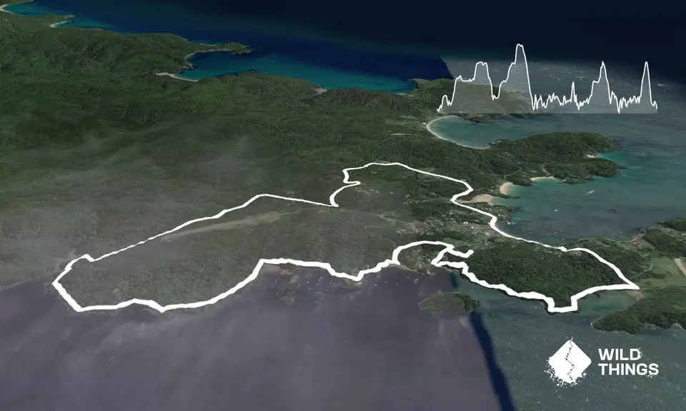
Head out of town on Horshoe Bay Road crossing two small one-lane bridges and then turn left onto Hicks road.

Follow Hicks Road all the way to the end and then turn left onto Back road (note this is a good spot for night time kiwi spotting)

Follow Back Road until it joins Main Road and turn right (If you want to do a shorter loop then you can just run straight here from town but Back Road is a nice warm up through lovely bush).

Head up Min Road until you reach the track car parks and follow the Ryans Creek track. Continue following Ryans Creek track around the back of the airport and down to the coast. Stay on the same track and try to avoid tripping as you take in the view!

When you reach the end of the trail follow the road for a short distance. You are looking for the Raroa Walk trail, it is a little hard to see but is on the corner of the 1st road on the left (the road says no entry). Follow this short but fun track up to Traill Park. Go straight across the park to Golden Bay Road. From here you can do a short but rewarding "dash" up the hill to "Observation Rock" before retracing your steps back down to Golden Bay Road and then turn left (if you have come down from Observation Rock) and follow the road down to the shore where you are looking for the Golden Bay track.

This one is great stair training! Follow the Golden Bay track all the way round to Deep Bay road, and then turn left up the hill. Just past the corner turn left onto the Peterson Hill track (also called the "path from Deep Bay"). At the end of this you will join Peterson Hill Road and follow this down and back along the waterfront into town.

Either run from the ferry terminal or your accomodation. There is plenty of parking in Oban if you have a car.

0 km

0 minutes

Unknown

No

Moderate.

Generally good.

Long-sleeved thermal top, Seam-sealed waterproof jacket, Whistle, First aid kit, Extra food for emergencies, Cellphone, Map

Some water is available but it might be easiest to carry a small amount

Muddy at all times in patches but generally good surface

Trail Legend

Mike Tennent

Mike Tennent

has completed Southern Oban Trails once in the last year.

Learn about Trail Legends.

You and Southern Oban Trails

As a VIP member you can record private notes for this trail, see all of your times and more.

Register Now

Already have an account? Login now

Trail Reviews

I really enjoyed this run earlier this year. I would go so far as to say that those trails on the coast south of Oban are better than the Rakiura track - certainly better maintained but more scenic and more fun. I would definitely run this one again!

Daniel Pettigrew

November 30, 2022

A great wee tour of Stewart Island, easily accessible from the town and a great variety of scenic trails. Provided a great short break from the kids 😂

Matthew Tyrrell

February 8, 2021

Login to submit a review

Trail Running Community

Find people who are interested in or have completed this trail run.

You must register or login to view this feature.

Register Now

Overlapping Trails

These overlap with this trail to some degree. You may wish to combine them but please note that to qualify for FKTs on these runs you should record a separate activity for each.

Rakiura Coast to Coast

Rakiura Coast to Coast

Length: 38.0km

Level: Intermediate - Experienced

Other trails nearby
Bragging About Horseshoe Point

Bragging About Horseshoe Point

Length: 7.4km

Level: Beginner

Southern Circuit Fastpack

Southern Circuit Fastpack

Length: 76.2km

Level: Intermediate - Experienced

Bungaree Half Marathon +

Bungaree Half Marathon +

Length: 23.0km

Level: Beginner - Intermediate

Rakiura Track

Rakiura Track

Length: 35.0km

Level: Beginner - Intermediate

Find more trails and peaks nearby