Its time the trail guide had a Rakiura/ Stewart island option, and why not start with the one that goes Coast To Coast?
From the wild expanse of amazing Mason Bay on the West Coast all the way to the tranquillity of Rakiura's only town, Oban, on the East Coast, there are not many places in NZ where you can go coast to coast in (just) under a marathon distance, but in this author's humble opinion this is by far the most amazing of the options- the others being in Auckland and upper Northland.
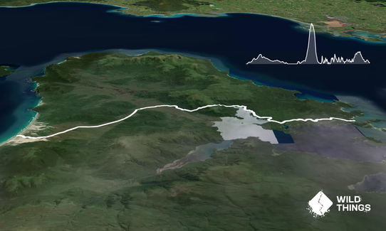
See the transport section and web links for getting there - either fly or boat/walk in. You start on the broad sandy beach Mason Bay beach at Duck Creek, on part of the legendary 10 day NorthWest Circuit (another run challenge there anyone?) You'll quickly emerge through the dunes to Mason Bay Hut (DOC) where if you can you really should take the opportunity to spend the night. Then its into the run proper.
The first 16km or so to Freshwater Hut is almost totally flat and a real breeze through tussock and scrubby landscapes and later some bush areas - so long as its dry. If wet some of the boardwalks can disappear under water a bit - be prepared for this as Stewart Island's climate is notoriously fickle. There are lots of boardwalk sections through the more swampy areas, interspersed with cruisy straight line trail travel. Take time to check out the old farming heritage as you start around Island Hill homestead, etc.
The next section from Freshwater to North Arm (11km approx) is a bit more of a gut buster on a less defined trail that is steep at times and more often that not muddy. Not as muddy as the legendary NW circuit, but you'll want good grippy soles on your feet. Its about 350m of pretty much relentless ascent onto the Thompson Ridge, and then straight down the other side until you pick up the sea at North Arm. Skirt a number of bays and headlands for a few more clicks from here and you'll be at North Arm Hut.
The third leg soon becomes easier going again as its the moderately undulating southern section of the Rakiura Great Walk track. Suitably graded and formed for some nice fast running as you freewheel (if tired legs allow!) another 12 km or so through native forest and the odd historic site. There are some fantastic views, a bit reminiscent at times of being in the Marlborough Sounds. To finish off take a left onto the Ryans Creek Track to join the Fern Gully track the last couple of kms into town and hopefully the South Seas Hotel is open for a beer and some kaimoana.
Book some accommodation in Oban and soak up the vibe that is NZ's southernmost town, and bask in the reflected glory of your journey from the wild Tasman Sea to the more placid Pacific Ocean side at Halfmoon Bay. If you don't enjoy this adventure then you aren't a trail runner, end of story!
Rakiura National Park- swamps, kiwis, historic sites, native birds and two oceans!
If you know of any public toilets near the trail start or on the route, please login and then let us know so we can update this section.
There are obviously a few logistics to organise for this run, but its not as hard as you might think. Refer to the attached websites for ideas.
No roads at the 'trailhead', so no parking! You can be dropped off by commercial aircraft on the Mason Bay beach and run the route straight out to Oban, or else come in the day before via the plane or by boat to Freshwater Inlet and walk into Mason Bay Hut (15.5km) for a wonderful night chasing Kiwi and chilling out in a truly remote wild location.
0 km
0 minutes
Unknown
No
Moderate.
You'll want the maps from the DOC site or a good old fashioned topomap. Trails are pretty well definted and marked, you shouldn't have too much drama. Note the GPX file loaded is a computer based backfill so especially over the Thompson Range there might be a small variance here and there.
Good water supplies at the three DOC huts along the way
Stewart Island is located down deep into the "Roaring Forties" and as such the weather regularly changes rapidly and often. Be prepared for anything at anytime of year down here, and enjoy the fun of it! You could do this at eny time of year, but we warned winter is a lot rougher, and the daylight hours are waaaaaaaay shorter compared to summer.
A few creeks and streams can flood, and could be an issue after heavy rain especially between Freshwater and North Arm
Awesome coast to coast run. From the beach it's pretty flat and a bit muddy in parts all the way to freshwater. Then the grunt starts up Thompson's ridge and a couple of creek crossings. Once you get to Northarm it's a nice undulating run out. Be prepared for wet feet the entire run. Such an adventure
These overlap with this trail to some degree. You may wish to combine them but please note that to qualify for FKTs on these runs you should record a separate activity for each.
We don't store or share your location; it's only used for these features. You can continue without it, just without distance sorting and live map features.
Send to your phone
Scan the below QR code to open this trail on your phone.
Tip: position the QR code in your phone camera screen.