Wild Things - New Zealand's trail running community
New Zealand's trail running community

Login


don't have an account?

Lorn Peak Lunacy, Otago

Trail Directory proudly supported by Further Faster

Update Your Header Picture

Lorn Peak LunacyIntermediate - Experienced

Submitted by Fleur Douglas

Info Info
Map Loading

Trail Information

12.30km

1280m

1280m


Otago

Kingston

Front country - easily accessible

Out and Back

Mountainous

Open farmlands
Open tussock/grasslands
Open ridges/tops

Intermediate - Experienced

05:45 (Slow)
04:00 (Moderate)
02:30 (Fast)

-21.5%

+21.5%

The lower half of this route is closed during Sept/Oct for lambing.

Download PDF Guide
View trail on Capra App

Fastest Known Times (FKTs)

Please set your gender to see your position on the FKT leaderboards.

Men

Show more

Women

Show more

Filter FKTs

The more , the harder the FKT will be to beat. Learn about Fastest Known Times.

Missing your time?

Register or login as a VIP and get yourself on the FKT leaderboard!

Register Now

Description

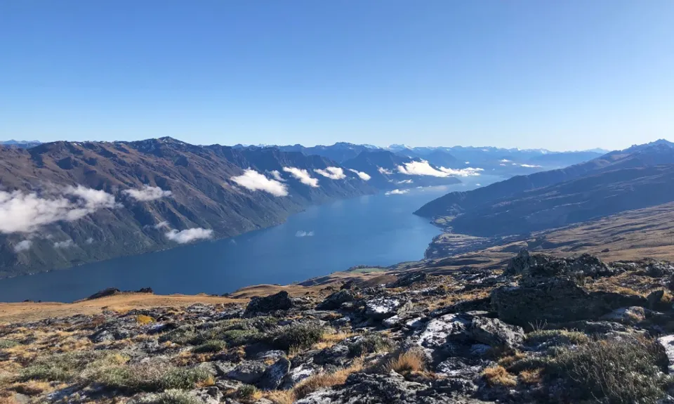
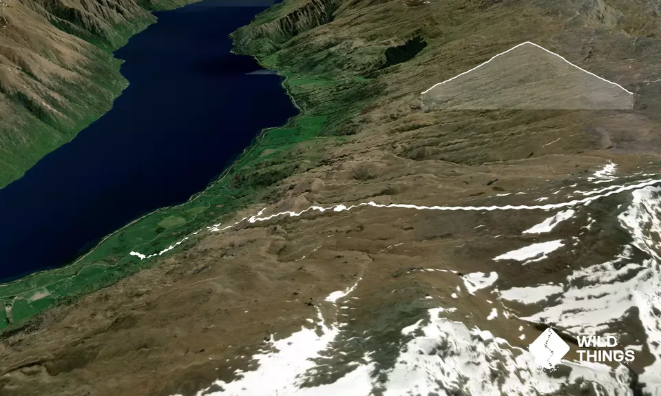
Are you ready? Let's go! From the stile at the end of the access road, the route is following the orange poles up the relatively overgrown farm road. Be prepared for some steep ascents as there's more than 200m climbing in the very first kilometre. It's always good to start a run as far into VO2Max as possible! There's limited chances to catch your breath on the way up, both from the spectacular scenery and from the sheer steepness of the terrain. It does get better the higher you go, but for the most part, remember those zigzags you saw going up the mountain on your drive in? You're following them all the way up to the top - which is further back than the false summit you see from the road.

After around 2.7km, you cross another fence and stile onto the conservation land. From here, there's a loop track that goes off to the left - ignore it and continue on up the hill. After about 500m, you run out of trail, and from then on, you're on your own! The best way to the top is to directly follow the fenceline - it leads right to the summit. You cross through some tall tussock and the steep terrain continues. Be aware that there is water underfoot here and it will freeze in winter.

Once you get onto the summit pyramid the tussock gives way to rocky terrain - the fenceline curves away to the left and so do you. Beware of getting your hopes up for false summits, as there's about three of them. But before you know it, there'll be nowhere further to climb, the beautiful Central Otago landscape will open up in front of you, and you're at the top! The way back down is the same route - the only trick is catching the track when you rejoin it from the fenceline, but it is clearly visible as you descend.


Trail Community

Find people who are interested in this run.

You must register or login to view this content.

Features of interest

Incredible views from the top right over into Central Otago, the Hector range and across Lake Wakatipu.


Make Up of Run

Untracked / Route only: 50%

Farm Road / 4WD Track: 50%


Route Data

Reviews:

You must register or login to view this content.

Photos:

You must register or login to view this content.

Your Trail Wishlist

All the runs that are on your To Do list (no limit).

Add to wishlist view wishlist

Your Trail Dreamlist

The runs you most want to do (limited to 10).

Add to dreamlist view dreamlist

Wild Explorers

I did it!
  • Access

    Follow the Glen Nevis Station Road (off Kingston Road just out of the township); there is one fork in this road, veer left. Follow it until the closed gate and DOC sign.

    Plenty of room to park in the paddock at the start of the trail.

    3 km

    6 minutes

    No

    No

  • Staying Safe

    Hard.

    Make navigation of this route super-easy by using the Capra app on your phone. View on Capra .

    Be aware of generally travelling in the same direction and ignore the loop track (unmarked) to the left after the major stile at 2.7km. This is also the end of the orange markers on your route. Stick to the fenceline once you leave the farm track and you won't go wrong.

    Perfect throughout.

    Thermal leggings, Lightweight fleece top, Seam-sealed waterproof jacket, Windproof jacket, Gloves, Beanie/thermal headwear, Whistle, First aid kit, Extra food for emergencies, Survival bag, Cellphone, Map.

    There is little to no drinkable water on route.

    There is a significant part of this route in what you would consider an alpine environment, so be sure to have enough warm and windproof clothes and bring plenty of water.

  • Post run indulgence

    Kingston Flyer Cafe & Bar
    Kingston
    Great food and coffee - and beer - day or night, a wonderful place to sit out in the sun and reminisce about your amazing day in the hills.

  • Sponsor this trail

    If you are interested in learning about sponsorship opportunities, please get in touch below:

    Submit

Got a favourite trail? Tell us about it.

Share the love and add your favourite trail(s) to our growing trail directory.

Submit A Trail

Become a member today

Start enjoying the many benefits to becoming a member of our thriving community.

Become a member

Great brands at great prices with our VIP member's discount

Stay up to date

Sign up to our newsletter for latest offers and trail guides

Share this trail with a friend:

VIP Membership

Please register as a VIP or login to your VIP account to view this content.

Cancel Login Register

Membership Required

You can see up to three trail guides without being logged in but after that we require you to be logged in to your Free or VIP account. If you don’t yet have an account you can register here.

Login Register