Travers PeakIntermediate - Experienced
Submitted by Tony Sharpe
Intermediate - Experienced
3:00 (Slow)
2:15 (Moderate)
1:30 (Fast)
-24.1%
+24.1%
Note this goes well above the bushline - be prepared for all weathers!
Fastest Known Times (FKTs)
Please set your gender to see your position on the FKT leaderboards.
Men
Women
Filter FKTs
The more , the harder the FKT will be to beat. Learn about Fastest Known Times.
Description
Travers Peak is probably the best vantage point for views that you will find a tracked route to from the Lewis Pass Highway.
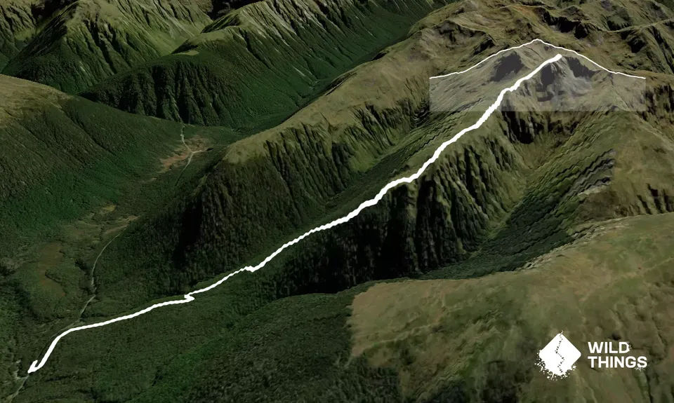
Start by crossing the road from the DOC Deer Flat campsite and head onto the signposted Foleys Track. You'll begin with nice moderately technical trail ascending through amazing beech forest. Perfectly runnable. Smell that honeydew! As the elevation climbs so does the steepness - nothing too frightening but its once of those ascents where you have to decide whats more efficient, a fast walk or a slow run with the odd breather.
Eventually you'll reach the bushline at around 1300m and from there you really start to soak up the views, which just keep improving as you climb higher. The route to the summit is fairly obvious, mostly on the ridgline past the odd tarn and plenty of tussockland. The poles stop a short way above the bush, which could make navigation a little tricky in cloud - you will want a gpx or map and compass if you're doin it with low visibilty.
The summit is a place to linger, its just so good to be high on the hills and these are some of the best you'll find anywhere.In clear weather you'll spot a couple of other Trail Directory Routes in the distance, such as Mt Haast and the Lewis Tarns. Once you've got your fill retrace your steps back to the car, unless you are super intrepid and want to take the Zampa Tops route and come out down the St James Walkway - but that's a whole other kettle of fish and for the true adventure runners.
When you get back to the car at Deer Flat there's always the Rolleston Pack Track to add on if you want a little extra mileage on the day as well.
Trail Community
Features of interest
Stunning views around the Lewis Pass Mountains
Make Up of Run
Untracked / Route only: 20%
Technical Single Track: 60%
Moderate Single Track: 20%
Route Data
Reviews:
Photos:
Your Trail Wishlist
All the runs that are on your To Do list (no limit).
Add to wishlist view wishlistWild Explorers
I did it!-
Access
Trail head is signposted on the side of SH7 just over from Deer Valley campsite
Parking at the campsite. Please be respectful to campers, etc
14 km
11 minutes
No
No
-
Staying Safe
Moderate.
Its well marked in the bush and there are poles on the tops, but take a GPX and map just in case you are clagged out up high
Non-existent.
Waterproof leggings, Thermal leggings, Short-sleeved thermal top, Long-sleeved thermal top, Seam-sealed waterproof jacket, Windproof jacket, Gloves, Beanie/thermal headwear, Personal Locator Beacon (PLB), Whistle, First aid kit, Extra food for emergencies, Survival bag, Cellphone, Compass, Map, Headtorch and spare batteries, Crampons / microspikes (for winter conditions), Gaiters.
There's a few tarns on the tops that are likely drinkable, but probably best to bring enough from home
Being high tops this is not a run for poor winter conditions
Usual caution and care with weather forecasts and seasonal snow
-
Sponsor this trail