Wild Things - New Zealand's trail running community
New Zealand's trail running community

Login


don't have an account?

Waharau Ridge Gutbuster, Auckland

Trail Directory proudly supported by Further Faster

Update Your Header Picture

Waharau Ridge GutbusterBeginner

Submitted by Nikki Newham

Info Info
Map Loading

Trail Information

11.30km

635m

630m


Auckland

Clevedon

Front country - easily accessible

Loop

Undulating, some big hills

Native bush

Beginner

2:30 (Slow)
2 (Moderate)
1:30 (Fast)

-11.1%

+11.2%

The Waharau Ridge Track has reopened in late 2021 with significant Kauri Dieback upgrades, particularly on the north side of the loop (quite a few stairs)

Download PDF Guide

Fastest Known Times (FKTs)

Please set your gender to see your position on the FKT leaderboards.

Men

Women

Show more

Filter FKTs

The more , the harder the FKT will be to beat. Learn about Fastest Known Times.

Missing your time?

Register or login as a VIP and get yourself on the FKT leaderboard!

Register Now

Description

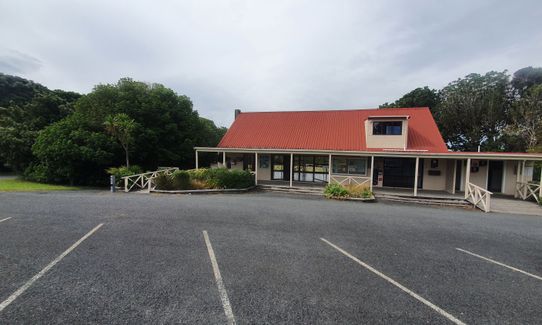
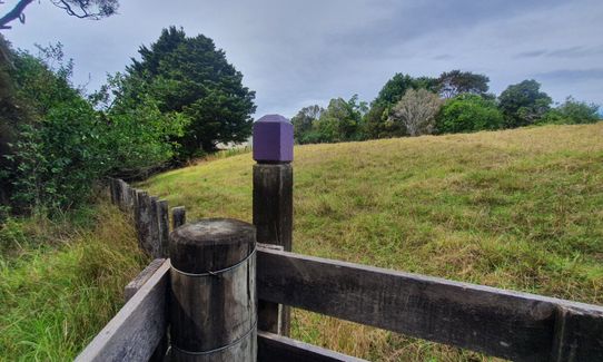
From the sealed carpark at the Information Building head left around the back of the building and look for the purple track marker. Follow the purple track through the Puriri Grove and around the edge of the park toward the camping area.

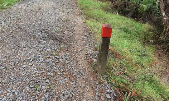
Head toward the top of the picnic area where there are toilets and water. Stop at the footwash station and give your shoes a good scrub and disinfect. Once through the footwash station head up the 4 wheel drive track following the red marker poles. There are a couple of other tracks still closed (upper and lower link tracks) so be aware for barriers and signage.

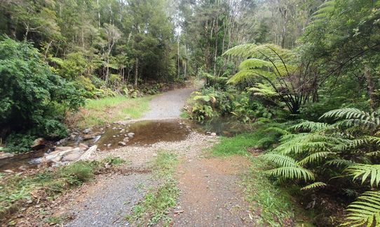
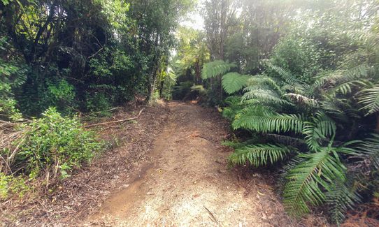
Follow the track onwards and upwards. There's a small ford to cross around 3km in, hop the stepping stones or embrace the cooling from wet shoes, it's pretty benign in good weather, caution is required if it's been very wet.

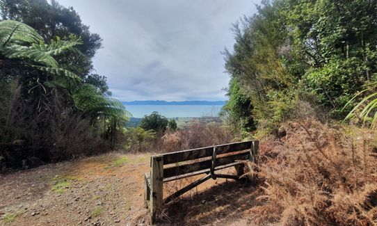
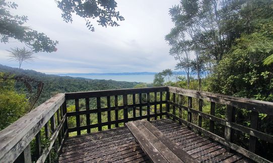
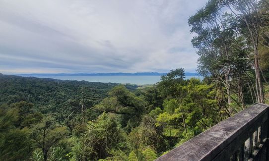
Keeping going up, it's steep in places but the views are worth it. Somewhere about the 6km mark, you are near the ridge, there's a great viewpoint up here, definitely worth a stop.

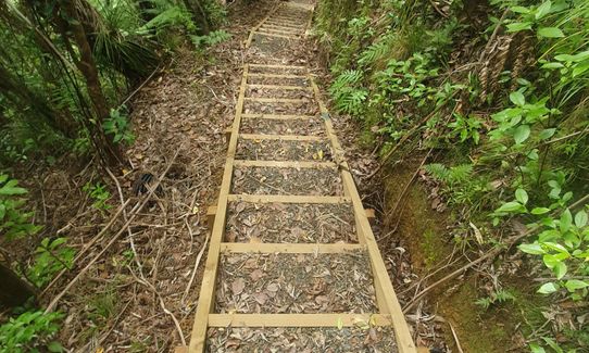
Carrying on the ridge track which undulates for a few km, you'll come to what was a track junction - there is now only one option, to head down. Enjoy the downhill, the steps and a couple of viewing spots along the way.

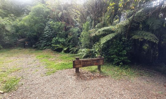
Towards the bottom of the hill you'll come across a closed gate, follow the track round to the left even though you can see a track marker past the locked gate. The track has been rerouted due to Kauri Dieback upgrade work.

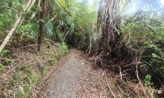
Head downhill, stay on the track that will turn into green track markers, hang a right just after the wooden footbridge back towards the carpark. The trail here is very pretty running through the established bush.

Once you exit through the footwash station, turn left and head uphill. The carpark is only about 200m away!


Trail Community

Find people who are interested in this run.

You must register or login to view this content.


Make Up of Run

Untracked / Route only: 0%

Technical Single Track: 0%

Moderate Single Track: 0%

Easy Single Track: 40%

Farm Road / 4WD Track: 60%


Route Data

Reviews:

You must register or login to view this content.


Overlapping Runs

The following trails overlap with this run to some degree. You may wish to combine them but please note that to qualify for FKTs on these runs you should record a separate Strava activity for each

Hunua Heaven

Hunua Heaven

Length: 18.90km


Photos:

You must register or login to view this content.

Your Trail Wishlist

All the runs that are on your To Do list (no limit).

Add to wishlist view wishlist

Your Trail Dreamlist

The runs you most want to do (limited to 10).

Add to dreamlist view dreamlist

Wild Explorers

I did it!
  • Access

    Start is at Waharau Regional Park information Bbilding, just next to the sealed carpark. There is parking further into the park however this trail entry starts with the purple track just behind the information building.

    Plenty of parking in the park, either at the first carpark next to the Information building or further into the park. Waharau Regional Park is about 1 hour from the Howick area of Auckland if you take the coast road. From Clevedon head towards Kawakawa Bay, then on past the Orere Point turnoff. Waharau is around 10mins driving time past the Tapapakanga Regional Park turnoff. From other Auckland regions it may be quicker to take the Southern Motorway, then SH2, then Mangatangi and Kaiaua.

    37 km

    39 minutes

    No

    No

  • Staying Safe

    Easy.

    All other tracks that used to connect to the Waharau Ridge Track are now closed. There are barriers and signage so it should be obvious where not to go.

    Patchy.

    Short-sleeved thermal top, Windproof jacket, Whistle, First aid kit, Extra food for emergencies, Cellphone, Map.

    There is a water tap near the toilets at the top end of the picnic area, just before you head uphill on the red poled track.

    Can be windy and cold at the ridge at any time of year. Track upgrade work has removed any muddy parts.

  • Sponsor this trail

    If you are interested in learning about sponsorship opportunities, please get in touch below:

    Submit

Got a favourite trail? Tell us about it.

Share the love and add your favourite trail(s) to our growing trail directory.

Submit A Trail

Become a member today

Start enjoying the many benefits to becoming a member of our thriving community.

Become a member

Great brands at great prices with our VIP member's discount

Stay up to date

Sign up to our newsletter for latest offers and trail guides

Share this trail with a friend:

VIP Membership

Please register as a VIP or login to your VIP account to view this content.

Cancel Login Register

Membership Required

You can see up to three trail guides without being logged in but after that we require you to be logged in to your Free or VIP account. If you don’t yet have an account you can register here.

Login Register