Last Updated: 21st Sep 2023

Experienced

Save Trail Save

I've done it Done

Wangapeka via Biggs Tops

Karamea, West Coast

Submitted by Mike McManaway

Last Updated: 21st Sep 2023

Experienced

Save Trail Save

I've done it Done

Grunt Factor: 104 ?

Gnarl Factor: 45 ?

61.0km

2900m

2650m

1335m


Login as a VIP to see driving directions, distance and time.

Trail Map

Type of Run

Back country - remote

Point to Point (one way)

Very hilly

Native bush

Open ridges/tops

Run Makeup

40%
30%
30%

Easy Single Track

Moderate Single Track

Technical Single Track

Average Uphill Gradient: +9.6%

Average Downhill Gradient: -8.8%

Trailhead

Login as a VIP to see the trailhead information.

Estimated Times to Run

18:00

Slow

14:00

Moderate

11:00

Fast

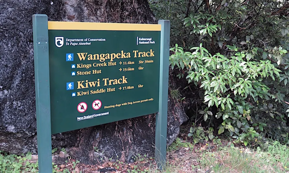
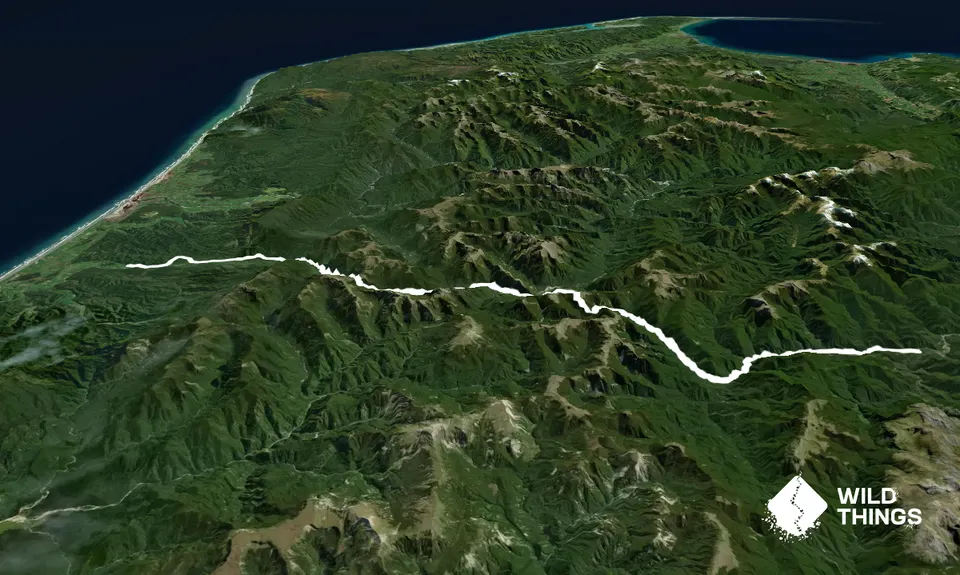
Normally tramped East to West, however as a one day run its easier to get an early morning start from Karamea and finishing up on the eastern end means a progressively better maintained trail. Also more huts in case of any delay i.e. it goes without saying that you'll need gear to survive at least one night stranded out and of course take an EPB or satellite messenger.

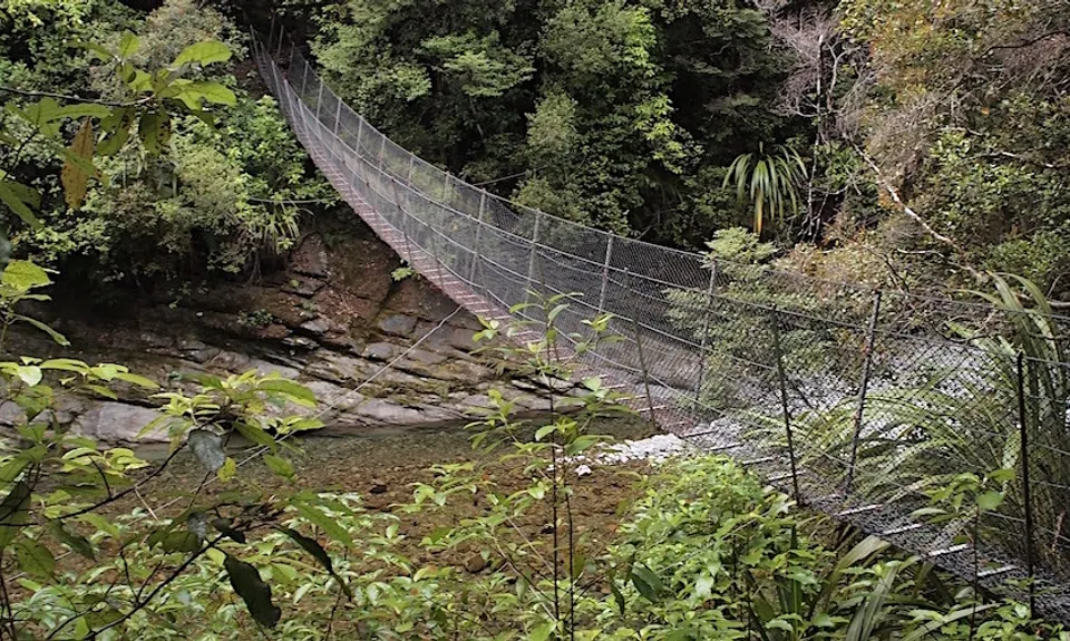
From the Karamea side all the way to Stone Hut is classified as a DOC "route" i.e. suitable for people with high-level backcountry (remote area) skills and experience. Navigation and survival skills are required. Expect unbridged streams and river crossings. Whereas from Stone Hut to Rolling Junction the trail follows the Wangapeka River and is managed as a tramping track. This means the vegetation is regularly cut, and all major river and stream crossings are bridged.

If fast walking but little running takes say 14 hours then (very approximately) Western Car park to Belltown hut: 2 hrs, Belltown to Taipo hut: 3.5 hrs, Taipo to Trevor Hut: 2 hrs, Trevor to Wangapeka Saddle: 2.5 hrs, WPS to Kings Creek Hut: 2 hrs, Kings to Rolling Pin carpark 2 hrs. This GPX track log assumes you'll choose fine weather and want to take the "short cut" over Biggs Tops but of course in poor viz the low route from Trevor Carter hut to Wangapeka Saddle is the better option.

Gold was discovered in the Wangapeka valley in 1859 leading to the building of the route between 1862 and 1899 The Wangapeka traverses Kahurangi National Park, crosses two saddles, each of over 1,000 m, and travels through the beautiful beech-forested valleys of the Wangapeka, Karamea, Taipo and Little Wanganui rivers. Although the area attracted gold hunters for about 70 years, few fortunes were made. The first pastoral licence for sheep grazing in the Wangapeka valley was granted in 1851. By the late 1860s, sheep had reached the alpine grasslands of the Wangapeka tops. Grazing attempts were abandoned after 1940 because of fierce competition for feed from deer. The 1929 Murchison earthquake caused severe damage to sections of the Wangapeka Route. These sections were rebuilt during the 1930s depression including the Cecil Kings Hut.

21 km

24 minutes

Unknown

No

Hard.

Non-existent.

Thermal leggings, Lightweight fleece top, Long-sleeved thermal top, Seam-sealed waterproof jacket, Gloves, Beanie/thermal headwear, Personal Locator Beacon (PLB), Whistle, First aid kit, Extra food for emergencies, Survival bag, Compass, Map, Headtorch and spare batteries.

Pretty dry from Trevor Carter Hut up to Biggs Tops

Needs a long summer day and even then at least a 4am start.

Have a backup plan if Biggs Tops is clouded over.

Beforehand stay at the Last Resort in Karamea. Its a must do!

You and Wangapeka via Biggs Tops

As a VIP member you can record private notes for this trail, see all of your times and more.

Register Now

Already have an account? Login now

Trail Reviews

Fingers crossed this get some repeats but if so please ignore the fake "moving" time showing in error above because my actual time was 14 hours. In saying that I carried a lightweight sleeping bag "in case" and walked all of it so doable in a day.

Mike McManaway

September 10, 2022

Well yet to run or hike the whole thing however hiked in from Eastern side as far as Trevor Carter following this route. Just a quick note that whoever set this trail over Biggs Tops is incredibly fit....the descent for us, ascent on this is seriously steep so not for the faint hearted! Although would definitely recommend going up it than down as felt pretty sketchy in parts.

Fabulous valley though and gorgeous trails, particularly loved the Charles King hut to Wangapeka saddle section. If allergic to wasps take your meds as unfortunately more than you'd like to see buzzing around but far from Nelson Lakes volumes for us and easy enough to navigate around. Enjoy!!

Natasha Furness

January 5, 2022

Login to submit a review

Trail Running Community

Find people who are interested in or have completed this trail run.

You must register or login to view this feature.

Register Now

Other trails nearby
Heaphy West to East

Heaphy West to East

Length: 78.4km

Level: Experienced

Heaphy Hut Out & Back

Heaphy Hut Out & Back

Length: 33.2km

Level: Beginner - Intermediate

Find more trails and peaks nearby