Last Updated: 21st Sep 2023
No More Beersies
Submitted by Matt Doherty
Last Updated: 21st Sep 2023
Open
Grunt Factor: 17 ?
Gnarl Factor: 29 ?
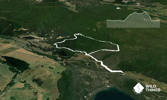
12.0km
370m
370m
872m
Last Updated: 21st Sep 2023
Submitted by Matt Doherty
Last Updated: 21st Sep 2023
Open
Grunt Factor: 17 ?
Gnarl Factor: 29 ?
12.0km
370m
370m
872m
Front country - easily accessible
Combo
Undulating, small hills only
Dog Friendly
Native bush
Easy Single Track
Moderate Single Track
Technical Single Track
Average Uphill Gradient: +7.7%
Average Downhill Gradient: -8.3%
VIP Feature: Send this route to your Garmin account so you can follow the course on your Garmin device.
Login as a VIP to see the trailhead information.
1:40
Slow
1:10
Moderate
0:50
Fast
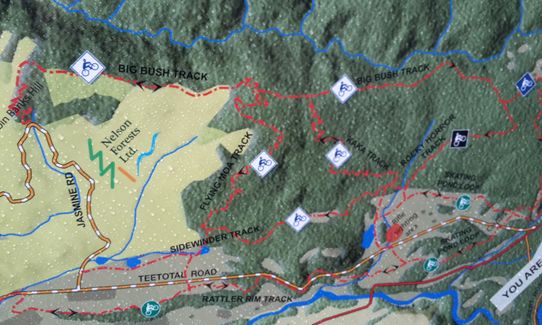
No More Beersies - Teetotal Flats Recreation Area.
This network of tracks is open to walkers, runners, mountain bikers, hunters etc. Nice mix of river flats & native bush, easy climbs and rocky descents.
The route is a clockwise loop using the Skating Pond, Kaka, Sidewinder, Flying Moa, Big Bush, Rocky Horror & Skating Pond trails
From the campsite enter the marked trail after checking the big map at the trail head. All track junctions are well marked.
Pick up the Skating pond loop (you want to be on the hill side not the river side of this looping track) and follow on the cruisy river flats to the Kaka junction.
Turn right and briefly follow Kaka until you hit Sidewinder where you turn left.
Follow Sidewinder to the intersection with Flying Moa. Turn right here & follow Flying Moa to the top of the hill.
At the top of the hill turn right again and follow Big Bush as it undulates for a couple of kms.
Ignore the Duck Down Track to your left, continue on & then head down Rocky Horror for the highlight of the run. This is a moderately steep gully with lots of loose rock and a few slick clay sections, before easing back to the river flats and back to the Skating Pond Loop where you turn left & head back to the start.
There is an ice skating pond if you are here in the winter
If you know of any public toilets near the trail start or on the route, please login and then let us know so we can update this section.
Parking at the DOC site at the start
2 km
2 minutes
Yes
No
Easy.
Take a photo of the map on the board at the beginning
Very patchy.
Short-sleeved thermal top, Windproof jacket, Gloves, Beanie/thermal headwear, Whistle, First aid kit, Extra food for emergencies, Cellphone, Map
Water at the start although it does say to boil for 3 mins!
We arrived shortly after cyclone Gita had been around which meant no mountain biking due to lots of wind damaged trees plus the trails being way to wet to ride.
I have guessed at the expected normal run times due to the difficult conditions when running. There were around 20 trees blocking tracks, ankle deep mud in some spots and knee deep water in others. It took me 1.37 hrs where I would expect just over an hour under normal conditions. Probably why It was still the best run I'd done in a while :)
Mountain bikers, hunters.
Fastest Known Times (FKTs)
You and No More Beersies
As a VIP member you can record private notes for this trail, see all of your times and more.
Already have an account? Login now
What a great route! Lovely combo of open grassy stuff & beaut beech forest, mellow & gnarly trail. Trail markings/junctions a little vague in a couple of places but the RunHunters app was really useful for staying on the right path. A wee gem, recommended.
November 19, 2020
MD
I did this run just after Gita had been through so have had to estimate the running times due to the abnormal track condions. Lots of trees down, lots of mud, and thigh deep water in some places. The Rocky Horror downhill is a (suicidally slippery) gem. Am looking forwards to returning next summer, will take the bike too.
April 17, 2018

Length: 38.3km
Level: Intermediate - Experienced
Send to your phone
Scan the below QR code to open this trail on your phone.

Tip: position the QR code in your phone camera screen.


