Last Updated: 30th Dec 2024
Hacket Hut & Whispering Falls
Last Updated: 30th Dec 2024
Open
Grunt Factor: 27 ?
Gnarl Factor: 48 ?
12.9km
380m
390m
292m

Last Updated: 30th Dec 2024
Last Updated: 30th Dec 2024
Open
Grunt Factor: 27 ?
Gnarl Factor: 48 ?
12.9km
380m
390m
292m
Back country - remote
Out and Back
Undulating, small hills only
With permit
Native bush
Riverside
Gravel Road
Easy Single Track
Moderate Single Track
Technical Single Track
Average Uphill Gradient: +7.4%
Average Downhill Gradient: -7.3%
VIP Feature: Send this route to your Garmin account so you can follow the course on your Garmin device.
Login as a VIP to see the trailhead information.
2:30
Slow
1:45
Moderate
1:15
Fast
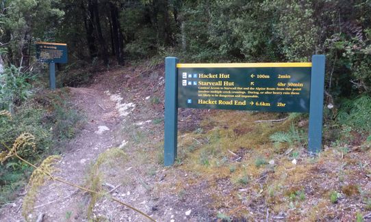
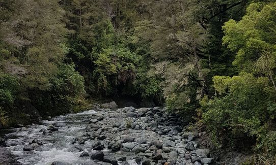
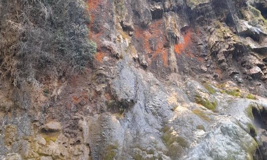
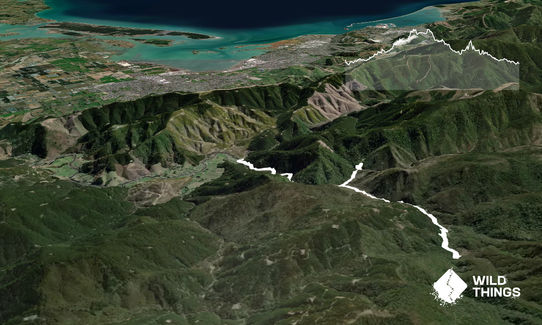
From the picnic area, cross the wooden bridge and follow the well sign-posted 4 wheel drive road (initially) and single track to Hacket Hut. The trail is rocky and rooty in most parts with several short detours due to washouts. You can take a side detour to Whispering Falls (1km each way). On this detour there is a river crossing where the bridge has been washed out so you may get wet feet and this is not advised if the river is in flood or flowing swiftly after rain. The track to Whispering Falls becomes a bit of an uphill scramble near the Falls. The Falls are spectacular and well worth the detour if there has been rain fairly recently but disappointing if the weather has been dry for a long time!
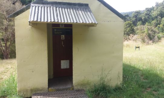
The Hacket Hut is a 6 bunk hut with a toilet (long drop) and a log burner in a clearing with a picnic table near a river. I didn't notice if there was a water supply at the hut but I'm pretty sure you can drink from the river as it looked absolutely pristine.
Waterfalls, swing bridges, disused Chromite mine, Back Country hut (Hacket Hut).
If you know of any public toilets near the trail start or on the route, please login and then let us know so we can update this section.
Parking is available and plentiful at the picnic area at the end of Hacket Creek Road.
17 km
26 minutes
With Permit
No
Moderate.
Well signposted trail.
Non-existent.
Seam-sealed waterproof jacket, Gloves, Beanie/thermal headwear, Personal Locator Beacon (PLB), Whistle, First aid kit, Extra food for emergencies
Most of the trail is riverside and I believe the water is usually potable.
In a valley so in winter there wouldn't be much sun on the trail and it could be freezing. Not recommended to cross the river after heavy rain. Trail has had numerous washouts in the past due to rain so caution advised if running in very rainy conditions or after heavy falls. No cell phone reception so care needed especially if running solo. Track was fairly well-populated in December when I ran it but not sure about the likelihood of meeting people on it during the winter period.
Washouts, uneven terrain, remote (no cellphone reception).
Trail Legend
Login as a VIP to become a Trail Legend. Learn about Trail Legends.
Fastest Known Times (FKTs)
Make sure you take the detour to Whispering Falls to get a valid FKT!
You and Hacket Hut & Whispering Falls
As a VIP member you can record private notes for this trail, see all of your times and more.
Already have an account? Login now
Much more runable (in spots) than I anticipated. Very nice trail that deteriorates in quality a bit the higher you go. Side trip to Whispering Falls is definitely worthy of an explore. Make sure you follow the track to the top. If I wasn't following the GPX, I would have bailed early, thinking I was at them. You get in a stream crossing too which adds to the adventure.
December 25, 2021
Take care in muddy weather as there's a tricky little slip to cross but guess Doc will fix it asap. Really loved the waterfall- see photo.
December 3, 2021
A very enjoyable trail beside the river, tho it was too high to cross to go and see the falls after recent heavy rain. Much nicer temperatures for running this valley in April than when I came up here in January. Beware you don't take a right after the last wee stream crossing like I did and started heading up a 4wd track. Keep left instead. Definitely no water at hut but river close by.
April 2, 2021
An easy cruise apart from the washed out bit where the track detours through a forest with not much signage. I ran on from the Hacket Hut to Browning Hut which is quite steep and technical with roots everywhere, then returned to the Hacket Carpark.
January 18, 2018
These overlap with this trail to some degree. You may wish to combine them but please note that to qualify for FKTs on these runs you should record a separate activity for each.
Send to your phone
Scan the below QR code to open this trail on your phone.

Tip: position the QR code in your phone camera screen.


