North Mavora Lake - Carey's Hut returnBeginner - Intermediate
Submitted by Katy Barker
Back country - remote
Out and Back
Undulating, small hills only
Native bushBeachLakesideOpen tussock/grasslands
Beginner - Intermediate
3:30 (Slow)
2:30 (Moderate)
1:45 (Fast)
-2.3%
+2.3%
Fastest Known Times (FKTs)
Men
There are currently no male FKTs for North Mavora Lake - Carey's Hut return.
Women
There are currently no female FKTs for North Mavora Lake - Carey's Hut return.
Filter FKTs
The more , the harder the FKT will be to beat. Learn about Fastest Known Times.
Description
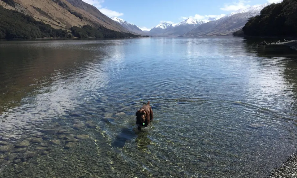
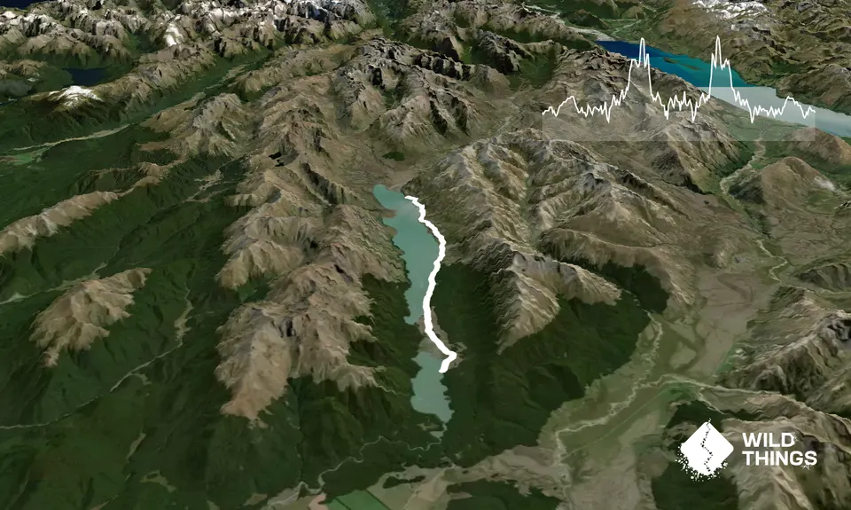
Mavora is a great spot to take your favourite furry four-legged training partner - dogs are welcome in Mavora Lakes Conservation Area so long as under control (or leashed in the camping areas). Mavora Lakes are two beautiful lakes surrounded by mountains, the smaller South Lake and larger North Lake. Mavora Lakes can be linked to the Greenstone track via a 50km track with huts along the way. This run is an out-and-back starting at Mavora and running in to the first hut along this track - Carey's Hut - and then returning to Mavora Lakes.
As noted above, start wherever you like along Mavora Lakes Road depending on how long you want to run. If you start from South Lake camping area it's 25.6km return. If you do this, the first part of your run will be along a gravel road. If you do have your dog friend with you, either leash them or have them under control as (depending on the time of year) the area can be popular with campers, anglers, 4WDers etc so there can be a bit of traffic on the road.
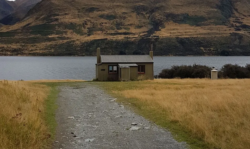
You start the track proper at the end of Mavora Lakes Road, and you will then be running up the east side of North Mavora Lake. Navigation is easy - keep the lake to your left on the way up, and the right on your way down! The track is a 4WD track, parts of which are more runnable than others - stony in places, paddocks in others, a few stream crossings. Don't expect to set any land speed records. I went shortly after some rain so there were some massive puddles totally covering the track in places which occasionally required a bit of going slightly off track to dodge round them (or wading through!). This might be totally different if you went in summer after a dry spell. If you think you might be doing some puddle-dodging, then you might be grateful to be wearing leggings to protect your legs from scratchy matagouri. There's a couple of spells where the 4WD track just takes you along the pebbly beach - not too bad to run on especially if you can run in the 4WD vehicle tracks. I turned around at Carey's Hut but you could continue past there if you wanted a longer run. I read on the DOC page that the track forks and gets a bit trickier after that, so would pay to do a bit of research beforehand if you thought you would want to go further.
Trail Community
There are currently no members to show for this trail.
Features of interest
If you're a die-hard Lord of the Rings fan this is the run for you... Nen Hithoel was filmed along the east side of North Mavora Lake.
Make Up of Run
Farm Road / 4WD Track: 80%
Gravel Road: 20%
Route Data
Reviews:
Photos:
Your Trail Wishlist
All the runs that are on your To Do list (no limit).
Add to wishlist view wishlistWild Explorers
I did it!-
Access
Turn off SH94 at the signs for Mavora Lakes onto Centre Hill Road. After about 16km you then turn onto Mavora Lakes Road which takes you to the Mavora Lakes Conservation Area. Mavora Lakes Road continues past the South and North Lakes and you could start your run wherever you liked along the road. I started from the South Lake camping ground area on Mavora Lakes Road which is clearly marked by DOC signs - but if you wanted to shorten the run to more like 20km return then drive right to the end of the road which is obvious.
Note that Centre Hill Road and Mavora Lakes Road are both gravel - so you've got about 40km of driving on good gravel road. There is almost no cellphone reception along the access roads, and certainly none in the Mavora Lakes Conservation Area, so do your planning before you turn off SH94.No public transport. There is parking at various spots along Mavora Lakes Road at day use areas, camping areas and at the end of the road.
39 km
37 minutes
Yes
No
-
Staying Safe
Easy.
Non-existent.
Thermal leggings, Short-sleeved thermal top, Long-sleeved thermal top, Seam-sealed waterproof jacket, Gloves, Beanie/thermal headwear, Whistle, First aid kit, Extra food for emergencies, Survival blanket, Cellphone, Map, Headtorch and spare batteries, Crampons / microspikes (for winter conditions), Gaiters.
There is plenty of water but it must be treated - better to carry your own.
Elevation is 600m so if snow has recently fallen to low altitudes in Otago/Southland, it would be advisable to check in with DOC about the status of the access roads.
Sandflies! Insect repellent would be a good call.
Small stream crossings along the way. It MIGHT be possible to keep your feet dry but I wouldn't know as I epically failed at this...
It is quite isolated and you might be lucky enough to have the track to yourself - so either take a mate or tell someone beforehand where you are going, and take enough supplies that you could look after yourself for the night if you did turn an ankle etc. Expect it to be cold overnight given the elevation! Note that if you are needing to tell someone what your intentions are, you'll need to do that before you turn off SH94 as there is no cellphone reception at Mavora Lakes and only extremely patchy along Centre Hill Rd/Mavora Lakes Rd. - Blog Posts and Articles
-
Sponsor this trail