Last Updated: 13th Feb 2024

Experienced

Save Trail Save

I've done it Done

Sebastopol Traverse - sky run

Sebastopol Ridge

Red Tarns Track

Last Updated: 13th Feb 2024

Experienced

Save Trail Save

I've done it Done

Grunt Factor: 21 ?

Gnarl Factor: 75 ?

5.7km

820m

820m


Login as a VIP to see driving directions, distance and time.

Trail Map

Type of Run

Front country - easily accessible

Combo

Mountainous

Native bush

Open tussock/grasslands

Open ridges/tops

Run Makeup

50%
20%
30%

Easy Single Track

Technical Single Track

Untracked / Route only

Average Uphill Gradient: +28.7%

Average Downhill Gradient: -28.8%

Trailhead

Login as a VIP to see the trailhead information.

Estimated Times to Run

Not suitable

Slow

3:00

Moderate

1:30

Fast

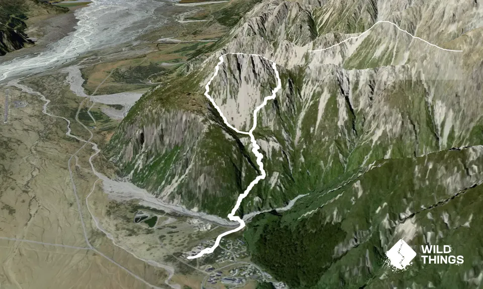
Start from the dead end at Sebastopol Drive. Follow DOC signs to Red Tarns track. Cross the footbridge across Black Birch Stream. Follow the DOC track to Red Tarns. It is about 1km and 300m ascent up stairs with occasional low gradient sections.

Once at Red Tarns follow the unmarked but well worn route up to the saddle amongst low native vegetation. Continue up the ridge towards the summit of Sebastopol on steep sections made up of scree up to the summit at pt. 1468. Follow the ridgeline until you see a rock with a hole in it. Turn right and follow the scree fan down towards the valley floor. To the right is a gap in the vegetation and follow goat tracks to cut back under the Sebastopol Summit. Descend scree slope to meet back at the Red Tarns track and retrace steps to where you started.

This trail includes the peak Sebastopol .

Summit of Sebastopol provides 360 degree views of Aoraki/Mount Cook National Park

Parking at the start of the trailhead.

1 km

5 minutes

No

No

Hard.

There are two key turning points in the route. One - after Sebastopol summit you traverse the ridge and need to find an exit point down into the valley. A key feature is a rock with a hole in it, above an obvious scree fan. Two - you need to sidle to the right in order to cut back under Sebastopol Ridge. There is a gap in vegetation you can see to the right. Follow one of the many goat tracks that lead you to this gap. Once through the gap, it is wide open scree fan to return back to the Red Tarns track.

Perfect throughout.

Lightweight fleece top, Long-sleeved thermal top, Seam-sealed waterproof jacket, Windproof jacket, Gloves, Beanie/thermal headwear, Personal Locator Beacon (PLB), Whistle, First aid kit, Extra food for emergencies, Survival bag, Survival blanket, Cellphone, Map, Headtorch and spare batteries, Crampons / microspikes (for winter conditions)

No water along the route.

Not advised during winter as there is snow. Very exposed to cold winds and rain at certain times of the year.

The ridgeline is very exposed. Move carefully.

You and Sebastopol Traverse - sky run

As a VIP member you can record private notes for this trail, see all of your times and more.

Register Now

Already have an account? Login now

Trail Reviews

Be the first to submit a review for Sebastopol Traverse - sky run !

Login to submit a review

Trail Running Community

Find people who are interested in or have completed this trail run.

You must register or login to view this feature.

Register Now

Overlapping Trails

These overlap with this trail to some degree. You may wish to combine them but please note that to qualify for FKTs on these runs you should record a separate activity for each.

Two Tarns Stepathon

Two Tarns Stepathon

Length: 14.2km

Level: Intermediate

Red Tarns

Red Tarns

Length: 3.5km

Level: Beginner

Red Tarns & Governors

Red Tarns & Governors

Length: 4.4km

Level: Beginner - Intermediate

Two Tarns Stepathon

Two Tarns Stepathon

Length: 14.2km

Level: Intermediate

Red Tarns

Red Tarns

Length: 3.5km

Level: Beginner

Red Tarns & Governors

Red Tarns & Governors

Length: 4.4km

Level: Beginner - Intermediate

Two Tarns Stepathon

Two Tarns Stepathon

Length: 14.2km

Level: Intermediate

Red Tarns

Red Tarns

Length: 3.5km

Level: Beginner

Red Tarns & Governors

Red Tarns & Governors

Length: 4.4km

Level: Beginner - Intermediate

Other trails nearby
Hooker Hut

Hooker Hut

Length: 8.9km

Level: Beginner - Intermediate

Point at the Keas

Point at the Keas

Length: 3.9km

Level: Beginner

Husky Flat via Blue Lakes

Husky Flat via Blue Lakes

Length: 11.1km

Level: Intermediate

Mt Cook Village & Hooker Valley

Mt Cook Village & Hooker Valley

Length: 16.0km

Level: Beginner

Find more trails and peaks nearby