Last Updated: 22nd Sep 2025
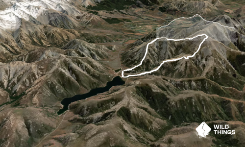
Red Hill,Mt Lyndon and Cloudy hill via Coleridge pass
Last Updated: 22nd Sep 2025
Open
Grunt Factor: 79 ?
Gnarl Factor: 110 ?
20.2km
2045m
2015m


Last Updated: 22nd Sep 2025
Last Updated: 22nd Sep 2025
Open
Grunt Factor: 79 ?
Gnarl Factor: 110 ?
20.2km
2045m
2015m
Back country - remote
Loop
Undulating, some big hills
Open tussock/grasslands
Open ridges/tops
Untracked / Route only
Average Uphill Gradient: +20.40%
Average Downhill Gradient: -20.10%
VIP Feature: Send this route to your Garmin account so you can follow the course on your Garmin device.
Become a VIP Member to see the trailhead information.
8:00
Slow
6:00
Moderate
4
Fast
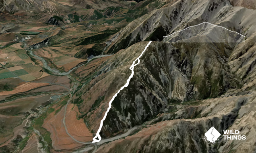
Drive your car all the way to the turnoff for Porters Alpine Lodge. You won’t be able to go any further than that, as there’s a closed gate. Leave your car on the side of the road. Orient yourself to where you need to go. And an important tip: there's a good track on the true right side of the creek; don’t try to find anything on the left side. So, ford the Porters River and continue along the nice track. Somewhere roughly halfway between the parking area and Coleridge Pass, the track disappears and you’ll need to find your own way up the valley.
Shortly before reaching Coleridge Pass, you can follow the ridge that leads towards Red Hill, or you can also head all the way to the Pass and then climb up from there. This long ascent is rewarded with a view of Lake Coleridge.
After reaching Red Hill, turn left and continue across points 1488 and 1494 (the descent from 1494 is a bit tricky) and then to 1390, eventually reaching Mt Lyndon. If you want to see Lake Lyndon, you’ll need to descend a little bit to the east.
After that, a tougher section follows between Mt Lyndon and point 1456: first a steep descent, then a sharp climb up a scree slope. (Not recommended doing this part if it's rainy or icy.)
From point 1456, continue easily via point 1345 to the summit of Cloudy Hill. Enjoy the views, then return the same way back to point 1456. From there, descend back to Porters River and follow the same track you used in the morning to get back to your car.
The trek is a good choice if you don't want to apply for a permit.
This trail includes the peaks Red Hill - Craigieburn, Mount Lyndon and Cloudy Hill.
Lake Coleridge, Lake Lyndon, mountains around.
None.
There are a few parking spaces available, or you can park at the lower carpark and run to the start.
13 km
18 minutes
Unknown
No
Moderate.
Generally good.
Waterproof leggings, Short-sleeved thermal top, Windproof jacket, Gloves, Beanie/thermal headwear, Personal Locator Beacon (PLB), Whistle, First aid kit, Extra food for emergencies, Survival bag, Survival blanket, Cellphone, Map, Headtorch and spare batteries, Crampons / microspikes (for winter conditions), Gaiters
No water once you start climbing.
It's not recommended to attempt the whole loop in winter.
Steep descents.
Do you have a suggestion on where to go afterwards for the best coffee / cake / breakfast / brunch / beer?
Fastest Known Times (FKTs)
You and Red Hill,Mt Lyndon and Cloudy hill via Coleridge pass
As a VIP member you can record private notes for this trail, see all of your times and more.
Already have an account? Login now
These overlap with this trail to some degree. You may wish to combine them but please note that to qualify for FKTs on these runs you should record a separate activity for each.
Send to your phone
Scan the below QR code to open this trail on your phone.

Tip: position the QR code in your phone camera screen.
Plan smarter, stay motivated, track your progress, and unlock the full Wild Things experience — while saving along the way.