Last Updated: 17th Oct 2025
Ben Lomond- Ptarmigan Ridge Loop
Ben Lomond- Ptarmigan Ridge Loop
Last Updated: 17th Oct 2025
Open
Grunt Factor: 36 ?
Gnarl Factor: 49 ?
12.5km
1065m
1065m

Last Updated: 17th Oct 2025
Ben Lomond- Ptarmigan Ridge Loop
Last Updated: 17th Oct 2025
Open
Grunt Factor: 36 ?
Gnarl Factor: 49 ?
12.5km
1065m
1065m
Back country - remote
Loop
Very hilly
Lakeside
Open tussock/grasslands
Open ridges/tops
Easy Single Track
Moderate Single Track
Technical Single Track
Average Uphill Gradient: +17.10%
Average Downhill Gradient: -17.10%
VIP Feature: Send this route to your Garmin account so you can follow the course on your Garmin device.
Login as a VIP to see the trailhead information.
5:00
Slow
4:00
Moderate
3
Fast
We are eager to expand our Trail Running Directory in the UK and Ireland. For a limited time, if you submit any trail in the UK and Ireland and we publish it, we'll double the credit you receive! Submit a new trail now.
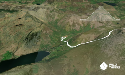
Ben Lomond (974m) is the southernmost of the Scottish Munros. Its accessibility and tourist trail make it one of the most popular hikes in Scotland. This route recommends the ascent via the tourist trail and a descent down the somewhat more technical but spectacular Ptarmigan Ridge.
Starting at the car park, initially you climb up through an oak forest until you break out into the open. Views of Loch Lomond are immediately impressive. Ascend the Ben via the National Trust developed trail, but be sure to stick to the wide well defined path as erosion has been a problem in the past. The higher you go the more expansive the views become, assuming you have good visibility
The trail is more steady than steep, with only the top section providing any risk of exposure. Enjoy the 360 degree summit view, its a place to linger Loch Lomond, The Cobbler, The Trossachs and much more to feast your eyes on.
The Ptarmigan Ridge route is less developed but still very well defined for the descent. Initially steep and almost a bit scrambly it soon steady's out to a spectacular and enjoyably trail as it winds its way steadily back down the the loch. Its a fairly long way and most legs will feel it by the bottom.
Return to the carpark along forest trails and maybe consider a dip in the water if you need a cool down.
This trail includes the peak Ben Lomond.
Ben Lomond is one of the most popular munros. Expect lots of company! Great views all day if the weather plays ball.
Public toilets at the carpark only.
Carparking is at the Rowardennan car park. It can be busy here and there is an overflow park. Aim to start early to get best parking options. Note there is a fee. There is no public transport, you'll need a vehicle to get in there and take care on the narrow road.
Unknown
No
Moderate.
You can't really go wrong but take a map and GPX to be sure of things if its clagged out
Patchy.
Waterproof leggings, Thermal leggings, Lightweight fleece top, Short-sleeved thermal top, Long-sleeved thermal top, Seam-sealed waterproof jacket, Gloves, Beanie/thermal headwear, Personal Locator Beacon (PLB), Whistle, First aid kit, Extra food for emergencies, Survival bag, Survival blanket, Cellphone, Compass, Map
BYO. No wtaer on trail. You can fill up at the bottom
Snow and ice hazards in the colder months. Can be a bit boggy at times on the Ptarmigan route
Like all Scottish highlands the weather can be harsh at times. Plan and pack accordingly
Rowardennen Hotel
Nice local eating and watering establishment
Do you have another suggestion on where to go afterwards for the best coffee / cake / breakfast / brunch / beer?
Fastest Known Times (FKTs)
You and Ben Lomond- Ptarmigan Ridge Loop
As a VIP member you can record private notes for this trail, see all of your times and more.
Already have an account? Login now
Send to your phone
Scan the below QR code to open this trail on your phone.

Tip: position the QR code in your phone camera screen.