Last Updated: 7th Oct 2024
The Horns of Alligin
Beinn Alligin
Last Updated: 7th Oct 2024
Open
Grunt Factor: 47 ?
Gnarl Factor: 76 ?
11.1km
1680m
1700m


Last Updated: 7th Oct 2024
Last Updated: 7th Oct 2024
Open
Grunt Factor: 47 ?
Gnarl Factor: 76 ?
11.1km
1680m
1700m
Back country - remote
Loop
Mountainous
Dog Friendly
Native bush
Riverside
Open tussock/grasslands
Open ridges/tops
Easy Single Track
Moderate Single Track
Technical Single Track
Untracked / Route only
Average Uphill Gradient: +30.20%
Average Downhill Gradient: -30.50%
VIP Feature: Send this route to your Garmin account so you can follow the course on your Garmin device.
Login as a VIP to see the trailhead information.
5:00
Slow
3:00
Moderate
2:00
Fast
We are eager to expand our Trail Running Directory in the UK and Ireland. For a limited time, if you submit any trail in the UK and Ireland and we publish it, we'll double the credit you receive! Submit a new trail now.
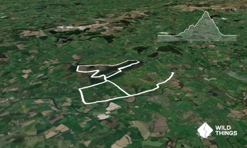
This is a scrambling one. Na Rathanan (the horns) are a dramatic landmark in the area and running over them requires some caution and respect, but if you're experienced and pick your day you're in for an absolute treat.
From the carpark head up the west (true left) side of the Abhainn Coire Mhic Nobuil, cross the bridge to follow the Allt a Bhealaich. Follow this until another bridge and the trail carries you away from the stream. When you come to a cairn take the left fork and prepare for the trail to get steep and technical.
The three horns can be bypassed to the left staying on the grassy slopes. I've never done this but I've heard that the grass is pretty steep and slippery, particularly after the first horn. Instead, pick your way over the horns themselves, there is generally a clear path to follow or obvious rock steps. If you don't like the look of the chimney descending the first horn, there are a series of nice traversing ledges to the left.
After na rathanan you can focus on enjoying the amazing views, particularly looking back at where you have come from. Sgùrr Mhòr is your highest point for this route, shortly after this you'll pass the dramatic Eag Dubh (the black cleft). Your second Munro summit for the route is Tom na Gruagaich, from there zig-zag down into Corie Nan Laogh, then the gradient eases and an excellent trail carries you back to the carpark.
This trail includes the peak Beinn Alligin-Sgurr Mor.
Waterfalls on Abhainn Coirie Mhic Nobuil, the horns themselves, the black cleft, views of the other Torridon mountains and over to Skye.
If you know of any public toilets near the trail start or on the route, please login and then let us know so we can update this section.
No public transport. Ample parking.
Yes
No
Moderate.
Weather changes extremely quickly on the West Coast. Always carry a map and compass and be ready to use them. Mostly there is a clear trail to follow.
Non-existent.
Thermal leggings, Long-sleeved thermal top, Seam-sealed waterproof jacket, Gloves, Beanie/thermal headwear, Whistle, First aid kit, Extra food for emergencies, Survival bag, Cellphone, Compass, Map, Crampons / microspikes (for winter conditions)
Fill up at the second bridge, no more water until you descend into Corie Nan Laogh.
Navigation and technicality greatly increases in winter, generally this is a summer route for running.
Steep rocky conditions. Cornices if tackling in winter conditions.
The Torridon General Store
Torridon village
Do you have another suggestion on where to go afterwards for the best coffee / cake / breakfast / brunch / beer?
Fastest Known Times (FKTs)
You and The Horns of Alligin
As a VIP member you can record private notes for this trail, see all of your times and more.
Already have an account? Login now
Send to your phone
Scan the below QR code to open this trail on your phone.

Tip: position the QR code in your phone camera screen.