Last Updated: 20th Aug 2024
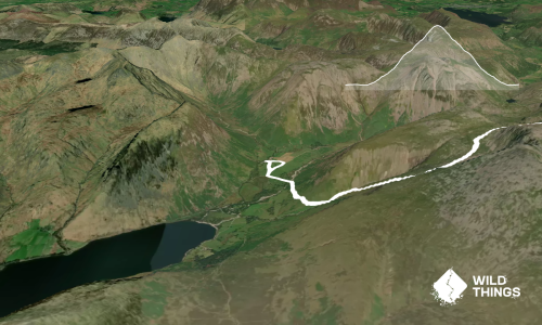
Creag Meagaidh munro loop
Last Updated: 20th Aug 2024
Open
Grunt Factor: 48 ?
Gnarl Factor: 56 ?
20.8km
1235m
1205m


Last Updated: 20th Aug 2024
Last Updated: 20th Aug 2024
Open
Grunt Factor: 48 ?
Gnarl Factor: 56 ?
20.8km
1235m
1205m
Back country - remote
Loop
Mountainous
Dog Friendly
Plantation/exotic forest
Lakeside
Open farmlands
Open tussock/grasslands
Open ridges/tops
Farm Road / 4WD Track
Easy Single Track
Moderate Single Track
Technical Single Track
Untracked / Route only
Average Uphill Gradient: +12.00%
Average Downhill Gradient: -11.70%
VIP Feature: Send this route to your Garmin account so you can follow the course on your Garmin device.
Become a VIP Member to see the trailhead information.
7:00
Slow
4:00
Moderate
2:30
Fast
We are eager to expand our Trail Running Directory in the UK and Ireland. For a limited time, if you submit any trail in the UK and Ireland and we publish it, we'll double the credit you receive! Submit a new trail now.
From the carpark, take the path up towards the Aberarder farm buildings (which includes the public toilets). Follow the signposted route to the right of the buildings and over a small bridge to the woods. After approximately 1.5km from the carpark, there is a small cairn and path which heads up right through the birch wood. Take this path and continue up the track to Carn Liath – this is the biggest climb of the day. The path continues northwest getting rockier as you ascend, then the angle eases off toward the summit. The rounded summit is marked by a cairn.
From the summit of Carn Liath, head west down the open slopes, over Meall an t-Snaim, and on to a short, steep ascent to Sròn Coire a'Chriochairein. Continue curving along the ridge to the summit of Stub Poite Coire Ardair (marked with a cairn).
From the summit, descend in a south to southwest direction to ‘the Window’, then turn southeast (still following the path) and start climbing up the zig zag path through the scree, which eventually levels out to a plateau. Continue along the plateau – note that the first cairn is not the summit (it is ‘Mad Megs Cairn’). To reach the summit, continue approximately 500m in a westerly direction.
From Creag Meagaidh, retrace your steps back to the ‘window’, then follow the bouldery path that zig zags down the hill to Lochan a’Choire and continue on the path back to the carpark.
This trail includes the peaks Creag Meagaidh, Stob Poite Coire Ardair and Carn Liath.
Three munros, a lochan with steep cliffs as a backdrop (these cliffs are reported to be some of the best ice climbing in Scotland in the winter), and Mad Megs cairn (apparently an 18th century burial mound).
Next to the Aberarder farmhouse (just after the start of the trail).
Parking available at the Creag Meagaidh National Nature Reserve car park. No public transport
Yes
No
Hard.
Monderate to navigate in good weather. Navigation is significantly more challenging in fog or snow. The summits are often in cloud, so careful navigation is required on the tops – especially between Carn Liath and Stob Poite Coire Adair.
Patchy.
Waterproof leggings, Thermal leggings, Lightweight fleece top, Long-sleeved thermal top, Seam-sealed waterproof jacket, Windproof jacket, Gloves, Beanie/thermal headwear, Personal Locator Beacon (PLB), Whistle, First aid kit, Extra food for emergencies, Survival bag, Cellphone, Compass, Map, Headtorch and spare batteries, Crampons / microspikes (for winter conditions)
Water is available coming down from 'the Window', little water available on the tops.
High winds are to be expected all year round on the tops and there is no shelter. Snow and ice hazards in winter.
It is a serious winter mountain route with steep, treacherous ground on the side of the mountains, and has a high avalanche risk (especially in ‘the Window’ area)
Potential steep drops, difficult to navigate in bad weather. Winter avalanche risk.
Do you have a suggestion on where to go afterwards for the best coffee / cake / breakfast / brunch / beer?
Fastest Known Times (FKTs)
You and Creag Meagaidh munro loop
As a VIP member you can record private notes for this trail, see all of your times and more.
Already have an account? Login now
Send to your phone
Scan the below QR code to open this trail on your phone.

Tip: position the QR code in your phone camera screen.
Plan smarter, stay motivated, track your progress, and unlock the full Wild Things experience — while saving along the way.