Last Updated: 2nd Aug 2024
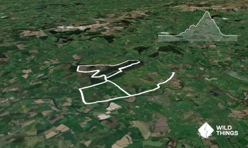
Lochnagar Loop
Last Updated: 2nd Aug 2024
Open
Grunt Factor: 37 ?
Gnarl Factor: 37 ?
19.1km
905m
905m


Last Updated: 2nd Aug 2024
Last Updated: 2nd Aug 2024
Open
Grunt Factor: 37 ?
Gnarl Factor: 37 ?
19.1km
905m
905m
Back country - remote
Loop
Mountainous
Dog Friendly
Lakeside
Open ridges/tops
Gravel Road
Farm Road / 4WD Track
Moderate Single Track
Technical Single Track
Average Uphill Gradient: +9.50%
Average Downhill Gradient: -9.50%
VIP Feature: Send this route to your Garmin account so you can follow the course on your Garmin device.
Become a VIP Member to see the trailhead information.
3:30
Slow
2:45
Moderate
2:00
Fast
We are eager to expand our Trail Running Directory in the UK and Ireland. For a limited time, if you submit any trail in the UK and Ireland and we publish it, we'll double the credit you receive! Submit a new trail now.
Starting from the Glen Muick car park, continue along the main path past the toilets and the wee visitor centre. Turn right at the sign for Lochnagar.
Continue along the path until you reach an abandoned house - take the small path to the left of the house and continue up into the woods. Soon you will exit the woods onto open terrain and a sandy path, veer left and continue to follow this track, there is a burn crossing, the water can be quite high at times, and you’re not guaranteed dry feet!! The path becomes more rocky as you gradually ascend, watch your footing!
You will eventually come to a cairn and a fork in the road, take the narrower path to the left, there is a small drop-down and then the real ascent begins!
Follow the path up to the col, where you will get a marvellous view of the Dubh Loch with Lochnagar looming above it. Take the less defined path to the left through the boulders and continue on upwards!
When you reach a flatter section, veer to the right and follow the small cairns that mark the way to the summit, you will come across a small section of steps and then a flatter section before reaching the summit cairn and trig. Take in the glorious views and then retrace your steps to the stairs section where you will see a rocky path veering off to the right.
You will descend on this path all the way down to a bridge where you turn left and follow alongside the burn to a waterfall and then down further to the Bothy at the lochside via a small wooded section. At this point the GPX takes you left at the bothy, round the north side of Loch Muick on an easy gravel track all the way back to the car park. However, if you still have life left in your legs and fancy a more technical trail and a marginally longer distance then turn right at the bothy and follow the Loch round to the south side, to find a small beach and another wee waterfall, continuing all the way back to the car park.
This trail includes the peak Lochnagar-Cac Carn Beag.
At the carpark/start of trail.
There is ample parking, however this can get busy during summer. Availability for camper vans to park overnight. There is a charge of £5 per car and £10 per campervan for 24hrs.
Yes
No
Hard.
Easy to navigate in good weather. However, navigation can become challenging in fog or snow, especially from the col onwards. There is a steep drop to the north/right when ascending the final section of the trail to the summit.
Generally good.
Waterproof leggings, Thermal leggings, Lightweight fleece top, Long-sleeved thermal top, Seam-sealed waterproof jacket, Windproof jacket, Gloves, Beanie/thermal headwear, Personal Locator Beacon (PLB), Whistle, First aid kit, Extra food for emergencies, Survival bag, Survival blanket, Cellphone, Compass, Map, Headtorch and spare batteries, Crampons / microspikes (for winter conditions)
Water readily available before turning off the 4WD track at the cairn, and available again from the bridge crossing on the descent.
Snow and ice hazard in winter. High winds are to be expected all year round. Weather changes can happen very quickly.
Potential steep drops, hard to see in bad weather.
The Bothy
Ballater
Tea room attached to a wee outdoor shop
Do you have another suggestion on where to go afterwards for the best coffee / cake / breakfast / brunch / beer?
Fastest Known Times (FKTs)
You and Lochnagar Loop
As a VIP member you can record private notes for this trail, see all of your times and more.
Already have an account? Login now
Send to your phone
Scan the below QR code to open this trail on your phone.

Tip: position the QR code in your phone camera screen.
Plan smarter, stay motivated, track your progress, and unlock the full Wild Things experience — while saving along the way.