Last Updated: 1st Aug 2024
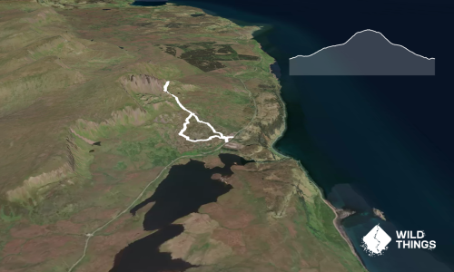
Loch Kinord and Burn O Vat
Last Updated: 1st Aug 2024
Grunt Factor: 11 ?
Gnarl Factor: 15 ?
9.7km
175m
175m


Last Updated: 1st Aug 2024
Last Updated: 1st Aug 2024
Grunt Factor: 11 ?
Gnarl Factor: 15 ?
9.7km
175m
175m
Front country - easily accessible
Loop
Undulating, small hills only
Dog Friendly
Lakeside
Easy Single Track
Moderate Single Track
Average Uphill Gradient: +3.50%
Average Downhill Gradient: -3.60%
VIP Feature: Send this route to your Garmin account so you can follow the course on your Garmin device.
Login as a VIP to see the trailhead information.
1:30
Slow
1:00
Moderate
0:45
Fast
We are eager to expand our Trail Running Directory in the UK and Ireland. For a limited time, if you submit any trail in the UK and Ireland and we publish it, we'll double the credit you receive! Submit a new trail now.
Starting at the carpark, take the track past the wooden holiday cabins and continue through the woods to the lochside, take a right once you reach the loch viewing platform and continue to the gates. Turn left at the gates to follow the lochside, you will pass some ruins of buildings on the south side of the loch and eventually come to a junction, either fork will take you to the same point, turn right to hug the loch and pass a small bothy, follow the GPX and continue straight on to follow the woods, or take the less obvious left turn to reach the boardwalk.
These paths all merge back onto the same path on and bring you to the roadside where you cross over to the Burn O Vat car park.
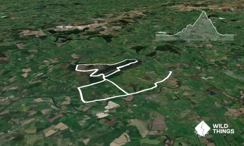
From the car park turn left and continue past the visitor centre and the toilets, follow the path over a couple of bridges and when you get to a fork in the path continue straight to climb through some rocks and find the hidden waterfall, watch your footing, it's wet and slippy!
Retrace your steps back to the fork, turn left and cross the bridge, continue straight to follow the path to the viewpoint over Loch Kinord, then descend back down to the carpark.
Cross the road again and pick up the path where you left it, turn left and follow the undulating path through the trees until you reach the lochside again.
You will come to a fork in the road, veer right and drop down to the lochside, and follow the path all the way back to the gates from the beginning of this run.
Head back via the initial path and viewing platform to the carpark.
Burn o vat waterfall.
At the burn o vat visitor centre.
Car park can become busy during the summer. There is also parking available just outside Dinnet and also at the Burn o Vat visitor centre that would take you on this trail via a different start point. There is also overnight campervan parking available for a small fee at the burn o vat visitor centre.
Yes
No
Easy.
If in doubt keep the loch to your right and just keep running!
Generally good.
Seam-sealed waterproof jacket, Whistle, First aid kit, Cellphone, Map
Water is available at the visitor centre.
Sections can become boggy and slippy in wet weather .
Ground nesting birds and adders at certain times of year.
Do you have a suggestion on where to go afterwards for the best coffee / cake / breakfast / brunch / beer?
Fastest Known Times (FKTs)
You and Loch Kinord and Burn O Vat
As a VIP member you can record private notes for this trail, see all of your times and more.
Already have an account? Login now
Send to your phone
Scan the below QR code to open this trail on your phone.

Tip: position the QR code in your phone camera screen.