Last Updated: 2nd Aug 2024
An Socach
Last Updated: 2nd Aug 2024
Grunt Factor: 36 ?
Gnarl Factor: 45 ?
17.2km
780m
780m


Last Updated: 2nd Aug 2024
Last Updated: 2nd Aug 2024
Grunt Factor: 36 ?
Gnarl Factor: 45 ?
17.2km
780m
780m
Back country - remote
Out and Back
Mountainous
Dog Friendly
Open farmlands
Open ridges/tops
Gravel Road
Farm Road / 4WD Track
Moderate Single Track
Technical Single Track
Average Uphill Gradient: +9.10%
Average Downhill Gradient: -9.00%
VIP Feature: Send this route to your Garmin account so you can follow the course on your Garmin device.
Login as a VIP to see the trailhead information.
1:45
Slow
2:15
Moderate
3:00
Fast
We are eager to expand our Trail Running Directory in the UK and Ireland. For a limited time, if you submit any trail in the UK and Ireland and we publish it, we'll double the credit you receive! Submit a new trail now.
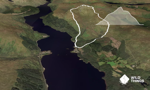
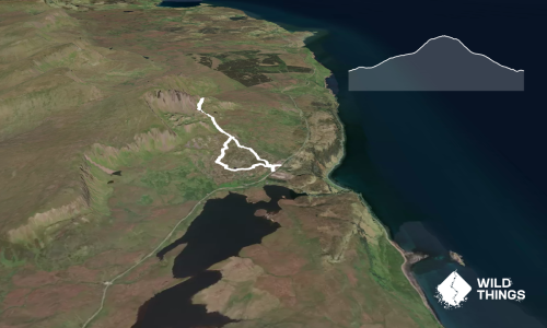
Cross the road from the lay-by and continue through the gate and past the farm buildings, follow the path round to your left and continue along the river until you reach a bridge with a well flowing burn. Top up your bottles here as there’s not much water from here on.
Cross the bridge and take the small track on the right up the side of the burn. Continue up this track, until it flattens off and veers to the left again and through a potentially boggy section to reach the first small summit with a cairn.
On a clear day look west and you will see where you are heading, drop down off the summit and then begin a second climb of the day, the path gets fainter and there are multiple options to take, these are easy to see on a clear day, but navigation could be tricky if the fog rolls in.
There is a second summit cairn that marks the east top of An Socach, however this is not the highest point and you need to continue along the hill to the west and over the boulders to reach the true top of An Socach and the stunning panorama views.
Take in the views and retrace your steps back to the starting point.
Braemar and Glenshee Ski Centre
Limited parking in a number of small lay-bys by the beginning of the track, these lay-bys can get busy on nice days, please do not block access or passing places when looking for a space.
Yes
No
Hard.
Sections of this route have multiple options, these are easily visible on a clear day, but considerably trickier to identify in foggy conditions.
Generally good.
Waterproof leggings, Thermal leggings, Lightweight fleece top, Long-sleeved thermal top, Seam-sealed waterproof jacket, Windproof jacket, Gloves, Beanie/thermal headwear, Personal Locator Beacon (PLB), Whistle, First aid kit, Extra food for emergencies, Survival bag, Survival blanket, Cellphone, Compass, Map, Headtorch and spare batteries, Crampons / microspikes (for winter conditions)
Water readily available for the first and last 2 miles of the trail, once the bridge is reached and the ascent begins there is no fresh water available.
Very exposed to wind at the top at any time of the year. Snow in the winter can be very deep and impassable.
Hazelnut Patisserie
Braemar
For a fancy piece when you’ve finished your run!
The Highlanders Bakehouse
Crathie
Delicious home made bread and home bakes, with the best service and lovely outdoor seating area
Do you have another suggestion on where to go afterwards for the best coffee / cake / breakfast / brunch / beer?
Fastest Known Times (FKTs)
You and An Socach
As a VIP member you can record private notes for this trail, see all of your times and more.
Already have an account? Login now
Send to your phone
Scan the below QR code to open this trail on your phone.

Tip: position the QR code in your phone camera screen.