Last Updated: 30th Sep 2025
Banteer-Mt Hillary loop
Last Updated: 30th Sep 2025
Open
Grunt Factor: 20 ?
Gnarl Factor: 8 ?
24.2km
475m
470m

Last Updated: 30th Sep 2025
Last Updated: 30th Sep 2025
Open
Grunt Factor: 20 ?
Gnarl Factor: 8 ?
24.2km
475m
470m
Front country - easily accessible
Loop
Undulating, small hills only
Dog Friendly
Native bush
Open farmlands
Open tussock/grasslands
Sealed Road
Farm Road / 4WD Track
Easy Single Track
Average Uphill Gradient: +3.90%
Average Downhill Gradient: -3.90%
VIP Feature: Send this route to your Garmin account so you can follow the course on your Garmin device.
Become a VIP Member to see the trailhead information.
3:00
Slow
2:15
Moderate
1:45
Fast
We are eager to expand our Trail Running Directory in the UK and Ireland. For a limited time, if you submit any trail in the UK and Ireland and we publish it, we'll double the credit you receive! Submit a new trail now.
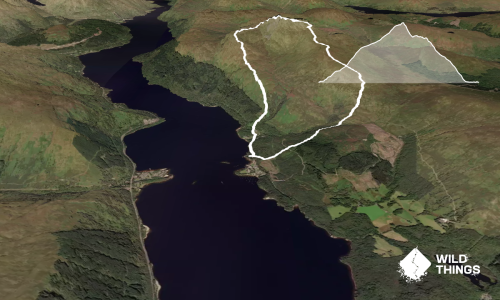
Starting in Banteer, carpark across from the church, head down Clonmeen Road for 6-ish kilometres until you reach a T junction with a sign turning right labelled Mt Hillary trail - follow this, crossing the train track for 2-3k and turn right at the intersection, again following the sign for the start of the trail - the trail beginning is heralded by a carpark on the left with a detailed map of the forest park - for a shorter run you can park here and do a 10.8km loop.
Entering the park, head up the trail for 100m or so until the trail splits - turn right, following the RED arrows - this is the longer loop.
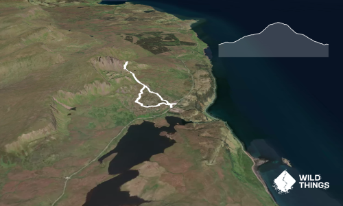
Gently wind your way up Mt Hillary, taking in the view and just be sure to keep following the red markers; it's difficult to get lost this way. This loops back to the carpark where you turn left for 50m or so over a little bridge and turn right down Curraghrour West, signs for Mt Hillary Holiday Pods - follow this back to Clonmeen Road, turning left back to the first road you came and into the centre of Banteer again
Fantastic view of the surrounding landscapes from peak of Mt Hillary.
None.
Free parking at Eagle View, also for the shorter loop carpark at the start of the trailhead can fit 8-10 cars.
Yes
No
Easy.
Heading up the long gentle slope towards Mt Hillary summit there is a 90degree right turn where the red trail continues, it's a little hidden by gorse, there's a handy information sign with a picture of a red squirrel on it for reference! Caution on the narrow Irish roads.
Generally good.
Lightweight fleece top, Long-sleeved thermal top, Windproof jacket, Gloves, Beanie/thermal headwear, Whistle, First aid kit, Extra food for emergencies, Cellphone, Map
Bring your own, no water on the route.
Caution in poor conditions, very windy on the summit and can get very boggy underfoot towards the top.
None really, just cars on the road.
The Vintage
Banteer
Cosy with hot food
White Country Inn
Banteer
Start of the run, standard pub
Do you have another suggestion on where to go afterwards for the best coffee / cake / breakfast / brunch / beer?
Fastest Known Times (FKTs)
You and Banteer-Mt Hillary loop
As a VIP member you can record private notes for this trail, see all of your times and more.
Already have an account? Login now
Send to your phone
Scan the below QR code to open this trail on your phone.

Tip: position the QR code in your phone camera screen.
Plan smarter, stay motivated, track your progress, and unlock the full Wild Things experience — while saving along the way.