Last Updated: 31st Jul 2024
Yule Calder Loop
Last Updated: 31st Jul 2024
Open
Grunt Factor: 16 ?
Gnarl Factor: 28 ?
12.9km
335m
335m

Last Updated: 31st Jul 2024
Last Updated: 31st Jul 2024
Open
Grunt Factor: 16 ?
Gnarl Factor: 28 ?
12.9km
335m
335m
Front country - easily accessible
Loop
Undulating, small hills only
Riverside
Open farmlands
Open tussock/grasslands
Open ridges/tops
Sealed Road
Farm Road / 4WD Track
Untracked / Route only
Average Uphill Gradient: +5.20%
Average Downhill Gradient: -5.20%
VIP Feature: Send this route to your Garmin account so you can follow the course on your Garmin device.
Login as a VIP to see the trailhead information.
2:30
Slow
1:50
Moderate
1:20
Fast
We are eager to expand our Trail Running Directory in the UK and Ireland. For a limited time, if you submit any trail in the UK and Ireland and we publish it, we'll double the credit you receive! Submit a new trail now.
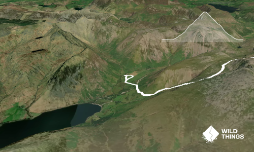
This is a great mixed loop with some off-track following your nose along a stream to connect track ends.
Start at the Oakenclough crossroads and head up the hill on the road. At the end of the plantation on your left head through a forestry gate and follow the track alongside the fence/wall gradually climbing up to Stang Yule.
At the first junction keep left, and again at the next two. The track will turn and start to head north. It then drops down to cross the Calder stream.
At this point the off-track section starts - follow the stream downstream, picking up rough sheep tracks and crossing wherever you need to. This is slow going with scrub and some boggy patches, but very pretty.
Eventually, you will come across a little bothy and barn, and the start of a 4WD track. Follow this out until it meets the road, turn left and head back along to the Oakenclough crossroad start point.
If you know of any public toilets near the trail start or on the route, please login and then let us know so we can update this section.
Unknown
No
Moderate.
Very patchy.
Long-sleeved thermal top, Seam-sealed waterproof jacket, Whistle, First aid kit, Extra food for emergencies, Cellphone, Map
Do you have a suggestion on where to go afterwards for the best coffee / cake / breakfast / brunch / beer?
Fastest Known Times (FKTs)
You and Yule Calder Loop
As a VIP member you can record private notes for this trail, see all of your times and more.
Already have an account? Login now
These overlap with this trail to some degree. You may wish to combine them but please note that to qualify for FKTs on these runs you should record a separate activity for each.
Send to your phone
Scan the below QR code to open this trail on your phone.

Tip: position the QR code in your phone camera screen.