Last Updated: 31st Jul 2024
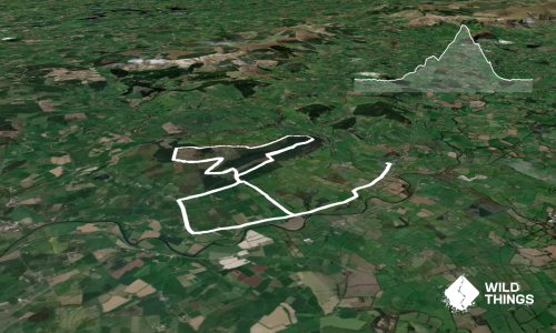
Stang Yule
Last Updated: 31st Jul 2024
Open
Grunt Factor: 16 ?
Gnarl Factor: 17 ?
13.7km
455m
460m

Last Updated: 31st Jul 2024
Last Updated: 31st Jul 2024
Open
Grunt Factor: 16 ?
Gnarl Factor: 17 ?
13.7km
455m
460m
Front country - easily accessible
Combo
Undulating, small hills only
Plantation/exotic forest
Open farmlands
Open ridges/tops
Sealed Road
Farm Road / 4WD Track
Moderate Single Track
Average Uphill Gradient: +6.60%
Average Downhill Gradient: -6.60%
VIP Feature: Send this route to your Garmin account so you can follow the course on your Garmin device.
Login as a VIP to see the trailhead information.
2:15
Slow
1:45
Moderate
1:20
Fast
We are eager to expand our Trail Running Directory in the UK and Ireland. For a limited time, if you submit any trail in the UK and Ireland and we publish it, we'll double the credit you receive! Submit a new trail now.
This description starts from the Oakenclough crossroads for a 1.5km gentle hill road warm-up - you can park up by the start of the loop and cut 3km off as needed.
When you get to the end of the plantation along the left side of the road follow the road to the left and then through a yard to a forestry gate, signed to Stang Yule.
Cross through here then follow the rough 4WD track that follows the wall/fence gradually uphill.
At the first junction just over the high point either bee-line through the fell (as per the map) or take the lefthand turn. As the track starts to descend and turn to the left/north you will see a single track path head straight on - follow your nose along here, with paving stones along part of it.
At the next junction (through a stile) take the right-hand track which heads diagonally downhill back across the hill you've come along the top of. This then turns straight downhill before reaching the farm road.
Head right here through Clough Woods and the estate, and right again at the next junction, which will bring you out at the forestry gate again.
Head back down the road to the start point.
If you know of any public toilets near the trail start or on the route, please login and then let us know so we can update this section.
Unknown
No
Moderate.
Patchy.
Long-sleeved thermal top, Seam-sealed waterproof jacket, Beanie/thermal headwear, Whistle, First aid kit, Extra food for emergencies, Cellphone, Map
Do you have a suggestion on where to go afterwards for the best coffee / cake / breakfast / brunch / beer?
Fastest Known Times (FKTs)
You and Stang Yule
As a VIP member you can record private notes for this trail, see all of your times and more.
Already have an account? Login now
These overlap with this trail to some degree. You may wish to combine them but please note that to qualify for FKTs on these runs you should record a separate activity for each.
Send to your phone
Scan the below QR code to open this trail on your phone.

Tip: position the QR code in your phone camera screen.