Last Updated: 17th Oct 2025
Scafell Pike Out and back
Last Updated: 17th Oct 2025
Open
Grunt Factor: 36 ?
Gnarl Factor: 71 ?
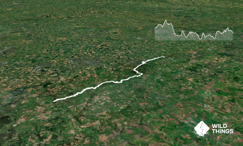
10.8km
940m
925m

Last Updated: 17th Oct 2025
Last Updated: 17th Oct 2025
Open
Grunt Factor: 36 ?
Gnarl Factor: 71 ?
10.8km
940m
925m
Back country - remote
Out and Back
Mountainous
Dog Friendly
Open ridges/tops
Moderate Single Track
Technical Single Track
Average Uphill Gradient: +17.40%
Average Downhill Gradient: -17.20%
VIP Feature: Send this route to your Garmin account so you can follow the course on your Garmin device.
Become a VIP Member to see the trailhead information.
3:30
Slow
3:00
Moderate
2:30
Fast
We are eager to expand our Trail Running Directory in the UK and Ireland. For a limited time, if you submit any trail in the UK and Ireland and we publish it, we'll double the credit you receive! Submit a new trail now.
Scafell Pike at 978m is England's highest peak. Thousands go up it each year, but it is a fairly solid vert day out.
Start with the trail from the Wasdale Inn past the charming old church- England's smallest still operative church. Do take a peek inside. Follow the paths across the fields and head up the obvious trail that begins ascending diagonally up the lower hill slope ahead. Here you will pick up the summit track proper and get straight into extensive stair work.
Eventually you will reach a fork in the track. Go left into what is known as the Hollow Stones route. Stairs and zigzags will slowly lead you the the Lingmell Col, where you hang a right and ascend the summit ridge all the way to the summit lookout. Once you've finished enjoying the summit vistas (hopefully its not foggy!) you will retrace your steps back down. There are other route options down but they involve either more peaks or scrambling down steeper country. Plenty of scope for other trail directories to capture those.
Oh, and do take a moment to enjoy the fact that you are dabbling on one small section of the famous Bob Graham Round.
This trail includes the peak Scafell Pike.
England's highest peak and war memorial Bob Graham round views England's deepest lake.
At the pub.
Car parking available at Wasdale.
Yes
No
Moderate.
Have given the navigation rating as moderate because of the risk of mist and poor visibility- it would be easy to wander off piste up high. But on a clear day, no trouble.
Patchy.
Waterproof leggings, Thermal leggings, Long-sleeved thermal top, Seam-sealed waterproof jacket, Windproof jacket, Gloves, Beanie/thermal headwear, Personal Locator Beacon (PLB), Whistle, First aid kit, Extra food for emergencies, Survival bag, Survival blanket, Cellphone, Compass, Map, Headtorch and spare batteries
BYO.
Obviously a tougher proposition in winter.
Risk of fog/ mist.
Very exposed to the elements.
Wasdale Inn
Great beer, coffee and food
Do you have another suggestion on where to go afterwards for the best coffee / cake / breakfast / brunch / beer?
Fastest Known Times (FKTs)
You and Scafell Pike Out and back
As a VIP member you can record private notes for this trail, see all of your times and more.
Already have an account? Login now
Send to your phone
Scan the below QR code to open this trail on your phone.

Tip: position the QR code in your phone camera screen.
Plan smarter, stay motivated, track your progress, and unlock the full Wild Things experience — while saving along the way.