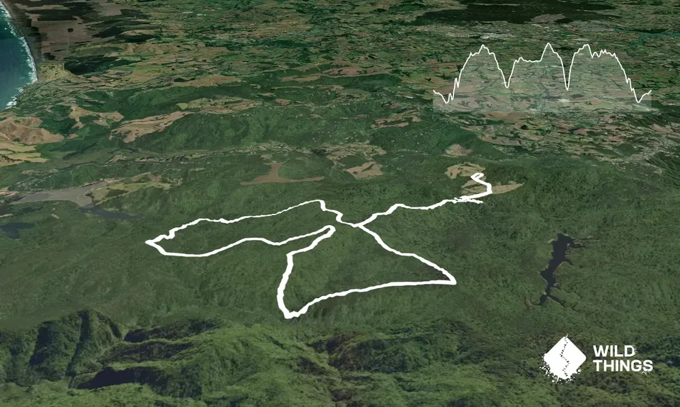
Assuming the gates locked you'll have to park the car near the golf club and run down the gravel road about 1km (if not locked drive in and knock 2km off the run). Once at the carpark at the end of the end of the road look for the trail sign and take the track down to the swingbridge 500m away (spraying your shoes at the dieback station of course on the way). Cross the bridge turn left and a few hundred metres up the track there's a right hand turn onto Upper Kauri Track (a maori carving stands there just up the track).
Climb up Upper Kauri track for 2-3km to a junction (Long Rd Tk) and turn right and follow the undulating Long Road track past the junction with Smyth Ridge Tk and onto the junction with Wainamu Bush Tk on your left (if you get to Lower Kauri Tk you've gone a little too far). Head down Wainamu Bush track for almost 2km where you'll cross Wainamu Stream and track a little along the stream in a cool valley till you see the track further along on the other side. From here the track meanders its way uphill to Wainamu Junction (you can take a short 1km or so diversion here to the Kuataika Trig which provides a great view over the Waitakere's to the coast - take Kuataika Track and look out for the short side track to the trig on your right if you want the view). Otherwise at the junction turn back onto Smyth Ridge Track and after a short downhill, climb your way up to the junction (on your right) with Sisam Tk. This ones a little technical rooty beauty that's hard yakka to get any pace on. Near the end this puppy drops steeply into Smyth Stream where you are at the top of a very narrow valley and waterfall (take care if you dare have a closer inspection because you are at the top of a long drop from here).
On the other side of the stream is Simla Track where you make up for all that steep down you just did in an equally steep up. Burn the legs by all means because its a short steep dig up and then more moderate gradient thereafter back to the top and a junction with Ridge Road track where you turn left.
Take this track to a junction at a small clearing (Simla) with FenceLine Tk and Long Road Tk. Take Long Road Tk (feels like an extension of the track you were just on) and follow this undulating track using the little side diversions marked Montana trail that avoid the steepest, slippery sections of Long Rd (they all are short side tracks that bring you quickly back to Long Road Tk.) Follow this to the junction with Upper Kauri Tk and retrace your footsteps back to the car.
Note : there are untold ways to lengthen this run so take a map and take you pick in terms of distance and terrain as its good country up here. My favourite extension is at Simla turn right down Fenceline Tk to Waitakere Dam and cross the Dam and just up the access road 100-200m you'll see a track on your left and stairs (Waitakere Tramline Walk). You can take this and then Anderson Tk to get back to the car also with a few extra km's.
Kauri Forest, Bush Streams, Cute Bunnies on the Golf Course
If you know of any public toilets near the trail start or on the route, please login and then let us know so we can update this section.
Plenty of car parking unless its the middle of the day in summer then expect crowds at this popular family picnic spot (you will leave the crowds behind on the first hill). No transport unless you take the train to Swanson and run out from there which is possible if you're desperate to run on some tarseal for a few kms.
Both streams usually have water in them that I have drunk out of (at your own risk). There's a water tap by the toilets at the road end but I am sure the DOC sign says boil it first (they always do right)
Can get muddy and wet in the Sisam/Simla Valley but only for short distance. Both streams (Simla and Wainamu) can run a bit higher in very heavy rain. I haven't found them unable to be crossed yet in the rain and on most days they're a trickle but take care in the rain, especially if it gets heavy.
I suggest an EPIRB as Simla and Sisam are not well used tracks and i couldn't imagine a stretcher in or out of the bottom of the valley they meet in. However, if you're not alone you are not too far (relatively speaking) from the Golf Club to go for help (assuming its daytime of course).
Swanson Station Cafe
Swanson
Built in the train station
The Hangar Bar
Central Park Drive Lincoln North http://www.thehangar.co.nz
Cold beers, good bar and restaurant with great pizza, burgers, stonegrill etc
Do you have another suggestion on where to go afterwards for the best coffee / cake / breakfast / brunch / beer?
These overlap with this trail to some degree. You may wish to combine them but please note that to qualify for FKTs on these runs you should record a separate activity for each.
We don't store or share your location; it's only used for these features. You can continue without it, just without distance sorting and live map features.
Send to your phone
Scan the below QR code to open this trail on your phone.
Tip: position the QR code in your phone camera screen.