New: LiDAR and Public Access overlays
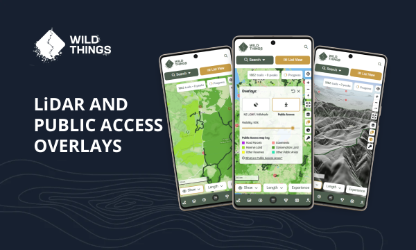
We've added new map overlays for VIP members: LiDAR and Public Access Areas, giving you more context to explore New Zealand terrain beyond trails and peaks.
24th July 2026
Share Update
We've added new map overlays for VIP members to help you better understand and explore New Zealand terrain: LiDAR and Public Access Areas.
Whether you're researching a new area, planning your own route, or simply curious about the landscape, these new overlays add another layer of context beyond trails and peaks.
LiDAR Overlay
LiDAR uses airborne laser surveys to create an incredibly detailed model of the landscape, revealing terrain features that often aren't visible on standard maps.
Whether you're trying to understand the shape of a ridgeline, spot old forestry roads, or get a better feel for the terrain ahead, the new LiDAR overlay can provide valuable extra context. You can also adjust the overlay transparency to blend it with your chosen map style.
Learn more about LiDAR and how to use it.
Public Access Areas
We've also added a Public Access overlay, showing recognised public access land from Herenga ā Nuku (the Outdoor Access Commission).
The Public Access overlay is a great way to better understand where recognised public access land exists. Just keep in mind it's only one piece of the picture — many trails and peaks in Wild Things are on forestry land, urban parks, private land with permission, or other areas that don't appear in the overlay. As always, check the trail or peak page for the latest access information and any permissions or restrictions.
As with LiDAR, the overlay transparency can be adjusted so you can compare it alongside your chosen map.
Learn more about Public Access areas.
VIPs, look for this overlay icon next time you're browsing the Trail Directory map:

As always, we'd love to hear what you think. If you have ideas for improvements or features you'd like to see next, just drop us an email at support@wildthings.club.
