Last Updated: 14th Feb 2024

Intermediate

Save Trail Save

I've done it Done

From Coal to Iron: Denniston to the Iron Bridge

Denniston Shortcut, Old Ghost Road Roundabout

Old Ghost Road Roundabout, Denniston Township Walk, Brakehead Track

Denniston, West Coast

Submitted by Stewie Stuart

Last Updated: 14th Feb 2024

Intermediate

Save Trail Save

I've done it Done

Open

Grunt Factor: 39 ?

Gnarl Factor: 7 ?

37.6km

1280m

1785m


Login as a VIP to see driving directions, distance and time.

Trail Map

Type of Run

Front country - easily accessible

Point to Point (one way)

Undulating, some big hills

Native bush

Riverside

Open ridges/tops

Run Makeup

5%
95%

Sealed Road

Farm Road / 4WD Track

Average Uphill Gradient: +5.8%

Average Downhill Gradient: -8.1%

Trailhead

Login as a VIP to see the trailhead information.

Estimated Times to Run

8:00

Slow

6:00

Moderate

4:00

Fast

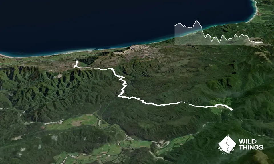
This run follows part of the Old Ghost Road Roundabout Cycle Route. By the route starting at the top of Denniston, it reduces the distance by 5.3km and cumulative vert by 556m.

From the Denniston Coalmining Parking area, follow the Denniston Carpark to Brakehead track towards the viewpoint for the Denniston Incline. On a clear day you will have a view of the Waimangaroa River where it reaches the Tasman Sea as well a view down the Historic Denniston Incline.

Retrace your steps back to the carpark area and begin to head inland along Boswell Street. After 500m turn right along a short 500m track called the Denniston Township Walk. This pops out at Whareatea Mine Road where a toilet is located. Turn left here, then right again to continue inland along Burnetts Face Road, which soon turns to gravel (rough in places) and becomes Cedar Creek Road.

Approximately 7km from the Denniston Visitor Centre and 200m after crossing a bridge (Cedar Creek), continue past the track on your right (grid ref 044 774) and keep heading north north/east. At or about grid ref 050 785, begin a 140m climb up onto the Mt William Range. Having crested the range and now travelling in a southerly direction, take a left turn and follow the main gravel road down to Stevenson Stream and then Mt William Stream.

At grid ref 086 738, turn left and climb, then drop to the Orikaka/Mackley River. Be warned: this is a big river, which can rise quickly following rainfall, and it is recommended that you take extreme care. Do not attempt to cross the river if it is fast flowing and brown. Even in dry conditions, the Orikaka/Mackley River requires wading through knee deep, albeit fairly slow-moving water. On the far side of the river, there is a very steep 1km-long climb (gaining 200m in elevation). At the top, miss the first two left turns and then a right turn. Drop down to the pylon where the wires fork.

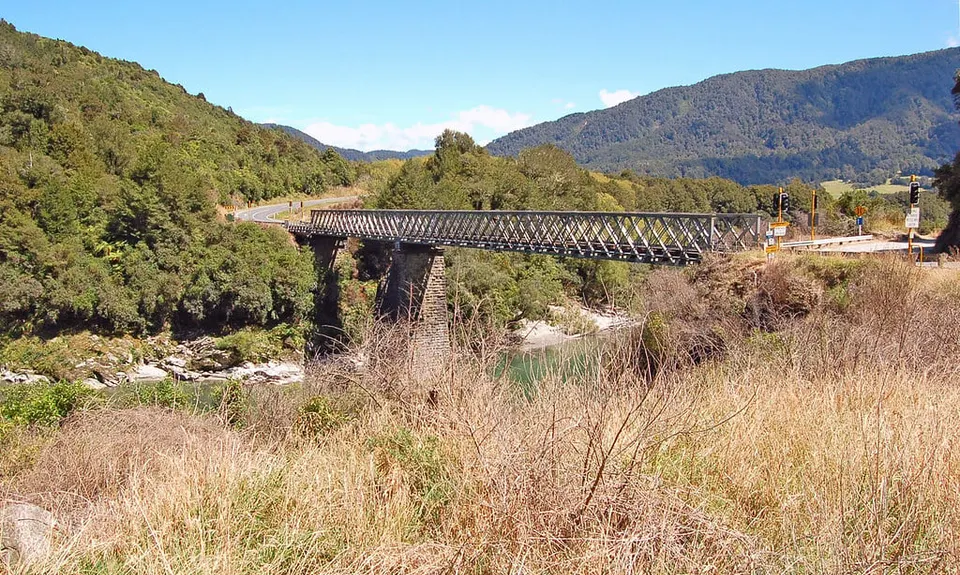
At the pylon, turn left to follow the main gravel road. Ride down the main road that follows the pylons. The route then hits Pensini Road, turn left and follow this for 1km around the large bend in the Buller River before it meets with New Creek Road. Turn right and follow New Creek Road south east towards the Iron Bridge.

Mine workings all throughout the area, Orikaka Ecological Area.

If you know of any public toilets near the trail start or on the route, please login and then let us know so we can update this section.

As this is a point-to-point track you will need to either have two cars or arrange for a pickup at the end point near the Iron Bridge on the Upper Buller Gorge Road. In Denniston, parking is available along Young Street at 'Denniston Coalmining Parking' which has a public toilet. At the iron bridge, there is a small turn off bay on the true right side of the Buller River. This is a more open and exposed carpark so leave your car here at your own risk. Alternatively, you can park your second car at Lyell Camp Site (3km Extra) however the road is narrow and winding with vehicles approaching quickly.

1 km

3 minutes

Unknown

No

Moderate.

Patchy.

Thermal leggings, Long-sleeved thermal top, Seam-sealed waterproof jacket, Gloves, Beanie/thermal headwear, Personal Locator Beacon (PLB), Whistle, First aid kit, Extra food for emergencies, Survival bag, Cellphone, Map, Headtorch and spare batteries

Water can be drawn from the river and streams along the route. While it is mostly suitable for drinking, it is recommended that water is filtered or treated before drinking due to historic mine workings in the area.

Can be very exposed and hot in summer and cold/windy in winter along the top of the Denniston Plateau.

Cyclists use the trail so be wary of their approach. Do not attempt to cross the Orikaka river if it is fast flowing and brown.

You and From Coal to Iron: Denniston to the Iron Bridge

As a VIP member you can record private notes for this trail, see all of your times and more.

Register Now

Already have an account? Login now

Trail Reviews

Be the first to submit a review for From Coal to Iron: Denniston to the Iron Bridge!

Login to submit a review

Trail Running Community

Find people who are interested in or have completed this trail run.

You must register or login to view this feature.

Register Now