Last Updated: 30th Sep 2025
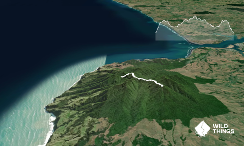
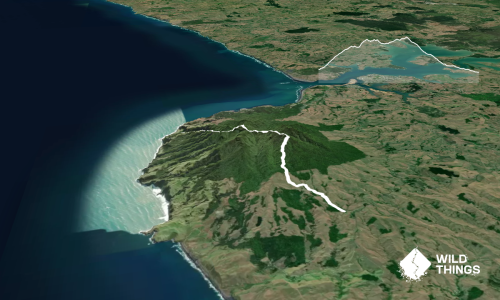
Kaitoke, Rangitahi and Te Hutewai
Raglan | Whāingaroa
Last Updated: 30th Sep 2025
Open
Grunt Factor: 12 ?
Gnarl Factor: 10 ?
15.1km
310m
310m


Last Updated: 30th Sep 2025
Last Updated: 30th Sep 2025
Open
Grunt Factor: 12 ?
Gnarl Factor: 10 ?
15.1km
310m
310m
Urban
Loop
Undulating, some big hills
Native bush
Beach
Coastal
Open farmlands
Sealed Road
Gravel Road
Easy Single Track
Average Uphill Gradient: +4.10%
Average Downhill Gradient: -4.10%
VIP Feature: Send this route to your Garmin account so you can follow the course on your Garmin device.
Become a VIP Member to see the trailhead information.
2:15
Slow
1:40
Moderate
1:00
Fast
Discover Raglan’s trails — stay at the heart of it all.
The Harbour View Hotel sits just minutes from the Kaitoke, Rangitahi and Te Hutewai tracks, offering warm hospitality, great food, cold drinks and a perfect post-run unwind.
With Raglan’s wild coastline, stunning bush walks and laid-back village vibe on your doorstep, it’s the ideal base for trail runners exploring Aotearoa’s natural playground.
Join the Kaitoke Walkway at the bottom of Roberston Street, and follow this 2.5km to it's end by the one-way bridge. Cross the bridge and continue along the footpath to Opotoru Rd on the left. Follow this road up, over the bridge into Rangitahi then when you hit Mara Kai Ln (on the left), cross over and join the off road trail (on the right).
Follow this grassy path all the way around the estuary and along the back of the golf course until you come to a farm gate. Go through the gate, and through the paddock to another gate at the top.
You'll come out on Te Hutewai Rd, head left up this road until you get to the Gravel Road sign (or carry on as far as you want for more undulating gravel).. admire the view from the top, and then head back down the road the way you came.
To make it a loop go down Te Hutewai Rd, all the way to its end, then turn right and follow Wainui Rd back to the bridge and then back onto the Kaitoke Walkway heading back to the start. Alternatively, you can go back through the paddock, make it an out and back, skipping Te Hutewai Rd, but it's a nice road really :-)
Easy trails through bush and fields with views of the estuary & Raglan coastline.
Public Toilets in town nearby, just along from the jetty on Cliff Street and next to the Information Centre on Wainui Rd.
There's a turnaround at the bottom of the road, where the Kaitoke Walkway (and this trail) starts, just park along there. The 23 Raglan bus service will get you pretty close to the start as well.
1 km
2 minutes
No
No
Easy.
Generally good.
Seam-sealed waterproof jacket, Cellphone
None on route.
Likely a small amount of mud if it has been wet.
The paddock has been known to have bulls in it.
Harbour View Hotel
14 Bow St, Raglan
https://www.harbourviewhotel.co.nz/restaurant-and-bar/
Good place for a beer or fish and chips, particularly evening time when everthing else in town closes.
Indi
5 Bow St, Raglan
https://www.facebook.com/IndiOnBow/
Great coffee and amazing cookies in a chill garden setting.
Do you have another suggestion on where to go afterwards for the best coffee / cake / breakfast / brunch / beer?
Trail Legend
Login as a VIP to become a Trail Legend. Learn about Trail Legends.
Fastest Known Times (FKTs)
You and Kaitoke, Rangitahi and Te Hutewai
As a VIP member you can record private notes for this trail, see all of your times and more.
Already have an account? Login now
Send to your phone
Scan the below QR code to open this trail on your phone.

Tip: position the QR code in your phone camera screen.