Last Updated: 23rd Feb 2026
The Punter
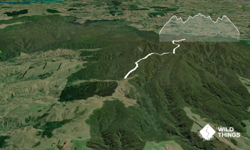
Link track - Ruapane
Link Track
Last Updated: 23rd Feb 2026
Closed More info
Grunt Factor: 19 ?
Gnarl Factor: 59 ?
8.5km
605m
605m


Last Updated: 23rd Feb 2026
Link Track
Last Updated: 23rd Feb 2026
Closed More info
Grunt Factor: 19 ?
Gnarl Factor: 59 ?
8.5km
605m
605m
Front country - easily accessible
Out and Back
Mountainous
Native bush
Easy Single Track
Moderate Single Track
Technical Single Track
Average Uphill Gradient: +14.30%
Average Downhill Gradient: -14.30%
VIP Feature: Send this route to your Garmin account so you can follow the course on your Garmin device.
Become a VIP Member to see the trailhead information.
2:30
Slow
1:20
Moderate
0:50
Fast
Follow track from the shelter and don't take any turns until you get past the bridge over the stream.
The warmup: Easy gravel descent from the start area.
The real warm up: Nice technical bit leading to stairs, and more tough climbing.
The run: gradient eases briefly after this first technical stretch, opening into perfectly runnable forest trail. The surface is firm and forgiving, winding through native bush with excellent flow and visibility. This is where runners can regain pace and composure before the next climb.
As the trail continues, it gradually steepens again, demanding a steady effort rather than bursts of speed. The route eventually connects with the end of the “Leg Burner” track, where the terrain shifts dramatically. The climb becomes rocky and uneven, requiring short, deliberate strides and good footing as it ascends toward the trig point — the course’s high mark.
The Highlight: turn around and come back the way you came as fast as you can. The middle section is where you can bring your overall pace right down.
This trail includes the peak Ruapane.
Long drop near the lodge.
Windy drive, massive carpark.
10 km
11 minutes
No
No
Easy.
Follow the markers and the beaten track.
Generally good.
Cellphone
None, unless you stop at the stream.
Do you have a suggestion on where to go afterwards for the best coffee / cake / breakfast / brunch / beer?
Trail Legend
Login as a VIP to become a Trail Legend. Learn about Trail Legends.
Fastest Known Times (FKTs)
You and The Punter
As a VIP member you can record private notes for this trail, see all of your times and more.
Already have an account? Login now
Send to your phone
Scan the below QR code to open this trail on your phone.

Tip: position the QR code in your phone camera screen.
Plan smarter, stay motivated, track your progress, and unlock the full Wild Things experience — while saving along the way.