Last Updated: 21st Sep 2023

Beginner - Intermediate

Save Trail Save

I've done it Done

Tapotupotu Bay to Cape Reinga

Kaitaia, Northland

Submitted by Anne-Louise Robertson

Last Updated: 21st Sep 2023

Beginner - Intermediate

Save Trail Save

I've done it Done

Open

Grunt Factor: 18 ?

Gnarl Factor: 34 ?

10.0km

630m

630m

244m


Login as a VIP to see driving directions, distance and time.

Trail Map

Type of Run

Front country - easily accessible

Out and Back

Very hilly

Native bush

Beach

Coastal

Run Makeup

70%
20%
10%

Easy Single Track

Moderate Single Track

Technical Single Track

Average Uphill Gradient: +13.5%

Average Downhill Gradient: -13.5%

Trailhead

Login as a VIP to see the trailhead information.

Estimated Times to Run

2:30

Slow

1.45:00

Moderate

1.15

Fast

This provides a shorter, logistically simpler, alternative to a full Cape Reinga to Spirits Bay run.

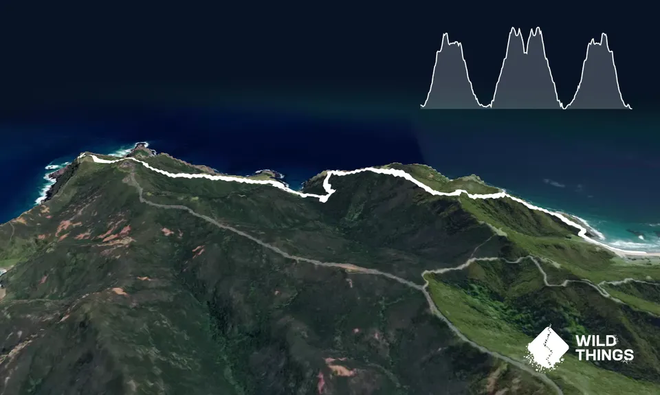
The track starts at the left hand corner of the beach up a clearly visible track. It climbs steadily, then steeply for 1km before descending for 2km to the Sandy Bay. The trail is really runnable after the first ascent. There are a couple of diversions to viewpoints if you fancy (not necessary if you are chasing a FKT!)

The trail goes through manuka trees as the trail snakes along the ridge then steps wind down more steeply to Sandy Bay. At Sandy Bay, the signage is a bit lacking but at the edge of the beach head straight across to where the headland juts out and the path goes up through the vegetation a few metres back. You will need to search a bit! The track climbs quite steeply and at first it's quite rocky and loose but that soon gives way to a runnable grassy slope and then gravelly trail.

The track emerges onto the Cape Reinga tourist track with 400m of free running on tarmac to the lighthouse. Dodge the tourists, enjoy the views, take a selfie and then head back and take the time to have a swim at Sandy Bay on the way!

Coastal flora and fauna.

Plenty of parking for visitors. Shuttle buses also run between the DoC Campsites and Cape Reinga.

110 km

94 minutes

Unknown

No

Moderate.

Sandy Bay

Generally good.

Short-sleeved thermal top, Windproof jacket, Gloves, Beanie/thermal headwear, Whistle, First aid kit, Extra food for emergencies, Survival blanket, Cellphone, Map, Headtorch and spare batteries

No streams or other water sources on the route.

Track is exposed on the ridges - would be interesting in wind and rain. Check tide times.

You and Tapotupotu Bay to Cape Reinga

As a VIP member you can record private notes for this trail, see all of your times and more.

Register Now

Already have an account? Login now

Trail Reviews

Be the first to submit a review for Tapotupotu Bay to Cape Reinga !

Login to submit a review

Trail Running Community

Find people who are interested in or have completed this trail run.

You must register or login to view this feature.

Register Now

Overlapping Trails

These overlap with this trail to some degree. You may wish to combine them but please note that to qualify for FKTs on these runs you should record a separate activity for each.

Cape Reinga to Spirits Bay

Cape Reinga to Spirits Bay

Length: 24.5km

Level: Beginner - Intermediate

Other trails nearby
Sweetwater Lakes

Sweetwater Lakes

Length: 19.0km

Level: Beginner - Intermediate

Find more trails and peaks nearby