Maunganui Bluff MayhemIntermediate
Submitted by Paul Barnes
Front country - easily accessible
Out and Back
Very hilly
Native bushOpen farmlandsOpen tussock/grasslandsOpen ridges/tops
Intermediate
4:30 (Slow)
3:30 (Moderate)
2:30 (Fast)
-16.8%
+16.7%
Fastest Known Times (FKTs)
Please set your gender to see your position on the FKT leaderboards.
Men
Women
There are currently no female FKTs for Maunganui Bluff Mayhem.
Filter FKTs
The more , the harder the FKT will be to beat. Learn about Fastest Known Times.
Description
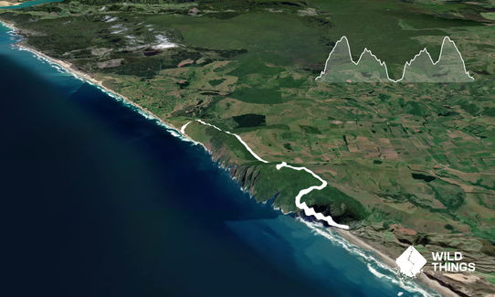
Take the Bluff Track from the car park which climbs gently at first, sidling around bluffs for a kilometre to a stream, then turning very steep for a few hundred metres with some stepped sections, leading into the forest. After 2km follow the track upwards next to farmland until reaching the aerial and follow the old 4WD access road to Bluff summit and stop to admire the views.
Take the track to Waikara Beach near the summit (signposted), leading downwards, very technical and steep in places. From the low point next to farmland continue following the track markers up the next hill for a kilometre until entering the forest again. If the grass is long then it can be ankle-twistingly uneven ground. The track continues gradually downwards on the open ridge tops until dropping very steeply to farmland where you can follow the cattle trails to the beach. Return the same way. Much of the last few km is barely tracked so follow the markers!
Trail Community
Features of interest
Old WW2 radar station at summit, gobsmacking views up and down the coast including Hokianga Harbour, Kai Iwi Lakes & Pouto Point on a clear day; native flora and fauna, wild pigs.
Make Up of Run
Untracked / Route only: 45%
Technical Single Track: 30%
Moderate Single Track: 20%
Farm Road / 4WD Track: 5%
Gravel Road: 0%
Sealed Road: 0%
Route Data
Reviews:
Photos:
Your Trail Wishlist
All the runs that are on your To Do list (no limit).
Add to wishlist view wishlistWild Explorers
I did it!-
Access
Take the Aranga Coast Road off SH12 and drive to Aranga Beach village a few minutes down the road.
Park next to the DOC sign on the right near the end of the village. Parking is fairly safe as is visible from road and houses.
43 km
39 minutes
No
No
-
Staying Safe
Moderate.
Difficult to go wrong as long as you watch for the signs and follow the markers.
Patchy.
Lightweight fleece top, Long-sleeved thermal top, Seam-sealed waterproof jacket, Beanie/thermal headwear, Whistle, First aid kit, Extra food for emergencies, Survival blanket, Cellphone, Map.
No drinkable water on route.
Some swampy parts in winter or after rain. Be careful on open ridge tops in strong winds.
Uneven ground, steep dropoffs.
-
Post run indulgence
Kaihu Pub
Kaihu
Only pub around. -
Sponsor this trail