Last Updated: 5th Apr 2024

Intermediate - Experienced

Save Trail Save

I've done it Done

Race Tekapo 32K Trail Run

Race Tekapo

Lake Tekapo, Canterbury

Submitted by Kerry Uren

Last Updated: 5th Apr 2024

Intermediate - Experienced

Save Trail Save

I've done it Done

Grunt Factor: 30 ?

Gnarl Factor: 20 ?

31.9km

475m

475m


Login as a VIP to see driving directions, distance and time.

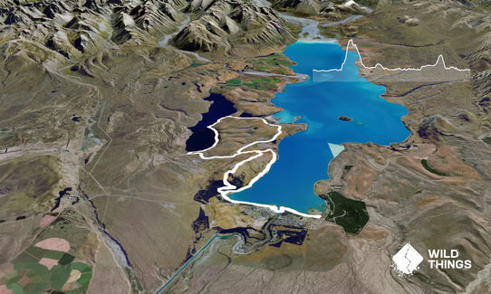
Trail Map

Type of Run

Front country - easily accessible

Combo

Undulating, some big hills

Lakeside

Open farmlands

Open tussock/grasslands

Open ridges/tops

Run Makeup

10%
10%
10%
30%
40%

Sealed Road

Gravel Road

Farm Road / 4WD Track

Easy Single Track

Moderate Single Track

Average Uphill Gradient: +3.0%

Average Downhill Gradient: -3.0%

Trailhead

Login as a VIP to see the trailhead information.

Estimated Times to Run

Not suitable

Slow

4:30

Moderate

2:30

Fast

The 32K Trail Run starts on the Village Green in Lake Tekapo - the grass area between the shops and the lake. You will take a short out-and-back section over the footbridge and past the Church of The Good Shepherd (stay on the paths on the lake side of the church).

Once you continue along the paths towards the Regional Park (forest) you will get to a junction near a carpark. At this point you will turn back and go back the way you came. Once you are back at the Village Green you will continue along the path network all the way to Tekapo Springs. The paths are on the lake side of the road as you head towards the springs.

Once you get to the entrance of the Tekapo Springs car park you will cross the road (carefully - watch for vehicles). There is a sign directing your way up the hill to the Mt John trail. Take this gravel road up past the pools and head into the forest. Continue the ascent of Mt John all the way through the trees - eventually you will pop out into the open tussocks/farmland.

You will head up towards the summit. It is steep and there will be a lot of walking! As you near the summit you will come across a sign - take the path to the right and head up to the rocky outcrop at the summit of Mt John. Take in the incredible views here - it's worth a photo (or two!).

You will then head along the path that runs below the observatory and cafe, continuing all the way along the top of Mt John. Enjoy view across Lake Tekapo as well as Lake Alexandrina (to the left). You will head over a fence (stile) and continue down the farmland.

Eventually you get to a point near the Hitching Post - the Hitching Post will be on your right but you will actually turn left here and make your way along the farm 4wd track to the sealed Mt John Access Rd. Turn right when you get to the seal and head down to the toll booth. Watch for traffic. At the toll booth turn right and run along Godley Peaks Rd for about 2km. Watch for traffic - especially holiday-makers/tourists.

You will come across the Peninsula Walkway entrance on your right. Take this walkway around the farmland - more great views! The course then heads through a fence and across the dry lake-bed towards Lake McGregor. Carefully cross the road and head along the access road to Lake McGregor and the Lake Alexandrina outlet.

Once you reach Lake Alexandrina you take the trail beside the lake for around 5km until you reach the huts at the end of the lake. Turn up the sealed road here and head back towards Mt John. You will reach Godley Peaks Rd where you will run down for around 100m - cross carefully here and head back up Mt John until you reach the 4wd track you came from.

Turn left onto Mt John until you reach the Hitching Post. At this point you will follow the trails all the way down the mountain, and the paths all the way back to the Village Green in Lake Tekapo.
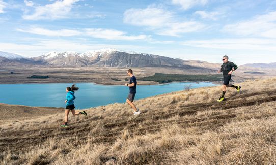
This trail includes the peak Mount John.

Incredible views of Lake Tekapo, Lake Alexandrina, and Lake McGregor. You also get to run alongside the Church of The Good Shepherd.

If you know of any public toilets near the trail start or on the route, please login and then let us know so we can update this section.

You can park in the parking areas in Lake Tekapo - plenty of parking near the shops.

1 minutes

No

Yes
Name: Race Tekapo
Telephone: n/a

Moderate.

This course is only accessible during the event - there are parts of the course that need directional signage, as well as being on private land only open during the event.

Very patchy.

Long-sleeved thermal top, Seam-sealed waterproof jacket, Whistle, First aid kit, Extra food for emergencies, Survival bag, Cellphone, Map

No access to water on this route outside of the race.

Alpine village - Lake Tekapo is just over 700m above sea level. Dress appropriately.

Rabbit holes - take care!
Traffic - roads are open.

You and Race Tekapo 32K Trail Run

As a VIP member you can record private notes for this trail, see all of your times and more.

Register Now

Already have an account? Login now

Trail Reviews

Be the first to submit a review for Race Tekapo 32K Trail Run!

Login to submit a review

Trail Running Community

Find people who are interested in or have completed this trail run.

You must register or login to view this feature.

Register Now

Overlapping Trails

These overlap with this trail to some degree. You may wish to combine them but please note that to qualify for FKTs on these runs you should record a separate activity for each.

Mt John - Lake Tekapo Loop

Mt John - Lake Tekapo Loop

Length: 8.2km

Level: Beginner

Race Tekapo 21K Half Marathon

Race Tekapo 21K Half Marathon

Length: 20.9km

Level: Beginner - Intermediate

Race Tekapo 50K Ultra

Race Tekapo 50K Ultra

Length: 49.4km

Level: Experienced

Other trails nearby
Race Tekapo 5K Run/Walk

Race Tekapo 5K Run/Walk

Length: 5.1km

Level: Beginner

Race Tekapo 12k

Race Tekapo 12k

Length: 11.8km

Level: Beginner - Intermediate

Race Tekapo 16K Trail Run/Walk

Race Tekapo 16K Trail Run/Walk

Length: 16.0km

Level: Beginner - Intermediate

Find more trails and peaks nearby