Last Updated: 2nd Aug 2024
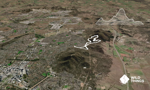
Loop the Mountains
Hackett, Canberra, Australian Capital Territory
Submitted by Emily Oliver
Last Updated: 2nd Aug 2024
Open
Grunt Factor: 22 ?
Gnarl Factor: 22 ?
19.8km
540m
535m


Last Updated: 2nd Aug 2024
Hackett, Canberra, Australian Capital Territory
Submitted by Emily Oliver
Last Updated: 2nd Aug 2024
Open
Grunt Factor: 22 ?
Gnarl Factor: 22 ?
19.8km
540m
535m
Urban fringe
Loop
Undulating, some big hills
Native bush
Farm Road / 4WD Track
Easy Single Track
Moderate Single Track
Technical Single Track
Average Uphill Gradient: +5.4%
Average Downhill Gradient: -5.4%
VIP Feature: Send this route to your Garmin account so you can follow the course on your Garmin device.
Login as a VIP to see the trailhead information.
4:30
Slow
2:30
Moderate
2:00
Fast
We are eager to expand our Trail Running Directory in Australia. For a limited time, if you submit any trail in Australia and we publish it, we'll double the credit you receive! Submit a new trail now.
From the Phillip Ave parking area, pick up the Ainslie Houses Track. Hang a left onto Ainslie Link Trail, then Socks Trail as it curves around the edge of the reserve. Just after 3 km, turn left onto Campbell Link Track and stick on this all the way until you meet the Telecom Trail, which is a wide and very runnable dirt road.
When you meet another road at about 7.5 km, turn uphill and follow the fenceline and footsteps of others until you hit another more defined trail at the top - turn right here and you're on Cherryburn Trail, which takes you downhill until you meet Blue Metal Rd at the top of the mountain bike park. Head down the road (the downhill MTB trails here are too dangerous to run down), then traverse along on Monterey Rd. Turn left off Monterey Road onto Betty Blue, then Mr Squiggle (these are also MTB trails, but are safer to run on. Still keep your ears out and give way to bikers, and stay on the road if you're not sure).
The end of these trails is a junction with a dirt road - cross it and pick up the walking trail, continuing uphill until you meet Mt Majura Road, which is sealed. Turn left and take this uphill for about 1.3 km until you reach the summit of Mt Majura. Pick up the trail that will take you down the opposite side, blast downhill for just under 1 km and then take a sharp right (at approx 15.5 km) - be careful not to miss this turn, as the trail continues straight ahead. The right-turn traverses you nicely around the contours - at 16km take the right at the fork, not the left/sharply down option - heading generally downhill until you reach Canberra Centenary Trail at the base of the hill.
Turn left and follow this main trail until you meet Hancocks Road - a right onto this will get you back to the start.
If you know of any public toilets near the trail start or on the route, please login and then let us know so we can update this section.
There is a parking lot at the end of Phillip Ave.
1 km
2 minutes
Unknown
No
Fastest Known Times (FKTs)
You and Loop the Mountains
As a VIP member you can record private notes for this trail, see all of your times and more.
Already have an account? Login now
These overlap with this trail to some degree. You may wish to combine them but please note that to qualify for FKTs on these runs you should record a separate activity for each.
Send to your phone
Scan the below QR code to open this trail on your phone.

Tip: position the QR code in your phone camera screen.