Tarn SK - Making History!

Eleanor Arnst
September 20, 2023 ShareIt’s always a bit of a weather risk when you schedule things weeks in advance, but with Katie (Wright) having relocated to Wanaka we took the plunge and pre-booked in a window of 12 - 14 March for a Tarn SK attempt. The forecast was stable and showed a fine couple of days between two fronts, and with Saturday being the slightly better of the two, we decided that would be the day and set about organising the final logistics of accommodation and transport.
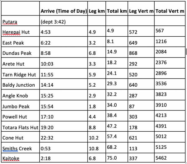
 At 03:41 we depart an already full Putara car park and head into the dark; me with a lot less nervous anticipation than when we started the Valleys SK in September. We’ve both covered much of the route before and know we can cover the distance, the only real question is “how long will it take?” It would be pretty awesome if we could go sub-24 hours. I’ve worked out the splits for 23:30 and hope I’m right, because neither of us really fancy the prospect of a sprint finish from the Puffer to scrape under 24 hours with seconds to spare.
Up the first hill to Herepai, and the rows of boots lined up outside indicate a full hut. It’s just before 5am, so we quietly fill our soft flasks, pull on waterproof pants and head on up the hill. The route is a bit overgrown through this next section and the vegetation can get quite wet; I don’t fancy getting out onto the tops soaked from the waist down. The higher we go, the windier it gets - a cold SE, but the forecast said it’s meant to ease off as the day goes on. It’s a bit of a dark trudge up the hill, both of us eye the eastern horizon periodically, waiting for the first glimpses of daylight.
In front of me, Katie reaches a waratah. “We need to go that way”, I call out and point right, recognising that we are on East Peak. We find the ground trail and head down into the saddle between East and West Peaks - a seemingly pointless 200m descent and reascent. We find ourselves too far to the right, check the GPS, shine the torches around, back track, and regain the correct trajectory. It’s still dark and now it’s claggy as well - making the headtorch lights reflect back at us. Wading through the last of the leatherwood, we start the climb up onto West Peak. The brief reprieve from the wind is gone, the cold gusts blowing us as we reach the top. “This is shit,” I think. I hate being cold. I want to go home. “Can you check the weather again?” I ask Katie as we try to shelter out of the worst of it. It still says the same - winds dropping after 10am. It’s just ticked over 7am and the sky is lighter, albeit no sun due to the low cloud. “Do you want to go back?” asks Katie, not sounding like she wants to. “Nah it’s ok, let’s just keep moving and stay warm,” I reply. Three hours until the wind drops - I can suffer that out. We have enough warm gear and my mind runs through the exit possibilities. If it’s still bad by the time we get to Arete we could bail out to Poads Road, or even drop down to Dundas Hut before then (but there’s no fire).
I have to be careful on the narrow rocky bits near Pukemoremore - time it between the gustier bits of wind so I don’t get blown off mid-stride. Another down, another up and we’re on Mt Dundas. I recognise this bit too and change direction slightly, making sure we head down the correct ridge. I’m pretty good at remembering bits of track and committing mental copies of maps to my memory. Pays off in the clag.
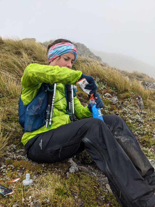
Suddenly the dark green of Arete Hut emerges from the fog. It’s 10:03. Good news is we’re only two minutes behind our scheduled 6 hours 20 minutes. The wind still blows. We duck inside for a quick snack and I put on an extra top layer. I’m now wearing a t-shirt, arm warmers, a thermal top, a windproof jacket, a rain jacket, gloves, buff, and gore tex overpants. I’m thankful for good gear. The new NIWA forecast predicted -1 at Arete Hut, I reckon that was a pretty accurate prediction. We head out, no discussion of bailing. Should be less than two hours to Tarn Ridge Hut, and the weather will be better by then, right? I’m just really grateful it isn’t raining.
 At the top of Pinnacle Spur we pause for the first photo of the day, before heading off into unknown territory; neither of us have been along this section of Tarn Ridge. The Waiohine Pinnacles are fun and straight forward, the rock mostly nice and solid underfoot - completely different to the Ruahines! We traverse carefully though, what with the wind and the clag there would be no quick rescue should either of us fall. Down onto the flatter section of the ridge we can start picking up the pace again, jogging past tarns as we repeatedly check our nav. We pause for a more substantial refuel at the bottom of the little dip before Tarn Ridge Hut. Battling the wind and the extra concentration required to make sure we stay on route results in us both being a bit down on nutrition. I know I’m definitely on the back foot and usually a lover of hills, I comment to Katie, “I think I forgot to pack my uphill legs”.
Moving on again, it isn’t long until Tarn Hut comes into view. The windows are open and we make the decision not to drop down to the hut as we don’t need any water, plus we’ve also made good time on this section and are now ahead of schedule. We whoop as we go past in case anyone is residence (but I don’t think there is). At 12:00 the weather still isn’t matching the forecast. I wonder how trying to keep warm and pushing into a head wind for hours will impact the second section of our run. Will it be a Valleys death march?
I struggle with the climb up to Girdlestone, where we are treated to about three minutes of sunshine. I feel a bit nauseous, but shove down another gel and sip at the Tailwind. I’m pretty much over it and ready to go home - I think that once we get to Powell I’ll head out to Holdsworth and Katie can go to Kaitoke on her own. I can’t face the thought of another nine hours down the valleys. I keep these thoughts to myself though - we can barely hear each other talk over the wind anyway. Pausing, I do tell Katie that today is a day of training mental resilience. She reassures me I’ll feel better in a couple of hours if I just keep getting the calories in. I force feed myself some more.
 On the south side of Girdlestone the raincoat finally comes off. It must be warming up a bit, although I’m still wearing three layers! The wind continues to blow, the clouds scud around us, the forecast is still wrong! This is obviously NOT one of the 80 clear days in the Tararuas! We carry less water through this section, but fill up regularly at the tarns. We cross Adkin, barely even registering it and wiggle our way along the ridge to the Kings. Human shapes emerge from the cloud and it’s two trampers who ask us to confirm their location, which we agree later is mildly concerning. These are not good conditions to be unsure of where you are!
We’ve had very little conversation so far. The wind just blows away any words, and most of our focus is needed to go into staying warm, safe, and on the right route, but we make a quick plan for refuelling again near Mid King. We shelter on the western side of the ridge, I prep my bottles with Rebuild and Tailwind while Katie tries to eat a muffin. Food seems to be hard to get down - chewing and swallowing feels difficult today. With a quick bottle top from the Mid King tarn; I resort to trying to focus on getting in liquid calories for a while.
Before too long we’re on South King and we can really start moving faster. Past the Baldy turn off and towards the Broken Axe Pinnacles, where we meet another two trampers. No one is keen to stop and chat today. We had said we’d probably go directly over the Pinnacles, but when we get there, we decide that in these conditions the sidle is a safer option.
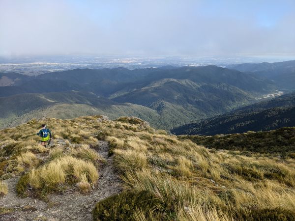
We’re through quickly and onto McGregor. The cloud starts to break up and patches of blue sky emerge. I can spot Dorset Ridge Hut on the other side of the valley, and then McGregor Biv below. We meet a big group of people on a guided trip, who also don’t seem to know exactly where they are. Running towards Angle Knob I finally start to feel more human, I am loving this. I have stopped thinking about bailing. I think it’s the sunshine. I’m sure I was a lizard in a former life! We sidle under the Knob and turn towards Jumbo. Run, run, run - this feels amazing! We change direction again and are onto the poled route of the Jumbo Holdsworth circuit. The waterproof pants and windproof jacket finally come off before the climb onto Mt Holdsworth. We comment on the confusing-ness of the sign times as we begin the steady descent to Powell Hut, eyeing the Waiohine valley spread out far below us.
It’s my first time visiting the new hut. I spot a group of people on the deck as I drop down the final section. The hut is very full and very loud - at such odds from being in our own little windblown bubbles for the past 14 hours. We take a few minutes to eat and sort gear for the valleys. We’re just over an hour ahead of schedule at this point, so it’s nice not to have too much time pressure.
My knees ache as we set off down the steep steps and the poles come out for a bit. We just cruise down the hill, feeling like we’re going much faster than we did on the Valleys SK (but ironically we’re not). Being a bit ahead on time means that we manage to make it through a quiet Totara Flats Hut, across a very busy Totara Flats, and almost to the junction at the bottom of Cone Saddle before the headlamps are permanently on. Groups of campers seem a little surprised to see us, but whoop and call out encouragement as we blast past their campfires.
I don’t mind Cone Saddle. It’s not that steep, you just need to be careful with following the track, which is definitely overgrown in some parts, and a bit open and ill defined from the rest of the surrounds in others. We briefly wander off, but quickly check ourselves and reroute. After that we have no trouble - apart from wondering repeatedly “are we nearly at the junction yet?”. I start feeling a bit dizzy and nauseous on the ups again. I try gels, smooshed balls, Roam, Rebuild, Tailwind, water - all to no avail. I just go somewhere else in my mind and push on.
A dog barks as we run past Cone Hut at 22:32, not stopping for water as we had topped up in Clem Creek. Feels like we’re on the home straight now. We learnt from our other little wanderings during SK Valleys and have no problem staying on the marked track this time. Possums run all over the place, up trees, across the track, even right in front of Katie’s feet! On and on we trot. We run the easy stuff and fast walk anything up or really rooty. We’re just cruising. Swing bridge, Marchant Stream, Smith Creek Shelter. Two hours, 50 minutes to get out - easy! We might even make it out under 23 hours. “My watch alarm is still set for 02:30,” says Katie, “let’s get out before that goes off”.
The Dobson Loop Track seems to drag on forever, until finally we reach the steps of the Puffer. I’m not dreading it this time either. The few hundred metres of vert seems to go quickly and we can spot the lights of the YMCA below us. Definitely on the home straight! I’m in front again and trot off down the hill. The clay is a little slippery, but we don’t have to slow down too much. Katie seems to be keeping up, so I keep running. Down, down, down. I always get mildly paranoid that I’ve missed the turn off down to Kiwi Ranch Road - even though I know I haven’t. We blast down the final steps, past the highwire course and the fence appears in front of us. We whoop loudly, Jean whoops back, running in, finishing strong in 22:36 and still a full 12 minutes before Katie’s alarm goes off.
For me it was definitely a day full of mental challenges - apart from the dizziness and struggling to get food down I was physically fine. We did a decent time in not the easiest of conditions and the pace felt pretty comfortable. Two down, one to go.