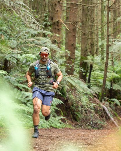
Ultra Trail New Caledonia

Simon Clendon
August 8, 2019 ShareThe UTNC at a glance:
5 Race options (distance/climb):
- 130km 6,200m
- 70km 3,200m
- 30km 1,800m
- 18km 600m
- 5km 300m
Location: New Caledonia, only a 3 hour flight
Language: French, but almost everyone has some English, especially in the tourist areas
Terrain: Single track, clay, rocks, lava fields, stream crossings, low bush, hills!
Climate: Warm, tropical climate. Temperatures are warm all year round and can get hot in the summer but seldom reaches above 35°C. Trade winds from the east southeast bring year long cooling breezes late afternoon and early evening.
Event Weather: Perfect, luckily - overcast mostly and a max of 25 degrees
What would I say to free race entry and three nights of accommodation courtesy of a Wild Things VIP Members' competition, Chateau Royal, and the UTNC organisers? I’ll take that! #itpaystobevip
I had the option of which distance to run. I decided not to do the 130km after having done the miler at Tarawera earlier in the year. I toyed with the idea of doing just the 5k and lazing around the rest of the time. Doing 70km seemed to do the entry win justice, though :-).
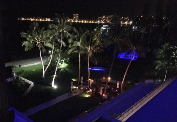
We booked Aircalin over on Friday afternoon (one of the event sponsors) and Air New Zealand back on Monday. We stayed at Hotel Chateau Royal, also a race sponsor, and donor of the accommodation part of the Wild Things prize. Nice apartment suite with breakfast thrown in and a wonderful restaurant for dinners. My wife, Nic, came along on the trip and said she was happy to enjoy the hotel and local area while I ran around the wilderness. Nic prefers to be out there supporting but the logistics were a bit complicated.
I missed the Thursday evening race briefing but it didn’t matter because a) the gear check was done race morning, and b) the briefing was all in French!
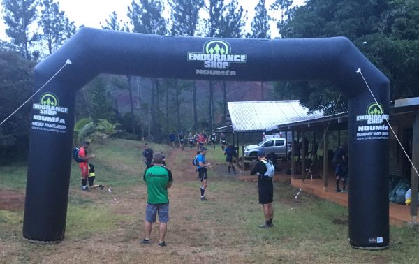
Up very early Saturday morning to catch a free bus from the hotel to the start. The bus stopped at the finish first for a gear check and then headed off into the dark to the start some way inland.
I thought we were going to start in the dark but by 6:30am it was already light. We jumped off the bus and walked a short distance to the start. The path to the start was clay and quite slippery so I started worrying about my shoe choice. The tread on my favourite trail shoes had pretty much all worn off and I was slipping all over the place. Yoiks! First mistake? Time would tell.
There was a short briefing before the start but it was all in French. I caught a few words from my school boy French and I think the jist of it was “It’s slippery AF so be careful!” I may have been mistaken but it made sense.
The forecast was for a maximum of 25 degrees and mainly cloudy. Perfect conditions and a relief as I was nervous about running in hot tropical conditions.
At 6:30am about 100 of us were set on our way without too much fanfare. I held back with the intent of just having a fun day out. No racing, just soaking it all in.
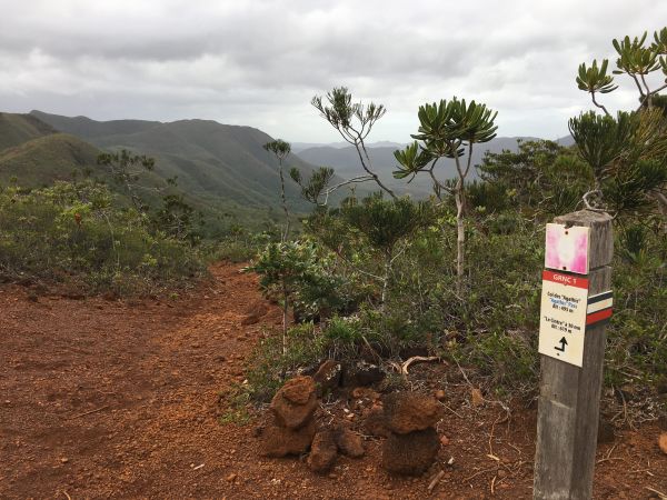
It was exciting to be running in such an exotic location. The first part of the route followed crystal clear rivers and streams on beautiful single track. I couldn’t help smiling! So different to what I am used to around Auckland. The vegetation is mainly scrubby with stunted trees. I was told that the high levels of nickel and cobalt(?) in the soil prevents the trees from getting very big.
At about 9km the first of about 7 or 8 major hills began. I just walked up as did everyone around me, although the field was beginning to spread out at that point.

I was rewarded with a magnificent view from the top of the hill. The “Grand Sud” Region (“Great South” or “Far South”) is a lot bigger than I expected. This interior part of New Caledonia is dominated by hills and red earth. I was reminded a little of parts of the Blue Mountains in Australia’s New South Wales, although the trees were different.
The rocky trail headed downhill to the valley floor far below. I ran a while with Patrick who came from somewhere west of Madagasca, at least that’s what I think he said. We managed to communicate using my poor French and his broken English. I tell you what, trail runners must be cut from the same cloth all over the world. Everyone I met was super friendly and happy to talk, even though they probably only understood a fraction of what I said.
Before long the first checkpoint was reached where I topped up my water and grabbed a couple of banana pieces before heading off again.
The volcanic nature of the area became obvious with a lot of scoria under foot and areas of old lava flows. The next section was a lot like running over Auckland’s Rangitoto Island - a good training ground if you are considering this event.
Up and over another hill and down into a valley with a decent sized river bisecting it. We were taken past a wonderful waterfall where I stopped for a photo or two.

Checkpoint two was at about 25km and I was feeling pretty good. A 300 metre climb to Col Anna and Pic du Pin was next so I made sure to have a good drink and a bite to eat.
After about 2km of climbing the trail flattened a little across a ridge line. At this point I had an almost 360 degree view and could see as far as the ocean. A great view but perhaps best enjoyed when stationary rather than when running along a very rocky ridge trail. I managed to catch my foot on a rock, cartwheel my arms to attempt to regain my balance, but ultimately failed. I had that slow motion feeling you get when you know you’re going to hit the ground and have way too much time to think about it. I could see some rocks coming and managed to turn slightly to avoid hitting square on. Boom! Shoulder, jaw, cheek bone and brow contacted the ground. That hurt! But what hurt more was the instant cramp in both of my calf muscles. I couldn’t reach my feet to relieve the spasms because I was half upside down in some scrub off the side of the track. Boy did I howl! It felt like the muscles were tearing and I couldn’t stop them. Now, what is the French word for “Help!”?
As I lay there whimpering I noticed my sunglasses in pieces beside me and drips of blood on the lenses. Cool! I attempted to reassemble my sunnies to distract myself from the cramp pain.
I finally managed to reach my feet to relieve the cramping. The yoga my coach got me to do was paying off - ha ha! Fortunately the next runners arrived and helped me to my feet. It was Colin and Tarn from Australia who I had met on the bus. Colin asked if I wanted to head back to the nearby checkpoint or go on. I seriously thought about heading back as I still had about 50km to go but said I’d walk it out a bit and see how it felt.
The Aussies headed off and I limped along wiping some blood out of my eye and feeling quite sorry for myself. After a bit I tried a wee jog that, although slow, meant I reckoned I would be able to forge on and finish.
I continued up the hill and was able to jog down the other side to the next checkpoint at 39km. More food and drink helped me feel a little better and I headed off to tackle the rest of the course.
 On the next section i saw some pitcher plants which was really cool. I was excited to see these carnivorous plants in the wild - a real treat!
Up, up and over another high point and down again. My abused calf muscles did not like the downhill sections at all. The ground was dry but reasonably steep with loose dirt on top. My shoes had no real grip so I had to grab trees and shrubs to control my descent. Decent studs would have helped. Some of the locals put socks over their shoes and slid down. Odd but effective!
The afternoon shadows were growing long and I still had two major hills to get over. The next checkpoint was at the top of the next hill underneath some wind turbines. The turbines sounded mournful as they whipped around. I still had to travel uphill for about 5km to the top so just put my head down and trudged up.
I got closer and closer to the turbines but was puzzled that I hadn’t seen a trail marker for a while. The marking was very good with orange tape every 50-100m and each intersection well indicated with yellow spray paint. I must have had my head down too much at a critical point because I had missed a turn. Completely my fault. I looked across the valley and could see people in the far distance making their way up a steep track that started far below me. Argh (and a French swear word or two)! I looked up and thought I could go cross country to the ridgeline above me and cut across to rejoin the route rather than retrace my steps and lose all that elevation. Nope, didn't work. Bad idea. I ended up dropping back down through thick and prickly scrub to join the original track with the bonus of more scratches and blood.
I finally reached checkpoint 4 on the high ridge but by now it was starting to get dark and cold. I put on my warm gear before eating some food and refilling my water bottles. The checkpoint was in a concrete hut containing service gear for the turbines but was sheltered and warm. A lovely volunteer, who also happened to be a nurse, cleaned up my wounds and slapped on some bandages. Right, ready to tackle that final 15km and last two hills!

It was fully dark now so I decided to walk the tricky bits so I didn’t fall again. I warmed up as I dropped down towards the next valley floor. I started sweating again but was too lazy to take off my thermal top. I probably should have but I thought it would cool down more (it didn’t).

I had another moment of confusion before getting to the final checkpoint. The translated course notes said I would go through a mine before the aid station. I kept looking for a mine shaft or tunnel but saw nothing. My GPS distance suggested I should be past it already. There was only a large gate and road beyond with a couple of lights on it. I stopped and waited and soon another runner came along and seemed confident about where to go. A short run up the lighted road and I reached the aid station. I worked out later that “go through a mine” meant “go through a mine property”. The mines here are all open cast anyway.
I was given a yummy hot soup and polished that off before heading out again. Another runner by the name of Fabien had just zoomed ahead so I wanted a bit of company for the next, and final, long hill section.
Fabien was actually running up the hill so I just let him go. Bugger that! However, he soon started walking painfully so I caught and passed him. Fortunately I still had my climbing legs. As I passed Fabien, I thought I‘d express my feelings about the endless hill - “F**k this sh*t!”. I feel the shared suffering cheered him up a little!
I told myself all I had to do was go into zombie mode and keep climbing until the ground beneath my feet started heading down. Finally that moment came and I saw a glimmer of lights far below. Civilization! I just had to endure 3km of steep downhill, a “wee bump” (according to the notes), and a kilometre of relative flat trail before the glorious sight of the finish line came into view.
 That took a bit longer than planned due to the fall (15h08m13s - the clock time is for the 130km event) but was epic nevertheless. At the finish there was a large bunk room where I had a wee lie down to recover.
After feeling somewhat recovered I had a cup of tea made for me by one of the wonderful volunteers. Fabien happened to wander past and identified me as “Ah! F**k this sh*t!”. That made me laugh. Fabien’s mum had come to take him home and she kindly took me as well after some Franglaise and hand signs. Well, we started driving in what I hoped was the direction of my hotel 20km away in Anse Vata. On the way I managed to exchange a few sentences of conversation and was quite pleased with myself. At the hotel Fabien’s mum gave me a kiss on both cheeks and I headed to my room for a very overdue shower and a lovely comfortable bed.
I highly recommend this event. Friendly people, very well organised, and terrain that is breathtaking (the hill climbs will take your breath, too ha ha!). Combine this with a week’s holiday on a tropical island and you have a winner.