Last Updated: 29th Mar 2024
The Bloody Limit
Submitted by Tony Sharpe
Last Updated: 29th Mar 2024
Open
Grunt Factor: 46 ?
Gnarl Factor: 85 ?
11.5km
1400m
1400m
1921m
Last Updated: 29th Mar 2024
Submitted by Tony Sharpe
Last Updated: 29th Mar 2024
Open
Grunt Factor: 46 ?
Gnarl Factor: 85 ?
11.5km
1400m
1400m
1921m
Back country - remote
Loop
Mountainous
Native bush
Riverside
Open tussock/grasslands
Open ridges/tops
Easy Single Track
Moderate Single Track
Technical Single Track
Untracked / Route only
Average Uphill Gradient: +26.1%
Average Downhill Gradient: -18.7%
Login as a VIP to see the trailhead information.
6:00
Slow
4:30
Moderate
3:00
Fast
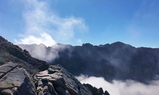
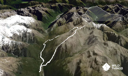
Its a push to call the ascent of Cassidy and Blimit a run, but the downhill will certainly allow plenty of that. This is a really technical and exposed route along the top, you'll want to consider your experience levels and maybe try out other circuits in the area first, like Avalanche Peak for example. This one is significantly harder than Avo Peak. Blimit gets is name as an abbreviation - early climbers/ explorers referred to its summit push as "The Bloody Limit". You have been warned!
Start up Con's Track from the bridge over the Bealey River at the start of the Punchbowl falls walk. You'll quickly be into your uphill gears following a well marked trail to the bushline. From here be careful to take the right route, going the wrong way will see you bluffed.
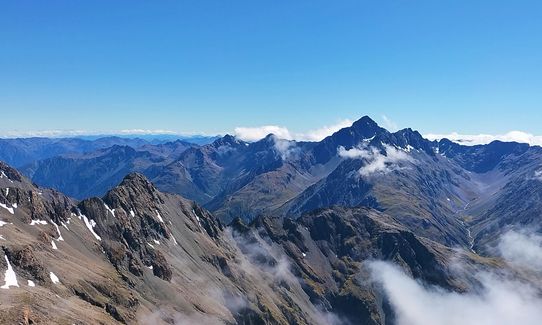
From the bushline follow goat trails and maybe a cairn or two under the bluffs slowly climbing above screes and tussock slopes. A gully is met after about 300m, this ascends steeply on loose rocks to pass between the bluffs to join the wide Mt Cassidy ridge above the cliff-lines. Be careful with loose boulders, and the massive drop into Punchbowl Creek. Then follow the ridge for a kilometre until a slope climbing a side spur confronts you. If it is snow covered take care to put your fall-line away from the Punchbowl Valley (550m drop). Joining the spur leads directly to Mt Cassidy summit. First peak bagged!
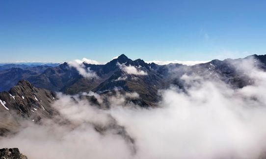
From the summit of Cassidy the ridge narrows and steepens as it descends to a saddle, then climbs over a buttress towards Mt Blimit. The second saddle at the foot of Mt Blimit will also be your descent route to Bill's Basin - look for the tarns .
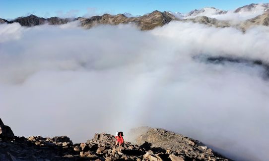
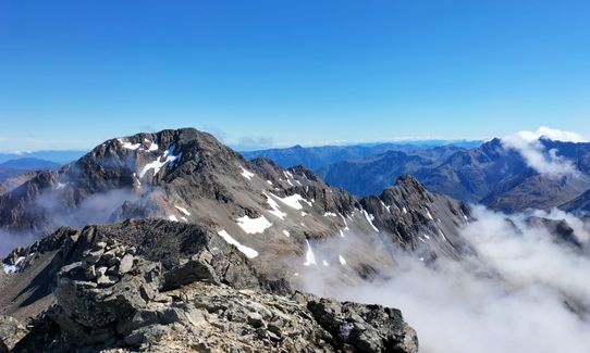
Climbing Mt Blimit is not compulsory, however is very worthwhile for the views. Ascend the true-right side of the ridge, avoiding where possible the huge exposure into Punchbowl Creek. This ridge is loose, maybe corniced in winter / spring, and should not be followed beyond the summit of Mt Blimit. A traverse of the northern ridge to Temple Col is for experienced climbers only - not walkers or runners!
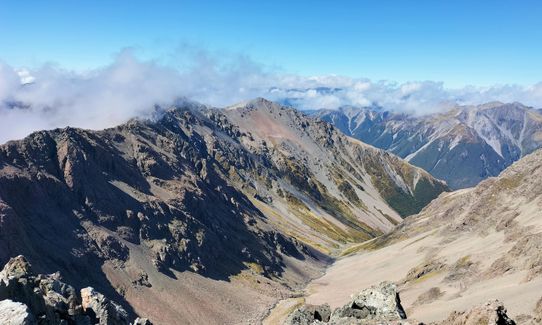
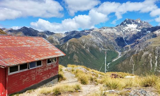
Descend the ridge back to the first saddle south. From here a scree slope descends directly to the large tarn in Bill's Basin. Skirt around the tarn heading northwest towards the western spur of Mt Blimit. Do not descend directly to Temple Basin Ski-field. Once the wide back of the spur is joined, follow it downwards until Page Shelter becomes visible on its northern escarpment. Several scree gullies descend towards the shelter, follow these, choosing to slowly traverse west as well towards the track that leads to Page Shelter from the main ski-field. Once the track is gained it is an easy descent to the ski-field, and then the Temple Basin track back to highway 73.
Finish off following the wide and well developed Arthurs Pass Trail back to the village - your adrenaline should really be pumping as you speed back to 'town' and a well earned beverage at the Wobbly Kea - your knees are likely to still be wobbling as you contemplate country you have just traversed!
This trail includes the peak Blimit.
Bag 2 of Arthurs Pass's more challenging peaks
Descend Temple Basin Skifield
Devils Punchbowl waterfall nearby
Plenty of parking around Arthurs Pass Village
0 km
1 minutes
Unknown
No
Extreme.
Have a map and a really good route guide. This one is for experienced mountain goats in good weather only.
Patchy.
Waterproof leggings, Thermal leggings, Lightweight fleece top, Long-sleeved thermal top, Seam-sealed waterproof jacket, Windproof jacket, Gloves, Beanie/thermal headwear, Personal Locator Beacon (PLB), Whistle, First aid kit, Extra food for emergencies, Survival bag, Cellphone, Compass, Map, Crampons / microspikes (for winter conditions), Gaiters
Bring your own until Temple Basin
Not recommended in snow/ winter/ spring. Avalanche prone, and for mountaineers only at that time. Even in summer be prepared to take ice axe and crampons if there is snow around the tops
Many hazards here - height, loose rocks, snow, ice, vertigo. As per the above, for the more experienced mountain goats really
The Wobbly Kea
Arthurs Pass Village
Monteiths beer!
Trail Legend
Fastest Known Times (FKTs)
You and The Bloody Limit
As a VIP member you can record private notes for this trail, see all of your times and more.
Already have an account? Login now
I did this loop today and loved it! I didn't really read the descent instructions and we attempted to drop straight to the skifield from the tarn and got bluffed out. We did manage to find our way down a gully but it was slow going and a bit sketchy. The ridge was epic, and well worth climbing Blimit for the views into Goat Pass and across to Mt Oates and Lake Mavis
April 6
DT
It's a sustained slog up to the Cassidy ridgeline, I recommend walking poles for this and the looser sections. Travel on the ridge is good on block/boulder, but slows right down through technical and exposed sections on the ridge. You need a good head for heights and good balance.
The descent is steep and reasonably technical in places but overall you can keep a good pace, once on the Temple Basin access track it's a fairly easy run down on a loose rocky track.
It's my first time trying to run anything like this and I managed it in under 4 hours.
January 26, 2022
These overlap with this trail to some degree. You may wish to combine them but please note that to qualify for FKTs on these runs you should record a separate activity for each.
The Wild Things Trail Directory is proudly supported by 
Send to your phone
Scan the below QR code to open this trail on your phone.

Tip: position the QR code in your phone camera screen.


