Last Updated: 21st Sep 2023
Oates for Breakfast
Submitted by Mike Steel
Last Updated: 21st Sep 2023
Open
Grunt Factor: 65 ?
Gnarl Factor: 71 ?
29.0km
1500m
1500m
2041m
Last Updated: 21st Sep 2023
Submitted by Mike Steel
Last Updated: 21st Sep 2023
Open
Grunt Factor: 65 ?
Gnarl Factor: 71 ?
29.0km
1500m
1500m
2041m
Back country - remote
Loop
Mountainous
Native bush
Riverside
Lakeside
Open tussock/grasslands
Open ridges/tops
Moderate Single Track
Technical Single Track
Untracked / Route only
Average Uphill Gradient: +12.4%
Average Downhill Gradient: -11.1%
Login as a VIP to see the trailhead information.
9:00
Slow
7:00
Moderate
5:30
Fast
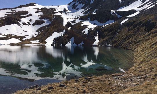
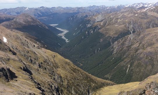
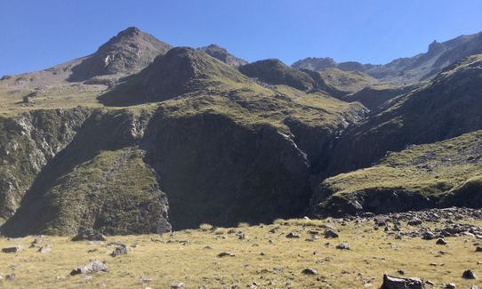
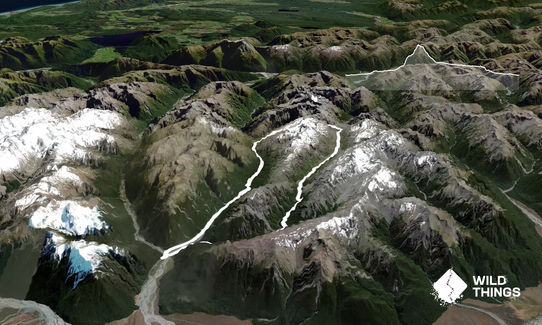
Another fine summer-time alpine circuit at Arthur's Pass, up the Mingha River to Lake Mavis, and back down the Edwards valley from Taruahuna Pass to the start. To add to the adventure you'll climb up Mt Oates (2041 m) via its west ridge, a prominent feature seen clearly from the highway a little north of Klondyke Corner. Mt Oates was named after Captain Lawrence Oates who perished on Scott's ill-fated Terra Nova Antarctic expedition, and is best remembered for his final words: "I am just going outside and may be some time".
Starting from near Greyney's shelter, follow the markers (which now lead under the railway line) and follow them down to cross the Bealey River then start up the Mingha valley (mostly on the western side). Note you are doing the last half of the Coast to Coast run here, but in the `wrong direction'. Pick up the track over Dudley Knob (tree roots and occasional slips makes this section a little slow) and head past Mingha Biv and the spectacular Kennedy Falls, after which things open up a bit and you start climbing to Goat Pass (much of it on boardwalk).
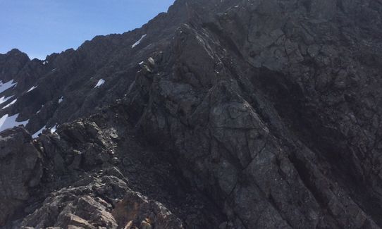
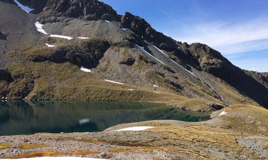
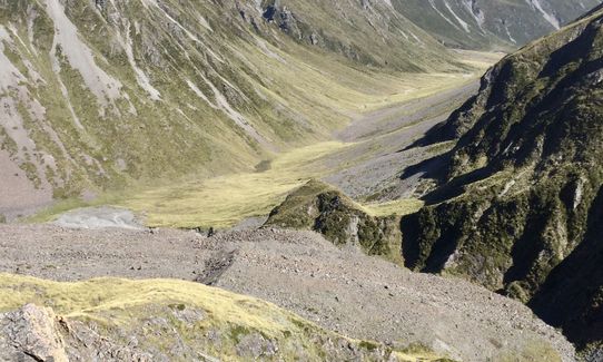
Somewhere near the high point on the pass (before you start to drop down to the hut) leave the track and climb directly uphill keeping left on a broad ridge that takes you to the beautiful alpine Lake Mavis. Step across outflow of the lake and head east up grassy slopes and start climbing scree/rock towards a deep (partly hidden behind a large buttress) gully that leads to a col on the west ridge of Mt Oates. At the top of this col join the airy west ridge which provides pleasant rock scrambling (alpine grade 1+) directly to the official summit, with great views en route. The southern summit of Mt Oates is slightly higher but it requires care and time to negotiate the steep traverse down and back up again to it (and return). Instead head north along the main ridge, and descend towards a tarn and slopes leading towards Taruahuna Pass (don't drop straight down from Mt Oates into the Edwards as it is bluffed below). From below Taruahuna Pass you rejoin a track that leads through very scenic open country down-valley to the Edwards hut.
The track then continues on the left of the river before climbing the bush above the river to avoid a waterfall. Once you've dropped back down and passed the Edwards River east branch it's open and easy running in the riverbed and bush section back out to the road.
This trail includes the peak Mount Oates.
Alpine lake, high waterfall, two picturesque valleys, spectacular mountain views.
5 km
5 minutes
Unknown
No
Moderate.
From Lake Mavis don't try and gain the west ridge nearby (low down) - the first bit of the ridge leads to a big drop! Instead (as mentioned in the Detailed Description) head around the lake and up into a gully that leads up to a col. Also from the summit of Oates don't try and drop straight down to the Edwards valley.
Non-existent.
Thermal leggings, Long-sleeved thermal top, Seam-sealed waterproof jacket, Gloves, Beanie/thermal headwear, Personal Locator Beacon (PLB), Whistle, First aid kit, Extra food for emergencies, Survival blanket, Cellphone, Compass, Map
Plenty of water for most of the way (in rivers/streams)
Only possible in summer when the ridges are clear of snow.
Also, not possible after heavy rain as the rivers will be too high.
Good visibility and settled weather is also advised.
Sheffield Pie Shop
Sheffield
http://www.sheffieldpieshop.co.nz/
best pies ever
Fastest Known Times (FKTs)
You and Oates for Breakfast
As a VIP member you can record private notes for this trail, see all of your times and more.
Already have an account? Login now
DR
Excellent adventure. We hiked this trail rather than ran, although we ran a little out of the Edward's valley to beat darkness. Took us 13 hours. We did take our boots off for the ~6 river crossings on the way up, and the ~5 on the way down. We also down climbed and up climbed to the higher Mt Oates peak which we enjoyed. We followed the advise in Nick's review and kept true left (orientation when looking downstream) on the way down, crossing the creek just below the tarn and skirting the ravines. note -someone has built cairns to mark the route to the Taruahuna pass, not always easy to spot but there. Another route note would be that when we exited Oates North along the ridge there are a number of buttresses to climb over. We were happy enough until we got to the last upclimb before the 1978m peak. We cut down the scree on the right side at this point and sidled around and up and over the ridge on the otherside of the peak because we did not want to do the upclimb at the 1978m peak. Looking at the topo now I wonder if cutting down the left side would have been shorter - if someone does that please comment.
February 29
These overlap with this trail to some degree. You may wish to combine them but please note that to qualify for FKTs on these runs you should record a separate activity for each.
The Wild Things Trail Directory is proudly supported by 
Send to your phone
Scan the below QR code to open this trail on your phone.

Tip: position the QR code in your phone camera screen.


