Last Updated: 8th Jan 2024
Hawdon-Edwards Classic
Submitted by Mike Steel
Last Updated: 8th Jan 2024
Open
Grunt Factor: 60 ?
Gnarl Factor: 75 ?
30.0km
1100m
1000m
1386m

Last Updated: 8th Jan 2024
Submitted by Mike Steel
Last Updated: 8th Jan 2024
Open
Grunt Factor: 60 ?
Gnarl Factor: 75 ?
30.0km
1100m
1000m
1386m
Back country - remote
Point to Point (one way)
Undulating, some big hills
Native bush
Riverside
Open tussock/grasslands
Open ridges/tops
Moderate Single Track
Technical Single Track
Untracked / Route only
Average Uphill Gradient: +9.3%
Average Downhill Gradient: -8.0%
Login as a VIP to see the trailhead information.
8:00
Slow
5:30
Moderate
4:30
Fast
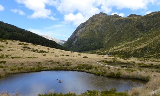
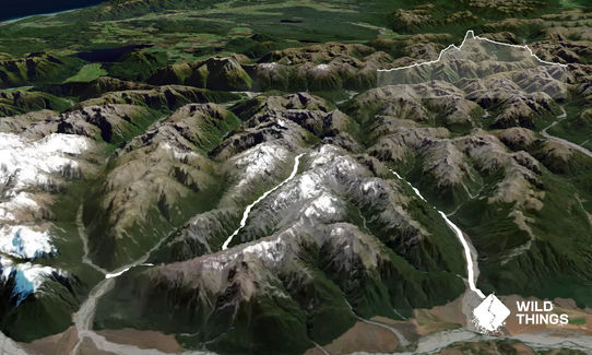
A popular 2-3 day tramping route that crosses the main divide (twice) albeit briefly, and is a rewarding run in fine weather, with plenty to see along the way: rivers, low alpine passes, tarns, mountains, bush and two huts. There's a 22km bike ride back to the car.
Have run this several times (in both directions), and it's debatable which way around is best. But the bike ride is best from the Edwards end, especially if it's north-westerly, so it's described that way here.
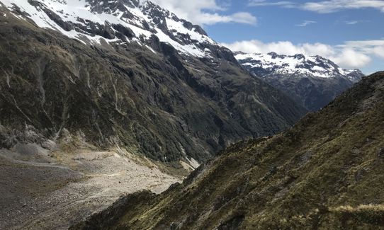
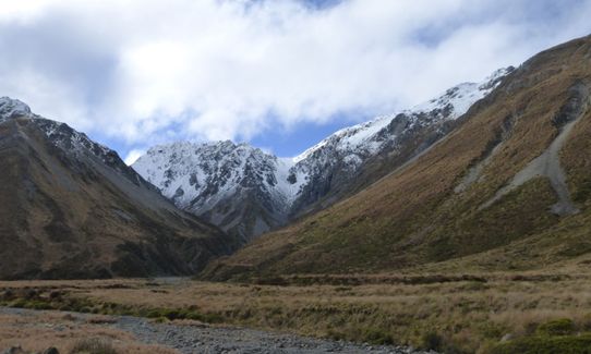
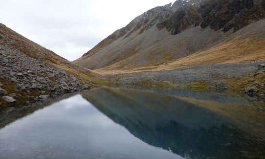
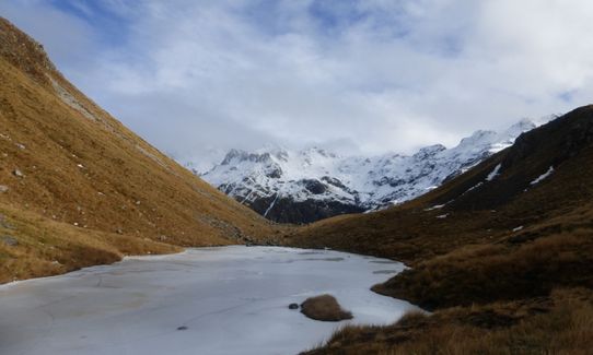
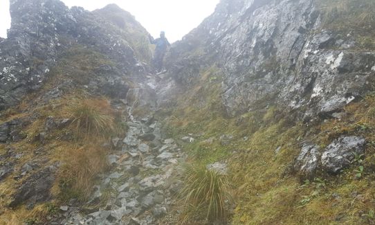
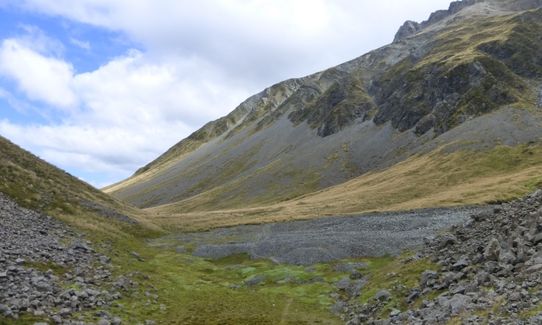
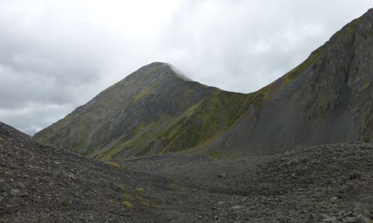
Drop a bike at/near Greyney's shelter, and drive to the Hawdon valley car park. A trail leads north from the car park through a short section of bush and down to cross the Hawdon. Follow the marked trail (which crosses the river twice more higher up) leading with little fuss to the new Hawdon hut. The trail then climbs steeply up through bush then scrub to a scenic viewpoint well above the Twin Fall Stream, and then drops down to it in a scrubby hanging valley and leads up to the tarn at Walker Pass (this section is fairly slow going, keep a eye out for markers). Once you leave Walker Pass you're on the West Coast following the upper Otehake River, but only for a short distance (1km at most) where you turn left up the long gently sloping side valley that leads up to Tarn Col. The views from the tarn near Tarn Col are superb, especially of Mt Franklin. To descend Tarn Col there's a steep scree descent just to the south of the Col; in the reverse direction climb steep scrub by the waterfall. This brings you down to Taruahuna Pass, a large expanse of broken rock that fell off nearby Falling Mountain, and which requires some care till you pick up the faint and runnable cairned trail. From here, begin the long and pleasant trip down the scenic Edwards Valley to the Edwards Hut. The track then continues on the left of the river before making a grunty traverse in the bush above the river. Once you've dropped back down and passed the Edwards River east branch it's all plain sailing and cruisy running out to the road.
tarns, mountains, different vegetation across the divide
Safe parking, and camping, well off the main highway.
25 km
26 minutes
Unknown
No
Moderate.
Take a map and compass. Be particularly careful to not miss the turn left up the side valley to Tarn Col (occasional trampers have done so and ended up in the Otehake wilderness area!).
Non-existent.
Long-sleeved thermal top, Windproof jacket, Beanie/thermal headwear, Personal Locator Beacon (PLB), Whistle, First aid kit, Extra food for emergencies, Survival blanket, Cellphone, Compass, Map
Plenty of water in side streams the whole way.
Feasible in summer-autumn, and only when the rivers are not high. In winter/spring the passes can be snowed under and this can hang around into late spring. There are unavoidable numerous river crossings (in the unlikely event the final Mingha/Bealey river is uncrossable there is a rail bridge a short distance south).
Apart from the navigation issue above, take care on the steep descent from Tarn Col to Tarahuna Pass and in crossing the broken rock of the pass (i.e. probably best not to run this bit until you reach the faint trails, to avoid any risk of twisting your ankle in this remote spot).
Trail Legend
Fastest Known Times (FKTs)
You and Hawdon-Edwards Classic
As a VIP member you can record private notes for this trail, see all of your times and more.
Already have an account? Login now
Great day out! Gorgeous country and some unique landscapes through Tarn Col and Taruahuna Pass. I was delighted to see kākāriki in the Hawdon and hear lots of kea in the Edwards.
No problems with snow or river levels today.
A few words of advice - bring an older pair of shoes, be prepared for wet feet, and if you're biking note that the last 4 k's are gravel!
October 21
Run on a clear day, mild NW wind.
Would be a problem with swollen streams/rivers, particularly the stream draining Tarn Col to the West (joining the East Branch of the Otehake), which even with minor raise in level would make slow going. Low as it was when we did it on 19 April 2022, it was boulder-hopping fun and good travel.
Great day out
Sean
April 22, 2022
A really stunning run. I prefer starting from the Edwards, as this gets the hard stuff out of the way, and then you finish with a fast, easy cruise down the Hawdon. I also prefer going up to Tarn Col (vary steep) rather than down.
Mike Steel’s times I find are always optimistic, so I suggest you add an hour onto each of the categories; ie 5.30 fast, 6.30-7hr intermediate, 9hr slow.
March 19, 2021
Tarn col- always pays to get the approach right, I have been left hanging once or twice here, literally hanging by the tussock. Great country
December 31, 2018
These overlap with this trail to some degree. You may wish to combine them but please note that to qualify for FKTs on these runs you should record a separate activity for each.
The Wild Things Trail Directory is proudly supported by 
Send to your phone
Scan the below QR code to open this trail on your phone.

Tip: position the QR code in your phone camera screen.


