Last Updated: 15th Apr 2024
Routeburn: Divide to Conical Hill
Last Updated: 15th Apr 2024
Grunt Factor: 72 ?
Gnarl Factor: 43 ?
40.0km
1940m
1940m
1515m
.jpg?tr=w-542,h-325)
Last Updated: 15th Apr 2024
Last Updated: 15th Apr 2024
Grunt Factor: 72 ?
Gnarl Factor: 43 ?
40.0km
1940m
1940m
1515m
Back country - remote
Out and Back
Mountainous
Native bush
Lakeside
Open tussock/grasslands
Open ridges/tops
Easy Single Track
Moderate Single Track
Technical Single Track
Average Uphill Gradient: +9.3%
Average Downhill Gradient: -9.3%
Login as a VIP to see the trailhead information.
9:00
Slow
7:00
Moderate
5:00
Fast
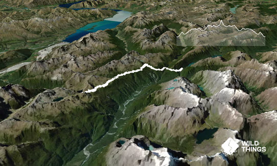
The yin to Conical Hill and Return's yang - a great way to see the other half of the Routeburn Track, without the logistical faff of running it point-to-point.
From the Divide Carpark, there's only 500m of relatively flat to warm up before kicking into the first climb of the day. At 2.5km you'll reach a junction with the option to take a short side trip up to Key Summit (918m) with a nature loop and views of Lake Marian, but otherwise stay left and crack on. You could also save Key Summit for the return leg, assuming there is anything left in yours.
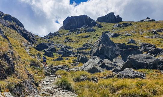
Being a Great Walk, the Routeburn track is obvious and easy to follow, but still packs a reasonable amount of technical rocky and rooty trail, mixed in with stretches of nice, easy running. Any junctions are clearly marked with the classic DOC signboards, and orange triangles or poles are dotted along the way.
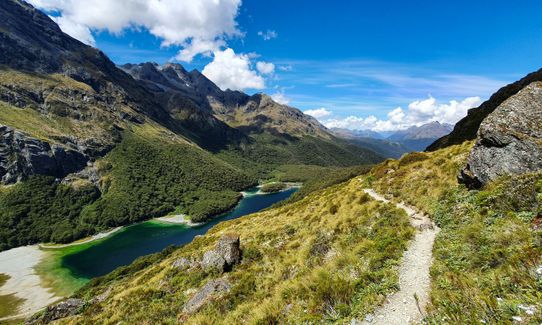
Much of the early route is bush-clad as you pass Lake Howden, Earland Falls and the 'Orchard,' before descending to Lake MacKenzie (and the hut, should you need facilities).
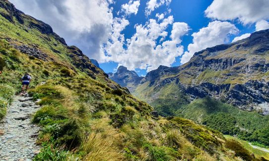
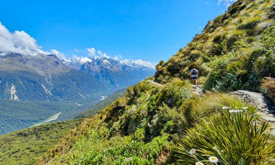
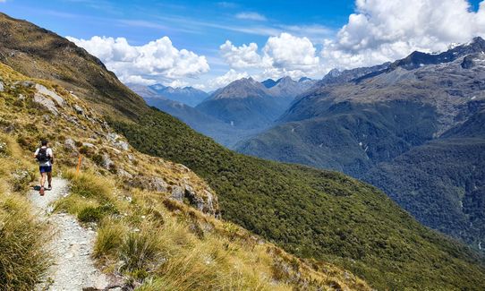
From Lake MacKenzie the track climbs steadily to clear the bushline, with stunning views back over the lake and the range behind it. It then turns to the north to sidle along the Hollyford Face with dramatic views across the Hollyford Valley and Darran Mountains, before a small climb up to Harris Saddle.
Once at the saddle, the track to Conical Hill is tucked behind the shelter - a steep 1km push that features some stairs and some scrappy technical track.
This is the high point of the route, and a perfect chance to refuel while you soak in the 360-degree views!
Once you've had enough, retrace your steps down Conical Hill and back on to the main Routeburn track. Now it's back to the Divide as fast or as slow as you like - there are still plenty of great views to enjoy, or you can open up a little on the net downhill (noting that there are a still a few small climbs to keep you honest).
If you've been fortunate to enjoy good weather, a quick dunk under the Earland Falls on your way past will do wonders to revive the legs for the last 6.5 km back to the car
This trail includes the peak Conical Hill.
Earland Falls (174m), Lakes Howden, MacKenzie and Harris, beautiful views of the Hollyford Valley and surrounding mountains
Large designated carparking area, with shelter and info panels, toilets, and cell tower (eg if sending start/finish intentions). Various transport operators provide transfers to the Divide - check online for current timetable and cost info.
0 km
0 minutes
No
No
Easy.
The track is well-formed and easy to follow. Any junctions are well sign-posted.
Non-existent.
Waterproof leggings, Thermal leggings, Lightweight fleece top, Long-sleeved thermal top, Seam-sealed waterproof jacket, Gloves, Beanie/thermal headwear, Personal Locator Beacon (PLB), Whistle, First aid kit, Extra food for emergencies, Survival bag, Cellphone, Map, Headtorch and spare batteries, Crampons / microspikes (for winter conditions)
Several small, clear streams cross the track just before reaching MacKenzie Hut, and along the several km of sidle along the Hollyford Face. MacKenzie Hut itself is also an option. Filter or treat if you're concerned.
Ice and snow in winter. Avalanche paths are known to cross the Routeburn and Conical Hill tracks - check the DOC website or call their Te Anau Visitor's Centre for up-to-date track conditions.
The section from MacKenzie Hut to Conical Hill can be very exposed to the weather. The track can be very popular with hikers over summer, so just be aware and considerate of others track users.
Trail Legend
Fastest Known Times (FKTs)
You and Routeburn: Divide to Conical Hill
As a VIP member you can record private notes for this trail, see all of your times and more.
Already have an account? Login now
These overlap with this trail to some degree. You may wish to combine them but please note that to qualify for FKTs on these runs you should record a separate activity for each.

Length: 28.0km
Level: Intermediate - Experienced
The Wild Things Trail Directory is proudly supported by 
Send to your phone
Scan the below QR code to open this trail on your phone.

Tip: position the QR code in your phone camera screen.


